Hewitt Peak
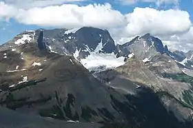
Hewitt Peak is a 3,066-metre (10,060-foot) mountain summit located on the western border of Kootenay National Park, in the Canadian Rockies of British Columbia, Canada. The peak is also known locally as Mammoth Peak, and originally as Mount 10060.[3] The alternate names derive from its outline profile resembling a mammoth, and its elevation as measured in feet.[3] No name for this mountain has been officially adopted yet. Its nearest higher peak is Tumbling Peak, 2.5 km (1.6 mi) to the north-northwest,[1] and both are part of the Vermilion Range. Park visitors can catch a glimpse of the peak from Highway 93, also known as the Banff–Windermere Highway.
| Hewitt Peak | |
|---|---|
 Hewitt Peak seen from Highway 93 | |
| Highest point | |
| Elevation | 3,066 m (10,059 ft) [1][2][3] |
| Prominence | 548 m (1,798 ft) [2] |
| Parent peak | Tumbling Peak (3121 m)[1] |
| Coordinates | 51°05′32″N 116°12′42″W [2] |
| Geography | |
 Hewitt Peak Location of Hewitt Peak in British Columbia  Hewitt Peak Hewitt Peak (Canada) | |
| Location | Kootenay National Park British Columbia, Canada |
| Parent range | Vermilion Range[4] Canadian Rockies |
| Topo map | NTS 82N01[5] |
| Geology | |
| Age of rock | Cambrian[6] |
| Type of rock | Limestone |
| Climbing | |
| First ascent | 1906, Dominion Land Survey[3] |
| Easiest route | Scrambling |
History
The first ascent of the mountain was made in 1906 by members of the Dominion Land Survey.[3] It was first named Mount 10060 by Kate Gardiner and party in 1933, when they climbed nearby Foster Peak and Mount 10240 (now known as Tumbling Peak).[3] Hewitt Peak may be named for Hewitt Bostock, Martin Hewitt or James J. Hewitt.
Geology
Hewitt Peak is composed of limestone, a sedimentary rock laid down during the Precambrian to Jurassic periods.[7] Formed in shallow seas, this sedimentary rock was pushed east and over the top of younger rock during the Laramide orogeny.[8]
Climate
Based on the Köppen climate classification, Hewitt Peak is located in a subarctic climate zone with cold, snowy winters, and mild summers.[9] Temperatures can drop below −20 °C with wind chill factors below −30 °C. Precipitation runoff from the mountain drains east into Numa Creek, a tributary of the Vermilion River, or west into tributaries of the Kootenay River.
References
- "Hewitt Peak". OpenTopoMap.org. Retrieved 2019-08-21.
- "Hewitt Peak". PeakVisor. Retrieved 2019-08-21.
- "Mount 10060". PeakFinder.com. Retrieved 2019-08-21.
- "Vermilion Range". Peakbagger.com. Retrieved 2019-08-21.
- "Vermilion Range". Geographical Names Data Base. Natural Resources Canada. Retrieved 2018-12-18.
-
Baird, David M. (1964). "Kootenay National Park: Wild mountains and great valleys"" (PDF). Ottawa: Geological Survey of Canada. Retrieved 2019-08-21. Cite journal requires
|journal=(help) -
Belyea, Helen (1960). "The Story of the Mountains in Banff National Park" (PDF). Geological Survey of Canada. Archived (PDF) from the original on 2 October 2015. Retrieved 2019-06-23. Cite journal requires
|journal=(help) - Gadd, Ben (2008). "Geology of the Rocky Mountains and Columbias". Cite journal requires
|journal=(help) - Peel, M. C.; Finlayson, B. L.; McMahon, T. A. (2007). "Updated world map of the Köppen−Geiger climate classification". Hydrol. Earth Syst. Sci. 11: 1633–1644. ISSN 1027-5606.
External links
- Parks Canada web site: Kootenay National Park
- Climbing Hewitt Peak: by Matt Ruta
- Winter photo of Hewitt Peak: mountainsoftravelphotos.com
- Flickr photo: Hewitt Peak