Cherupuzha (Kannur)
Cherupuzha is a town in Kannur district, Kerala, India. It is the headquarters of the Cherupuzha Panchayat which is a special grade panchayat in Kerala. [4]
Cherupuzha | |
|---|---|
Town | |
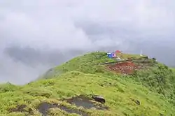 Kottathalachi Mount | |
 Cherupuzha Location in Kerala, India  Cherupuzha Cherupuzha (India) | |
| Coordinates: 12.2728°N 75.3672°E | |
| Country | |
| State | Kerala |
| District | Kannur |
| Taluk | Payyanur |
| Government | |
| • Body | Grama Panchayat |
| Area | |
| • Total | 75.64 km2 (29.20 sq mi) |
| Elevation | 72 m (236 ft) |
| Population (2011)[3] | |
| • Total | 30,733 |
| • Density | 410/km2 (1,100/sq mi) |
| Languages | |
| • Official | Malayalam, English |
| Time zone | UTC+5:30 (IST) |
| PIN | 670511 |
| Telephone code | 04985 |
| ISO 3166 code | IN-KL |
| Vehicle registration | KL 59 |
| Niyamasabha constituency | Payyanur |
| Lok Sabha constituency | Kasaragod |
| Nearest Railway station | Payyanur |
| Website | www |
Location
It is located about 31 km east of taluk HQ Payyanur, 66 km north east of district HQ Kannur, 524 km from Capital city Thiruvananthapuram, 332 km away from Eranakulam, 150 km from Kozhikode, 121 km away from Mangalore and 326 km from Bangalore.
History
Cherupuzha and its surrounding areas was ruled by many royal dynasties in the past, including the Mooshika dynasty of Ezhimala, Chirakkal dynasty of Kolathunadu, Tipu Sultan of the Kingdom of Mysore, before it became a part of the British Raj. The original inhabitants of the area were primarily Hindus. Later on this region gained a sizable Christian and Muslim population. Now the place has Christians as majority. The arrival of Christians from middle Kerala helped in the development of this place, this led to the construction of schools, colleges, hospitals etc. in the area. The economy was agrarian with strong feudal system - Janmi-Kudiyan system - permeating everyday life in past and in the present mainly small and medium farmers.
Geography
Cherupuzha is a hilly town (part of Western Ghats) on the eastern side of Kannur district. The terrain is undulating in nature and the extreme eastern side has forests bordering Karnataka state.
Connectivity
Satellite towns that are nearby and places at a longer distance which has direct bus route from Cherupuzha includes Pulingome, Palavayal, Kozhichal, Thirumeni, Padiyotchal, Peringome, Chittarikkal, Vellarikundu, Panathur, Alakkode, Chemperi, Payyavoor, Iritty, Payyanur, Kanhangad, Taliparamba, Kannur, Kasaragod, Kozhikode, Mangalore, Bangalore, Ernakulam, Thrissur, Thodupuzha, Pala, Kottayam, Pathanamthitta etc. These population centres are well connected to Cherupuzha by road.
Water bodies
Tejaswini River, also called "kariankode puzha" in Malayalam, which is comparatively small among 44 rivers of Kerala, flows beside this town. It originates from Brahmagiri hills of Coorg forest in Karnataka, enters Kerala near Pulingome, flows through the districts of Kannur and Kasaragod and meets the Arabian Ocean, near Nileshwaram as a part of Valiyaparamba Backwaters. Tejaswini, which is 64 km long, do have a rafting stretch of 20 km with plenty of rapids extending up to class-3.
Places of worship
- Kottathalachi Mount
- Cherupuzha Shri Ayyappa Temple
- St. Mary's Forane Church
- Pulingome Makhaam
- St. Joseph's Church Pulingome
- St. Sebastians Church Kozhichal
- Kokkadavu Sivapuram Mahadeva Temple, Kokkadavu
- Holy Family Church Koluvally
- St. Agustines Church Rajagiri
- St. Antony's Church Thirumeni
- Baptist Church Kokkadavu (Thirumeni)
- Narambil Bhagavathy
- Kripalayam Retreat Center
- Thulaseevanam Mahavishnu Temple, Muthuvom, Thirumeni
- Cattiyoorkkavu Arakkal Bhagavathi Temple, Thirumeni
- St. Alphonsa Church Mulapra
Transport
Air
The nearest airport (70 km) is at Mattanur and Mangalore, Calicut are not far away. All of them are international airports but direct flights are available only to Middle Eastern countries.
Rail
The nearest railway station is 34 km away Payyanur on Shoranur-Mangalore Section. Direct trains are available to Mumbai, Delhi, Bangalore, Mangalore, Ernakulam, Kozhikode, Thiruvananthapuram, Chennai and other parts of the country.
Roads
Kerala Hill Highway (SH 59) passes through Cherupuzha town connects it with Iritty and Mysore, Bangalore can be accessed on the eastern side.
The National Highway(NH 66) passes through Perumba junction through proposed Ezhimala - Bagamandalam Highway. Goa and Mumbai can be accessed on the northern side and Cochin and Thiruvananthapuram can be accessed on the southern side.
Two main roads are Cherupuzha-Payyanur and Cherupuzha - Alakode. All the other roads in this area were built by the people themselves. The roads, Cherupuzha-Pulingome – Kottathalachi, Edavaramba – Koombankunnu, Kariyakkara – Koombankunnu, Cherupuzha-Pulingome-Rajagiri, Rajagiri-Josegiri, Vazhakkundam – Churappadavu, Chunda – Vilakkuvettam and Umayanchal – Kottathalachi are examples of the collective effort of people of Cherupuzha and Pulingome.
Another important road in the area is Cherupuzha-Thirumeni- Muthuvom road which is of a length of 9 kilometers. From Thirumeni, one can reach to its outskirts like Chathamangalam, Thabore, Muthuvom and Korali. Both private and public transport buses are available from Cherupuzha to Kannur, Kozhikode, Cochin and Bangalore.
Ezhimala-Bengaluru road
A new bridge, for ezhimla-Payyannur-Cherupuzha-Pulingome - Talakkaveri-Bhagamandala-Bengaluru road, has already been constructed over Pulingome river near Cherupuzha, connecting Kerala and Karnataka. Talks are on between Karnataka, Kerala and central Governments on this project. If this road became a reality, the distance to Bangalore and Mysore would be reduced by more than 60 kilometers also 120 kilometers between Kannur and Bangalore.
Cherupuzha-Chittarikkal
This road stretching across Kerala, connecting Kannur and Kasaragod districts.
The development for bypass route from Cherupuzha traverses through Prapoyil, Thirumeni, Chathamangalam, Parappa, Karthikapuram Road is still underway, but very significant because it connects Cherupuzha to places like Karthikapuram, Parappa, Neduvode and Rayarome at the shortest distance. This is the only road that goes through the common meeting place of Cherupuzha, Alakode and Udayagiri panchayaths. Efforts are on to renovate the road completely and make it the bypass of Alakode-Therthaly-Cherupuzha Road. The advantage is in case of any complication on the major road, the bypass can be used.
Hanging Bridge
The major attraction in Cherupuzha is a hanging bridge in Tejaswini river (also known as karyamkode puzha) which connects both Kasaragod and Kannur districts.
Hospitals
- St. Sebastian's Hospital Kakkayamchal
- Cherupuzha Co-operative Hospital
- K Karunakaran Memorial Super Speciality Hospital
Education

- St. Mary's High School
- JMUP School
- St. Joseph's HSS
- Archangels Public School
- Navajyothi College
See also
- Pulingome, 6 Km east of Cherupuzha
- Kozhichal, 11 Km east of Cherupuzha
- Chathamangalam (Kannur), 10 Km south of Cherupuzha
- Padiyotchal, 4.5 Km west of Cherupuzha
- Peringome, 10 Km west of Cherupuzha
- Thirumeni, 8 Km south of Cherupuzha
- Chittarikkal, 6 Km north of Cherupuzha
