Kannur district
Kannur is one of the 14 districts along the west coast in the state of Kerala, India. The city of Kannur is the district headquarters and gives the district its name. The old name, Cannanore, is the anglicized form of the Malayalam name "Kannur". Kannur district is bounded by Kasaragod District to the north, Kozhikode district to the south, Mahé district to the southwest and Wayanad District to the southeast. To the east, the district is bounded by the Western Ghats, which forms the border with the state of Karnataka (Kodagu district). The Arabian Sea lies to the west. Paithalmala is the highest point in Kannur District (1,372m). Enclosed within the southern part of the district is the Mahé district of the Union Territory of Puducherry. The district was established in 1957.
Kannur district
Cannanore district | |
|---|---|
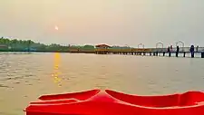    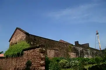 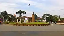 Clockwise from top: Vayalapra lake, Thalassery cuisine, St. Angelo Fort, Caltech Junction, Muzhappilangad Beach, Kannur International Airport. | |
| Nickname(s): Crown of Kerala | |
|
Location in Kerala | |
| Coordinates: 11.8689°N 75.35546°E | |
| Country | |
| State | Kerala |
| Established | 1957 |
| Headquarters | Kannur |
| Government | |
| • District Collector | T V Subhash. IAS |
| • District Police Chief | Yathish Chandra, IPS[1][2] |
| Area | |
| • Total | 2,966 km2 (1,145 sq mi) |
| Population (2018)[3] | |
| • Total | 2,615,266 |
| • Density | 882/km2 (2,280/sq mi) |
| Demonym(s) | Kannurian |
| Languages | |
| • Official | Malayalam, English |
| Time zone | UTC+5:30 (IST) |
| ISO 3166 code | IN-KL-KNR, IN-KL |
| Vehicle registration | KL-13, KL-58, KL-59,KL-78,KL-86 |
| Sex ratio | 1090 ♂/♀ |
| Literacy | 95.10% |
| Website | www |
Kannur is the sixth-most urbanised district in Kerala, with more than 50% of its residents living in urban areas. Kannur has an urban population of 1,640,986, which is the second largest in Kerala after Ernakulam district.[4][5] It was part of the Malabar District under the Madras province during the British Raj.
History
Kannur district was ruled by the Chera dynasty as per the recorded-history, from centuries before Christ till the medieval period, covered all of Kerala, Kanyakumari District and western Tamil Nadu.[6] The Mushika dynasty, also called the Nannans and later the Kolathiris, were relatives of the Cheras and ruled the Kannur-Wayanad-Kasaragod area (Kolathunadu) as their regents.[7][8][9] The Kannur region (Kolathunadu), as part of Cheranaadu (Chera Kingdom), traded for several centuries with ancient Greece and Rome.[10][11]
Kannur was an important trading center in the 12th century with active business connections with Persia and Arabia. It served as the British military headquarters on India's west coast until 1887. In conjunction with her sister city, Tellicherry, it was the third-largest city on the western coast of British India in the 18th century after Bombay and Karachi. St. Angelo Fort was built in 1505 by Dom Francisco de Almeida, the first Portuguese Viceroy of India. The Dutch captured the fort from the Portuguese in 1663. They modernized the fort and built the bastions Hollandia, Zeelandia, and Frieslandia that are the major features of the present structure. The original Portuguese fort was pulled down later. A painting of this fort and the fishing ferry behind it can be seen in the Rijksmuseum Amsterdam. The Dutch sold the fort to the king Ali Raja of Arakkal in 1772. The British conquered it in 1790 and used it as one of their major military stations on the Malabar Coast. During the 17th century, Kannur was the capital city of the only Muslim Sultanate in the Malabar region - Arakkal.[12] During the British Raj, Kannur was part of the Madras province in the Malabar District .
Demographics
| Year | Pop. | ±% p.a. |
|---|---|---|
| 1901 | 529,623 | — |
| 1911 | 565,261 | +0.65% |
| 1921 | 578,680 | +0.23% |
| 1931 | 662,715 | +1.37% |
| 1941 | 743,322 | +1.15% |
| 1951 | 904,470 | +1.98% |
| 1961 | 1,177,948 | +2.68% |
| 1971 | 1,552,809 | +2.80% |
| 1981 | 1,930,726 | +2.20% |
| 1991 | 2,251,727 | +1.55% |
| 2001 | 2,408,956 | +0.68% |
| 2011 | 2,523,003 | +0.46% |
| 2018 | 2,615,266 | +0.51% |
| source:[13] | ||
According to the 2018 Statistics Report, Kannur district has a population of 2,615,266,[3] The district has a population density of 882 inhabitants per square kilometre (2,280/sq mi).[14] Its population growth rate over the decade 2001-2011 was 4.84%.[14] The 2011 Census of India gives the district a ranking of 170th in India (out of a total of 640).[14] Kannur has a sex ratio of 1133 females for every 1000 males,[14] the highest among any district in India, and a literacy rate of 95.10%.[14]
The District has a population of 2,412,365 (2001 census). This was the most urbanised district in Kerala in 2001, but was pushed to 4th place after Ernakulam, Thrissur and Kozhikode in 2011.[15] About 50.35% of the population reside in the urban agglomerations. The total urban population of Kannur district is 1,640,986. This is the second largest urban population in Kerala after Ernakulam and is more than the population of a metro city.[16]
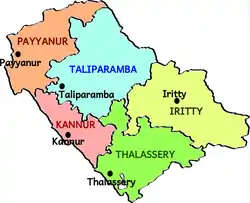
The high urban population is due to the 45 towns in the district which was the highest in Kerala as per 2001 census. 2011 census has Thrissur with 135 towns with Kannur having 67.[17] Kannur district has seven statutory towns: Kannur, Kannur Cantonment, Thalassery, Payyannur, Thaliparamba, Kuthuparamba and Mattannur. In addition to this there are 60 including Ancharakandy, Azhikode North, Azhikode South, Chala, Chelora, Cherukunnu, Cheruthazham, Chirakkal, Chockli, Dharmadom, Elayavoor, Eranholi, Iriveri, Kadachira, Kadirur, Kalliasseri, Kanhirode, Kannadiparamba, Kannapuram, Kottayam-Malabar, Mayyil, Mavilayi, Munderi, Muzhappilangad, Narath, New Mahe, Paduvilayi, Pallikkunnu, Panniyannur, Panoor, Pappinisseri, Pathiriyad, Pattiom, Iritty, Peralasseri, Peringathur, Pinarayi, Puzhathi, Thottada, Valapattanam, Varam.[15]
Religion

.jpg.webp)
Hinduism is the majority religion of Kannur district. Muslims and Christians form a significant minority.[18]
Most of the Christians in Kannur district are descendants of Christians who migrated to Malabar in the 20th century(Malabar Migration).[19]
Government and politics
Panoor, Kuthuparamba and Mattanur areas of Thalassery Taluk in the district have been a hub of political violence between the Communist Party of India (Marxist) (CPI(M)) and the Rashtriya Swayamsevak Sangh (RSS) combine. Clashes in 2008 left seven people killed and many have been injured. The High Court of Kerala called this manslaughter a “compelling sport” and suggested permanent deployment of Central forces in the affected areas.[20]
Education
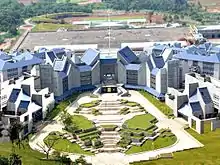
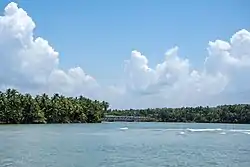
Tourism
Notable people
- E. Ahamed - former Minister of State for Railways
- Salim Ahamed - film director, screenwriter, film producer
- Ayyathan Janaki Ammal - first female doctor of Kerala
- Janaki Ammal - botanist
- Sukumar Azhikode - writer
- Ajit Balakrishnan - founder and current CEO of Rediff.com
- N. E. Balaram - one of the founding leaders of the communist movement in Kerala
- John Brittas - Journalist and Managing Director of Kairali TV
- Deepak Dev - music composer
- M. V. Devan - painter, sculptor, writer, art critic and orator
- Jimmy George - volleyball player
- A. K. Gopalan - politician, former leader of the Communist Party of India (Marxist)
- Ayyathan Gopalan - doctor, social reformer, philanthropist
- Gita Gopinath - chief economist of the International Monetary Fund
- T. Govindan - former Member of Parliament
- Ifthi - music composer
- E. P. Jayarajan - politician and current Industries and Sports Minister of Kerala State
- K. Karunakaran - former Chief Minister of Kerala and Indian National Congress leader
- Shamna Kasim - actor
- Santhosh Keezhattoor - actor
- Shajith Koyeri - sound designer
- Vineeth Kumar - actor
- T. P. Muhammad Kunhi, educationalist
- Major General CK Lakshmanan - first Malayali Olympian
- Sruthi Lakshmi - actor
- Tintu Luka - athlete
- V. K. Krishna Menon - Nationalist, diplomat, and politician
- K. U. Mohanan- director of photography
- Malavika Mohanan - actor
- Geetu Mohandas - actor
- Mamta Mohandas - actor
- V. Muraleedharan - Politician and the current union minister of state for external affairs and parliamentary affairs
- C. P. Krishnan Nair - businessman and founder of Leela group of hotels
- Bejoy Nambiar- director and screenwriter
- K. P. P. Nambiar - industrialist and technocrat
- M. N. Nambiar - actor
- Parvathy Nambiar - actor
- Kaithapram Damodaran Namboothiri - lyricist, music director, actor, singer, screenwriter, and performer of Carnatic music
- Unnikrishnan Namboothiri - actor
- Madhushree Narayan - playback singer
- Ramesh Narayan - music composer
- E. K. Nayanar - former three time Chief Minister of Kerala
- T. Padmanabhan - writer
- Deepak Parambol - actor
- Sayanora Philip- playback singer, music composer
- N. Prabhakaran - writer
- Azhikodan Raghavan - politician
- K. Raghavan - music composer
- M. V. Raghavan - former minister
- Shaan Rahman - music composer
- Pazhassi Raja - ruler of the Pazhassi Kingdom in present-day Kannur district
- Anaswara Rajan - actor
- Athmiya Rajan - actor
- Kannur Rajan - music composer
- T. V. Rajesh - politician
- Kadannappalli Ramachandran - Minister of Port of Kerala
- Moorkoth Ramunni - fighter pilot
- Neha Ratnakaran - actor
- Byju Raveendran - entrepreneur, founder of Byju's App
- Sreeja Ravi - voice-dubbing artist
- Sahal Abdul Samad - Footballer
- Sanjayan - writer
- Mattannoor Sankarankutty - percussionist
- Sanoop Santhosh - actor
- Sanusha - actor
- A. K. Saseendran - politician andcCurrent Transport Minister of Kerala State
- Mafia Sasi - film actor, stuntman
- V. P. Sathyan - footballer
- Roshan Sebastian - playback singer
- K. K. Shailaja - politician and current Minister of Health and Social Welfare of Kerala State
- Sushin Shyam - music composer
- P. K. Sreemathy - MP
- Sreenivasan - actor
- Dhyan Sreenivasan - actor
- Vineeth Sreenivasan - actor, singer, film director
- Samvrutha Sunil - actor
- Nivetha Thomas - actor
- Ashish Vidyarthi - actor
- Pinarayi Vijayan - former CPI(M) State Secretary and Chief Minister of Kerala.
- Nikhila Vimal - actor
- Vineeth - actor
- C.K. Vineeth - footballer
- Manju Warrier - actor (originally from Thrissur, lived in Kannur during her schooling)
See also
References
- "Who is Who". kannur.keralapolice.gov.in. Retrieved 11 January 2021.
- "Cases filed against Kannur mosques, temple for defying COVID-19 norms". The Hindu. 21 March 2020. Retrieved 25 March 2020.
- Annual Vital Statistics Report - 2018 (PDF). Thiruvananthapuram: Department of Economics and Statistics, Government of Kerala. 2020. p. 55.
- "Archived copy" (PDF). Archived from the original (PDF) on 28 November 2010. Retrieved 24 November 2010.CS1 maint: archived copy as title (link)
- "Untitled Document". Archived from the original on 25 July 2014. Retrieved 26 May 2009.
- https://books.google.co.in/books?id=omgMAQAAMAAJ Page 187
- https://books.google.co.in/books?id=pXpuAAAAMAAJ Page 219
- https://books.google.co.in/books?id=LGG1vE4TK6cC Page 135
- https://books.google.co.in/books?id=TDCKdPpbFPAC Page 287
- https://books.google.co.in/books?id=TjVuAAAAMAAJ Page 626
- https://books.google.co.in/books?id=J2DdDwAAQBAJ Page 8
- "Arakkal royal family". Archived from the original on 5 June 2012.
- "Census of India Website : Office of the Registrar General & Census Commissioner, India". www.censusindia.gov.in.
- "District Census 2011". Census2011.co.in. 2011. Retrieved 30 September 2011.
- "Census of India Website : Office of the Registrar General & Census Commissioner, India". Archived from the original on 14 May 2007.
- "Archived copy". Archived from the original on 11 January 2010. Retrieved 27 August 2009.CS1 maint: archived copy as title (link)
- http://www.censusindia.gov.in/2011-prov-results/paper2-vol2/data_files/kerala/Chapter_IV.pdf
- "Religion – Kerala, Districts and Sub-districts". Census of India 2011. Office of the Registrar General.
- Malabar Migration. "Reference to Malabar Migration" Archived 21 July 2011 at the Wayback Machine, ,
- "Only Centre can end Kannur violence: High Court". Chennai, India: The Hindu. 12 March 2008.
External links
| Wikimedia Commons has media related to Kannur district. |
| Wikivoyage has a travel guide for Kannur District. |