Houston Street station (IRT Broadway–Seventh Avenue Line)
Houston Street is a local station on the IRT Broadway–Seventh Avenue Line of the New York City Subway. Located at West Houston and Varick Streets in Greenwich Village, Manhattan, it is served by the 1 train at all times and by the 2 train during late nights.
Houston Street | ||||||||||||||||||||||||||||||||||||||||||||||||||||||||||||||||||||
|---|---|---|---|---|---|---|---|---|---|---|---|---|---|---|---|---|---|---|---|---|---|---|---|---|---|---|---|---|---|---|---|---|---|---|---|---|---|---|---|---|---|---|---|---|---|---|---|---|---|---|---|---|---|---|---|---|---|---|---|---|---|---|---|---|---|---|---|---|
 Uptown platform | ||||||||||||||||||||||||||||||||||||||||||||||||||||||||||||||||||||
| Station statistics | ||||||||||||||||||||||||||||||||||||||||||||||||||||||||||||||||||||
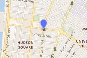
| Address | West Houston Street & Varick Street New York, NY 10014 | |||||||||||||||||||||||||||||||||||||||||||||||||||||||||||||||||||
| Borough | Manhattan | |||||||||||||||||||||||||||||||||||||||||||||||||||||||||||||||||||
| Locale | Greenwich Village, West Village, Hudson Square | |||||||||||||||||||||||||||||||||||||||||||||||||||||||||||||||||||
| Coordinates | 40.728592°N 74.005322°W | |||||||||||||||||||||||||||||||||||||||||||||||||||||||||||||||||||
| Division | A (IRT) | |||||||||||||||||||||||||||||||||||||||||||||||||||||||||||||||||||
| Line | IRT Broadway–Seventh Avenue Line | |||||||||||||||||||||||||||||||||||||||||||||||||||||||||||||||||||
| Services | 1 2 | |||||||||||||||||||||||||||||||||||||||||||||||||||||||||||||||||||
| Transit | ||||||||||||||||||||||||||||||||||||||||||||||||||||||||||||||||||||
| Structure | Underground | |||||||||||||||||||||||||||||||||||||||||||||||||||||||||||||||||||
| Platforms | 2 side platforms | |||||||||||||||||||||||||||||||||||||||||||||||||||||||||||||||||||
| Tracks | 4 | |||||||||||||||||||||||||||||||||||||||||||||||||||||||||||||||||||
| Other information | ||||||||||||||||||||||||||||||||||||||||||||||||||||||||||||||||||||
| Opened | July 1, 1918 | |||||||||||||||||||||||||||||||||||||||||||||||||||||||||||||||||||
| Station code | 324[1] | |||||||||||||||||||||||||||||||||||||||||||||||||||||||||||||||||||
| Opposite- direction transfer | No | |||||||||||||||||||||||||||||||||||||||||||||||||||||||||||||||||||
| Traffic | ||||||||||||||||||||||||||||||||||||||||||||||||||||||||||||||||||||
| 2019 | 4,496,793[2] | |||||||||||||||||||||||||||||||||||||||||||||||||||||||||||||||||||
| Rank | 107 out of 424[2] | |||||||||||||||||||||||||||||||||||||||||||||||||||||||||||||||||||
| Station succession | ||||||||||||||||||||||||||||||||||||||||||||||||||||||||||||||||||||
| Next north | Christopher Street–Sheridan Square: 1 | |||||||||||||||||||||||||||||||||||||||||||||||||||||||||||||||||||
| Next south | Canal Street: 1 | |||||||||||||||||||||||||||||||||||||||||||||||||||||||||||||||||||
| ||||||||||||||||||||||||||||||||||||||||||||||||||||||||||||||||||||
| ||||||||||||||||||||||||||||||||||||||||||||||||||||||||||||||||||||
| ||||||||||||||||||||||||||||||||||||||||||||||||||||||||||||||||||||
| ||||||||||||||||||||||||||||||||||||||||||||||||||||||||||||||||||||

History
The Dual Contracts, which were signed on March 19, 1913, were contracts for the construction and/or rehabilitation and operation of rapid transit lines in the City of New York. The contracts were "dual" in that they were signed between the City and two separate private companies (the Interborough Rapid Transit Company and the Brooklyn Rapid Transit Company), all working together to make the construction of the Dual Contracts possible. The Dual Contracts promised the construction of several lines in Brooklyn. As part of Contract 4, the IRT agreed to build a branch of the original subway line south down Seventh Avenue, Varick Street, and West Broadway to serve the West Side of Manhattan.[3][4][5]
The construction of this line, in conjunction with the construction of the Lexington Avenue Line, would change the operations of the IRT system. Instead of having trains go via Broadway, turning onto 42nd Street, before finally turning onto Park Avenue, there would be two trunk lines connected by the 42nd Street Shuttle. The system would be changed from looking like a "Z" system on a map to an "H" system. One trunk would run via the new Lexington Avenue Line down Park Avenue, and the other trunk would run via the new Seventh Avenue Line up Broadway. In order for the line to continue down Varick Street and West Broadway, these streets needed to be widened, and two new streets were built, the Seventh Avenue Extension and the Varick Street Extension.[6] It was predicted that the subway extension would lead to the growth of the Lower West Side, and to neighborhoods such as Chelsea and Greenwich Village.[7][8]
Houston Street opened as the line was extended south to South Ferry from 34th Street–Penn Station on July 1, 1918, and was served by a shuttle.[9] The new "H" system was implemented on August 1, 1918, joining the two halves of the Broadway–Seventh Avenue Line and sending all West Side trains south from Times Square.[10] An immediate result of the switch was the need to transfer using the 42nd Street Shuttle in order to retrace the original layout. The completion of the "H" system doubled the capacity of the IRT system.[7]
Station layout
| G | Street level | Exit/entrance |
| P Platform level |
Side platform | |
| Northbound local | ← ← | |
| Northbound express | ← | |
| Southbound express | | |
| Southbound local | | |
| Side platform | ||
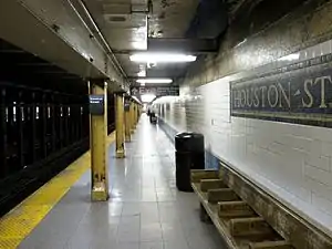
This underground station has two side platforms and four tracks. In a fashion similar to 33rd Street on the Lexington Avenue Line, the two center tracks appears to descend within the confines of the station. As a result, the express tracks are at a lower elevation than the local tracks in the northern half of the station. The center tracks are used by the 2 and 3 express trains during daytime hours.
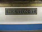
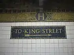
Both platforms have golden mosaic trim lines with blue and green borders and "H" tablets on a light blue background at regular intervals. The large name tablets read "HOUSTON ST." in gold Times New Roman font on dark blue background and gold border. There are also directional tablets in the same style. Yellow i-beam columns lining run along both platforms at regular intervals with alternating ones having the standard black name plate with white Helvetica lettering.
The station's artwork, installed during a 1994 in-house renovation, is entitled Platform Diving by Deborah Brown. It consists of murals on both platforms depicting sea creatures in an underwater subway system.
Exits
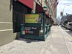
All fare control areas in this station are at platform level and there are no crossovers or crossunders. On both sides, a turnstile bank leads to a two staircases going up to West Houston and Varick Streets, either western corners on the South Ferry-bound side and either eastern corners on the Bronx-bound side. Only the Bronx-bound side has a token booth; the South Ferry-bound side is unstaffed.[11]
Both platforms have an unstaffed secondary fare control area towards their south ends. Two high entry/exit turnstiles and one exit-only turnstile leads to two staircases going up to Varick and King Streets, either western corners on the South Ferry-bound side and either eastern corners on the Bronx-bound side.[11]
References
- "Station Developers' Information". Metropolitan Transportation Authority. Retrieved June 13, 2017.
- "Facts and Figures: Annual Subway Ridership 2014–2019". Metropolitan Transportation Authority. 2020. Retrieved May 26, 2020.
- "Terms and Conditions of Dual System Contracts". nycsubway.org. Public Service Commission. March 19, 1913. Retrieved February 16, 2015.
- "The Dual System of Rapid Transit (1912)". nycsubway.org. Public Service Commission. September 1912. Retrieved May 30, 2017.
- "Most Recent Map of the Dual Subway System Which Shows How Brooklyn Borough Is Favored In New Transit Lines". The Brooklyn Daily Eagle. September 9, 1917. p. 37. Retrieved August 23, 2016 – via Brooklyn Public Library; newspapers.com.
- Engineering News-record. McGraw-Hill Publishing Company. 1916.
- Whitney, Travis H. (March 10, 1918). "The Seventh and Lexington Avenue Subways Will Revive Dormant Sections" (PDF). The New York Times. p. 12. ISSN 0362-4331. Retrieved August 26, 2016.
- "Public Service Commission Fixes July 15 For Opening of The New Seventh and Lexington Avenue Subway Lines" (PDF). The New York Times. May 19, 1918. p. 32. ISSN 0362-4331. Retrieved November 6, 2016.
- "Open New Subway to Regular Traffic" (PDF). The New York Times. July 2, 1918. p. 11. ISSN 0362-4331. Retrieved November 6, 2016.
- "Open New Subway Lines to Traffic; Called a Triumph" (PDF). The New York Times. August 2, 1918. p. 1. ISSN 0362-4331. Retrieved 2020-04-21.
- "MTA Neighborhood Maps: SoHo / Tribeca" (PDF). Metropolitan Transportation Authority. 2015. Retrieved August 6, 2015.
External links
| Wikimedia Commons has media related to Houston Street (IRT Broadway – Seventh Avenue Line). |
- nycsubway.org – IRT West Side Line: Houston Street
- nycsubway.org – Platform Diving Artwork by Deborah Brown (1994)
- Station Reporter – 1 Train
- MTA's Arts For Transit – Houston Street (IRT Broadway–Seventh Avenue Line)
- Houston Street entrance from Google Maps Street View
- King Street entrance from Google Maps Street View
- Platforms from Google Maps Street View