66th Street–Lincoln Center station
66th Street–Lincoln Center is a local station on the IRT Broadway–Seventh Avenue Line of the New York City Subway. Located at the intersection of 66th Street and Broadway in Lincoln Square, Manhattan, it is served by the 1 train at all times and by the 2 train during late nights.
66 Street–Lincoln Center | ||||||||||||||||||||||||||||||||||||||||||||||||||||||||||||||||||||
|---|---|---|---|---|---|---|---|---|---|---|---|---|---|---|---|---|---|---|---|---|---|---|---|---|---|---|---|---|---|---|---|---|---|---|---|---|---|---|---|---|---|---|---|---|---|---|---|---|---|---|---|---|---|---|---|---|---|---|---|---|---|---|---|---|---|---|---|---|
 Uptown platform | ||||||||||||||||||||||||||||||||||||||||||||||||||||||||||||||||||||
| Station statistics | ||||||||||||||||||||||||||||||||||||||||||||||||||||||||||||||||||||
| Address | West 66th Street & Broadway New York, NY 10023[1] | |||||||||||||||||||||||||||||||||||||||||||||||||||||||||||||||||||
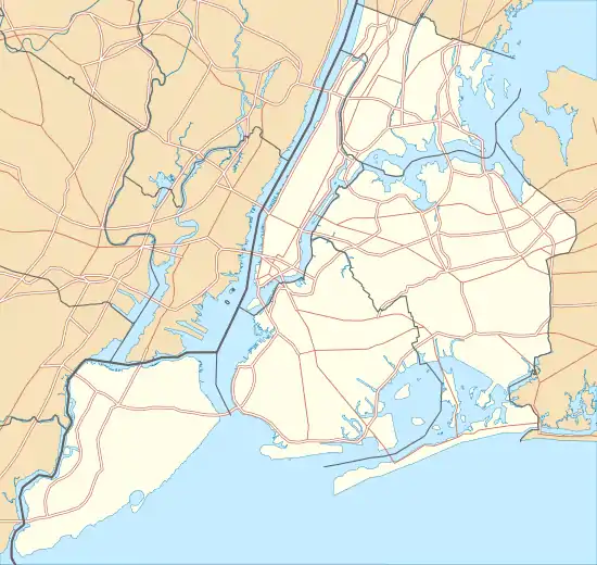
| Borough | Manhattan | |||||||||||||||||||||||||||||||||||||||||||||||||||||||||||||||||||
| Locale | Lincoln Square, Upper West Side | |||||||||||||||||||||||||||||||||||||||||||||||||||||||||||||||||||
| Coordinates | 40.774°N 73.982°W | |||||||||||||||||||||||||||||||||||||||||||||||||||||||||||||||||||
| Division | A (IRT) | |||||||||||||||||||||||||||||||||||||||||||||||||||||||||||||||||||
| Line | IRT Broadway–Seventh Avenue Line | |||||||||||||||||||||||||||||||||||||||||||||||||||||||||||||||||||
| Services | 1 2 | |||||||||||||||||||||||||||||||||||||||||||||||||||||||||||||||||||
| Transit | ||||||||||||||||||||||||||||||||||||||||||||||||||||||||||||||||||||
| Structure | Underground | |||||||||||||||||||||||||||||||||||||||||||||||||||||||||||||||||||
| Platforms | 2 side platforms | |||||||||||||||||||||||||||||||||||||||||||||||||||||||||||||||||||
| Tracks | 4 | |||||||||||||||||||||||||||||||||||||||||||||||||||||||||||||||||||
| Other information | ||||||||||||||||||||||||||||||||||||||||||||||||||||||||||||||||||||
| Opened | October 27, 1904[3] | |||||||||||||||||||||||||||||||||||||||||||||||||||||||||||||||||||
| Station code | 314[4] | |||||||||||||||||||||||||||||||||||||||||||||||||||||||||||||||||||
| Accessible | ||||||||||||||||||||||||||||||||||||||||||||||||||||||||||||||||||||
| Opposite- direction transfer | Yes | |||||||||||||||||||||||||||||||||||||||||||||||||||||||||||||||||||
| Traffic | ||||||||||||||||||||||||||||||||||||||||||||||||||||||||||||||||||||
| 2019 | 7,068,256[5] | |||||||||||||||||||||||||||||||||||||||||||||||||||||||||||||||||||
| Rank | 54 out of 424[5] | |||||||||||||||||||||||||||||||||||||||||||||||||||||||||||||||||||
| Station succession | ||||||||||||||||||||||||||||||||||||||||||||||||||||||||||||||||||||
| Next north | 72nd Street: 1 | |||||||||||||||||||||||||||||||||||||||||||||||||||||||||||||||||||
| Next south | 59th Street–Columbus Circle: 1 | |||||||||||||||||||||||||||||||||||||||||||||||||||||||||||||||||||
| ||||||||||||||||||||||||||||||||||||||||||||||||||||||||||||||||||||
| ||||||||||||||||||||||||||||||||||||||||||||||||||||||||||||||||||||
| ||||||||||||||||||||||||||||||||||||||||||||||||||||||||||||||||||||
| ||||||||||||||||||||||||||||||||||||||||||||||||||||||||||||||||||||


Built for the Interborough Rapid Transit Company (IRT), the 66th Street station was constructed as part of the city's first subway line, which was approved in 1900. Construction on the segment of the line that includes the 66th Street station started on August 22 of the same year. The station opened on October 27, 1904, as one of the original 28 stations of the New York City Subway. The station's platforms have been lengthened since opening.
The 66th Street station contains two side platforms and four tracks; express trains use the inner two tracks to bypass the station. The station was built with tile and mosaic decorations. The platforms contain exits to 66th Street and Broadway as well as to Lincoln Center. The station contains elevators from the street, which make it compliant with the Americans with Disabilities Act of 1990.
History
Construction and opening

Planning for the city's first subway line dates to the Rapid Transit Act, authorized by the New York State Legislature in 1894.[6]:139–140 The subway plans were drawn up by a team of engineers led by William Barclay Parsons, chief engineer of the Rapid Transit Commission. It called for a subway line from New York City Hall in lower Manhattan to the Upper West Side, where two branches would lead north into the Bronx.[7]:3 A plan was formally adopted in 1897, and legal challenges were resolved near the end of 1899.[6]:148 The Rapid Transit Construction Company, organized by John B. McDonald and funded by August Belmont Jr., signed Contract 1 with the Rapid Transit Commission in February 1900,[8] in which it would construct the subway and maintain a 50-year operating lease from the opening of the line.[6]:182 In 1901, the firm of Heins & LaFarge was hired to design the underground stations.[7]:4 Belmont incorporated the Interborough Rapid Transit Company (IRT) in April 1902 to operate the subway.[6]:182
The 66th Street station was constructed as part of the IRT's West Side Line (now the Broadway–Seventh Avenue Line) from 60th Street to 82nd Street, for which work had begun on August 22, 1900. Work for that section had been awarded to William Bradley.[8] The 66th Street station opened on October 27, 1904, as one of the original 28 stations of the New York City Subway from City Hall to 145th Street on the West Side Branch.[6]:186[3]
Service changes and station renovations
After the initial system was completed in 1908,[9] the station was served by local trains along both the West Side (now the Broadway–Seventh Avenue Line to Van Cortlandt Park–242nd Street) and East Side (now the Lenox Avenue Line). West Side local trains had their southern terminus at City Hall during rush hours and South Ferry at other times, and had their northern terminus at 242nd Street. East Side local trains ran from City Hall to Lenox Avenue (145th Street).[10] In 1918, the Broadway–Seventh Avenue Line opened south of Times Square–42nd Street, thereby dividing the original line into an "H" system, and all local trains were sent to South Ferry.[11]
In 1909, to address overcrowding, the New York Public Service Commission proposed lengthening platforms at stations along the original IRT subway.[12]:168 On January 18, 1910, a modification was made to Contracts 1 and 2 to lengthen station platforms to accommodate ten-car express and six-car local trains. In addition to $1.5 million (equivalent to $41.2 million in 2019) spent on platform lengthening, $500,000 (equivalent to $13,719,643 in 2019) was spent on building additional entrances and exits. It was anticipated that these improvements would increase capacity by 25 percent.[13]:15 Platforms at local stations, such as the 66th Street station, were lengthened by between 20 to 30 feet (6.1 to 9.1 m). Both platforms were extended to the north and south.[13]:110
The IRT routes were given numbered designations with the introduction of "R-type" rolling stock. The first such fleet, the R12, was put into service in 1948.[14] The Broadway/West Side route became known as the 1 and the Lenox Avenue route as the 3.[15] The original IRT stations north of Times Square could barely fit five- or six-car local trains depending on the configuration of the trains. Stations on the line from 50th Street to 96th Street, including this station but excluding the 91st Street station, had their platforms extended in the 1950s to accommodate ten-car trains as part of a $100 million rebuilding program. The platform extensions at the local stations were completed by early 1958.[16] Once the project was completed, all 1 trains became local and all 2 and 3 trains became express, and eight-car local trains began operation. Increased and lengthened service was implemented during peak hours on the 1 train on February 6, 1959.[17] Due to the lengthening of the platforms at 86th Street and 96th Street, the intermediate 91st Street station was closed on February 2, 1959, because it was too close to the other two stations.[18][16]
On November 29, 1962, a new entrance at the station opened, leading to the lobby of the Philharmonic (now David Geffen) Hall of Lincoln Center. The entrance led from the downtown platform of the station, but also provided access to the uptown platform by an underpass at the station's south end. This entrance was built as part of a $10.2 million underground complex by the New York City Parks Department for the Philharmonic Hall. The project was partially funded by a Federal grant, and the work was contracted out to Slattery Construction Company.[19]
In April 1988,[20] the New York City Transit Authority (NYCTA) unveiled plans to speed up service on the Broadway–Seventh Avenue Line through the implementation of a skip-stop service: the 9 train.[21] When skip-stop service started in 1989, it was only implemented north of 137th Street–City College on weekdays, and 66th Street was served by both the 1 and the 9.[22][23][24] Skip-stop service ended on May 27, 2005.[25][26]
During the late 20th century, the 66th Street station was renovated to designs by Lee Harris Pomeroy.[27]
Station layout
| G | Street level | Exit/entrance |
| P Platform level |
Side platform | |
| Northbound local | ← ← | |
| Northbound express | ← | |
| Southbound express | | |
| Southbound local | | |
| Side platform | ||
Like other local stations, 66th Street has four tracks and two side platforms. The two express tracks are used by the 2 train during daytime hours and the 3 train at all times.[28] The platforms were originally 200 feet (61 m) long, as at other local stations on the original IRT,[7]:4[29]:8 but as a result of the 1958–1959 platform extension, became 520 feet (160 m) long.[16]
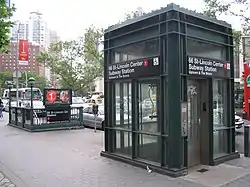
Elevators to street level provide ADA-accessibility. There is also a crossunder between the uptown and downtown side platforms at the extreme south end of the station; however, it is not ADA-accessible, and there is no free ADA-accessible transfer between directions.
Design


As with other stations built as part of the original IRT, the tunnel is covered by a "U"-shaped trough that contains utility pipes and wires. The bottom of this trough contains a foundation of concrete no less than 4 inches (100 mm) thick.[29]:9 Each platform consists of 3-inch-thick (7.6 cm) concrete slabs, beneath which are drainage basins. The original platforms contain circular, cast-iron Doric-style columns spaced every 15 feet (4.6 m), while the platform extensions contain I-beam columns. Additional columns between the tracks, spaced every 5 feet (1.5 m), support the jack-arched concrete station roofs.[7]:4[29]:9 There is a 1-inch (25 mm) gap between the trough wall and the platform walls, which are made of 4-inch (100 mm)-thick brick covered over by a tiled finish.[29]:9
The decorative scheme consists of yellow faience station-name tablets, buff tile bands, a yellow faience cornice, and blue faience plaques. The decorative work was performed by tile contractor Manhattan Glass Tile Company and faience contractor Grueby Faience Company.[29]:37 The ceilings of the original platforms and fare control areas contain plaster molding.[29]:10 The walls at the platform level were renovated in 2004 and are decorated with mosaics designed by New York artist Nancy Spero.

Exits
There are two staircases and one elevator on the southeastern corner of Broadway and 66th Street, leading to the northbound platform. Two staircases and one elevator on the southwestern corner of the same intersection lead to the southbound platform. Both sets of entrances and exits lead directly to their respective platform levels. A third set of exits, at the extreme south end of the southbound platform, contains a stair to the southwestern corner of Columbus Avenue and 65th Street, as well as a passageway to David Geffen Hall. This section of the station contains the crossunder.[30]
Nearby points of interest
| Buildings of Lincoln Center |
Buildings and structures in Lincoln Center: 1 2 3 4 5 6 7 8 9 10 11 12 13 |
The station provides access to Lincoln Center for the Performing Arts just to the south, with Alice Tully Hall just to the west. All of the Lincoln Center venues are connected by underground concourses near the southern end of the station. Dante Park, upstairs at the south end, is named for the poet Dante Alighieri, whose statue is found there. Richard Tucker Park is nearby, at the north end of Lincoln Square.[30]
A number of schools are nearby as well, including the Fiorello H. LaGuardia High School of Music & Art and Performing Arts and some small schools located in the former Martin Luther King Jr. High School building.[30]
This station also provides access to:[30]
- ABC Television Center East studios, and its affiliate WABC-TV
- American Folk Art Museum
- Amsterdam Houses, New York City Housing Authority
- The Beacon School
- Leonard Bernstein Way (W. 65th Street between Amsterdam Avenue and Broadway)
- Central Park
- Church of St. Paul the Apostle
- Church of the Good Shepherd
- Ethical Culture Fieldston School, Lower School
- Fordham University Lincoln Center campus
- Holy Trinity Church
- Peter Jennings Way (W. 66th Street between Columbus Avenue and Central Park West)
- Juilliard School
- Lincoln Center for the Performing Arts
- Lincoln Square farmers market (at Richard Tucker Square)
- Lincoln Square Synagogue
- Manhattan New York Temple (Mormon)
- Merkin Concert Hall
- Museum of Biblical Art (American Bible Society)
- New York Institute of Technology
- New York Society for Ethical Culture
- West Side YMCA
References
- "Borough of Manhattan, New York City". Government of New York City. Retrieved December 28, 2020.
- "Manhattan Bus Map" (PDF). Metropolitan Transportation Authority. July 2019. Retrieved December 1, 2020.
- "Our Subway Open: 150,000 Try It; Mayor McClellan Runs the First Official Train". The New York Times. October 28, 1904. p. 1. ISSN 0362-4331. Retrieved April 21, 2020.
- "Station Developers' Information". Metropolitan Transportation Authority. Retrieved June 13, 2017.
- "Facts and Figures: Annual Subway Ridership 2014–2019". Metropolitan Transportation Authority. 2020. Retrieved May 26, 2020.
- Walker, James Blaine (1918). Fifty Years of Rapid Transit — 1864 to 1917. New York, N.Y.: Law Printing. Retrieved November 6, 2016.
- "Interborough Rapid Transit System, Underground Interior" (PDF). New York City Landmarks Preservation Commission. October 23, 1979. Retrieved November 19, 2019.
- Report of the Board of Rapid Transit Railroad Commissioners for the City of New York For The Year Ending December 31, 1904 Accompanied By Reports of the Chief Engineer and of the Auditor. Board of Rapid Transit Railroad Commissioners. 1905. pp. 229–236.
- "Our First Subway Completed At Last — Opening of the Van Cortlandt Extension Finishes System Begun in 1900 — The Job Cost $60,000,000 — A Twenty-Mile Ride from Brooklyn to 242d Street for a Nickel Is Possible Now". The New York Times. August 2, 1908. p. 10. Retrieved November 6, 2016.
- Brooklyn Daily Eagle Almanac. Brooklyn Daily Eagle. 1916. p. 119.
- "Open New Subway Lines to Traffic; Called a Triumph" (PDF). The New York Times. August 2, 1918. p. 1. ISSN 0362-4331. Retrieved October 4, 2011.
- Hood, Clifton (1978). "The Impact of the IRT in New York City" (PDF). Historic American Engineering Record. pp. 146–207 (PDF pp. 147–208). Retrieved December 20, 2020.
 This article incorporates text from this source, which is in the public domain.
 - Report of the Public Service Commission for the First District of the State of New York For The Year Ending December 31, 1910. Public Service Commission. 1911.
- Brown, Nicole (May 17, 2019). "How did the MTA subway lines get their letter or number? NYCurious". amNewYork. Retrieved January 27, 2021.
- Friedlander, Alex; Lonto, Arthur; Raudenbush, Henry (April 1960). "A Summary of Services on the IRT Division, NYCTA" (PDF). New York Division Bulletin. Electric Railroaders' Association. 3 (1): 2–3.
- "High-Speed Broadway Local Service Began in 1959". The Bulletin. New York Division, Electric Railroaders' Association. 52 (2). February 2009. Retrieved August 26, 2016 – via Issuu.
- "Wagner Praises Modernized IRT — Mayor and Transit Authority Are Hailed as West Side Changes Take Effect". The New York Times. February 7, 1959. p. 21. ISSN 0362-4331. Retrieved November 6, 2016.
- Aciman, Andre (January 8, 1999). "My Manhattan — Next Stop: Subway's Past". The New York Times. ISSN 0362-4331. Retrieved August 26, 2016.
- "Philharmonic Hall Entrance To IRT Subway Opens Today". The New York Times. November 29, 1962. ISSN 0362-4331. Retrieved August 26, 2019.
- Brozan, Nadine (June 4, 1989). "'Skip-Stop' Subway Plan Annoys No. 1 Riders". The New York Times. ISSN 0362-4331. Retrieved June 15, 2016.
- Moore, Keith (June 10, 1988). "TA's skip-stop plan hit". New York Daily News. Retrieved November 8, 2018.
- "#1 Riders: Your Service is Changing". New York Daily News. August 20, 1989. Retrieved November 8, 2018.
- "Announcing 1 and 9 Skip-Stop Service on the Broadway-Seventh Avenue Line" (PDF). New York City Transit Authority. August 1989. Retrieved August 1, 2009.
- Lorch, Donatella (August 22, 1989). "New Service For Subways On West Side". The New York Times. ISSN 0362-4331. Retrieved June 15, 2016.
- Chan, Sewell (May 25, 2005). "On Its Last Wheels, No. 9 Line Is Vanishing on Signs". The New York Times. ISSN 0362-4331. Retrieved August 29, 2016.
- "Noteworthy - 9 discontinued". May 7, 2005. Archived from the original on May 7, 2005. Retrieved September 18, 2016.
- Fried, Joseph P. (2000-02-03). "Untangling Knots in the Subway; Architect's Challenge Is to Make DeKalb Station Flow". The New York Times. ISSN 0362-4331. Retrieved 2020-12-27.
- Dougherty, Peter (2006) [2002]. Tracks of the New York City Subway 2006 (3rd ed.). Dougherty. OCLC 49777633 – via Google Books.
- Framberger, David J. (1978). "Architectural Designs for New York's First Subway" (PDF). Historic American Engineering Record. pp. 1-46 (PDF pp. 367-412). Retrieved 2020-12-20. This article incorporates text from this source, which is in the public domain.
- "MTA Neighborhood Maps: Upper West Side" (PDF). mta.info. Metropolitan Transportation Authority. 2015. Retrieved December 30, 2016.
External links
| Wikimedia Commons has media related to 66th Street – Lincoln Center (IRT Broadway – Seventh Avenue Line). |
- nycsubway.org – IRT West Side Line: 66th Street/Lincoln Center
- nycsubway.org – Artemis, Acrobats, Divas and Dancers Artwork by Nancy Spero (2004)
- Station Reporter – 1 Train
- Forgotten NY – Original 28 – NYC's First 28 Subway Stations
- MTA's Arts For Transit–66th Street–Lincoln Center (IRT Broadway–Seventh Avenue Line)
- 66th Street entrance from Google Maps Street View
- 65th Street entrance from Google Maps Street View
- Platforms from Google Maps Street View