Hulan District
Hulan District (simplified Chinese: 呼兰区; traditional Chinese: 呼蘭區; pinyin: Hūlán Qū) is one of nine districts of the prefecture-level city of Harbin, the capital of Heilongjiang Province, Northeast China. It covers part of the northeastern suburbs. The district was approved to establish from the former Hulan County (呼兰县) by the Chinese State Council on February 4, 2004.[4] It borders Bayan County to the east, Bin County to the southeast, Daowai District to the south, and Songbei District to the southwest, as well as the prefecture-level city of Suihua to the northwest.
Hulan
呼兰区 | |
|---|---|
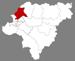 Location of Hulan in Harbin | |
.png.webp) Harbin in Heilongjiang | |
| Coordinates: 45°53′21″N 126°35′18″E[1] | |
| Country | People's Republic of China |
| Province | Heilongjiang |
| Sub-provincial city | Harbin |
| Area | |
| • Total | 2,185.9 km2 (844.0 sq mi) |
| Population (2010)[3] | |
| • Total | 764,534 |
| • Density | 350/km2 (910/sq mi) |
| Time zone | UTC+8 (China Standard) |
| Postal code | 1505XX |
| Website | hulan |
History
After World War II, the Hulan District was home of Manchukuo veterans who became homeless because they failed to conscript the newly People's Liberation Army.
See also
- Hulan River
- Tales of Hulan River, by Xiao Hong: a description of life in Hulan District, during the period 1910–1930.
References
- Google (2014-07-02). "Hulan" (Map). Google Maps. Google. Retrieved 2014-07-02.
- Harbin Statistical Yearbook 2011 (《哈尔滨统计年鉴2011》). Accessed 8 July 2014.
- 2010 Census Harbin primary statistics report (《哈尔滨市2010年第六次全国人口普查主要数据公报》). Accessed 8 July 2014.
- 国务院关于同意黑龙江省调整哈尔滨市部分行政区划的批复(国函〔2004〕10号) (in Chinese). gov.cn. 2004-02-04. Retrieved 2019-07-22.; (呼兰区)人文历史 (in Chinese). hulan.gov.cn. 2006-08-15. Retrieved 2019-07-22.
This article is issued from Wikipedia. The text is licensed under Creative Commons - Attribution - Sharealike. Additional terms may apply for the media files.