Huntingdon
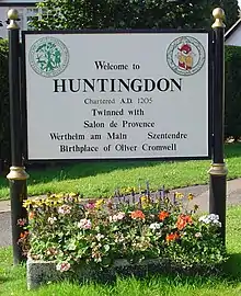
Huntingdon is a market town in Cambridgeshire, England, chartered by King John in 1205. Having been the county town of historic Huntingdonshire, it is now the seat of the Huntingdonshire District Council. It was the birthplace of Oliver Cromwell in 1599, who became its Member of Parliament (MP) in the 17th century. The former Conservative Prime Minister (1990–1997) John Major served as MP for Huntingdon from 1979 until his retirement in 2001.
| Huntingdon | |
|---|---|
| Market town | |
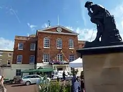 Old Town Hall and Thinking Soldier War Memorial | |
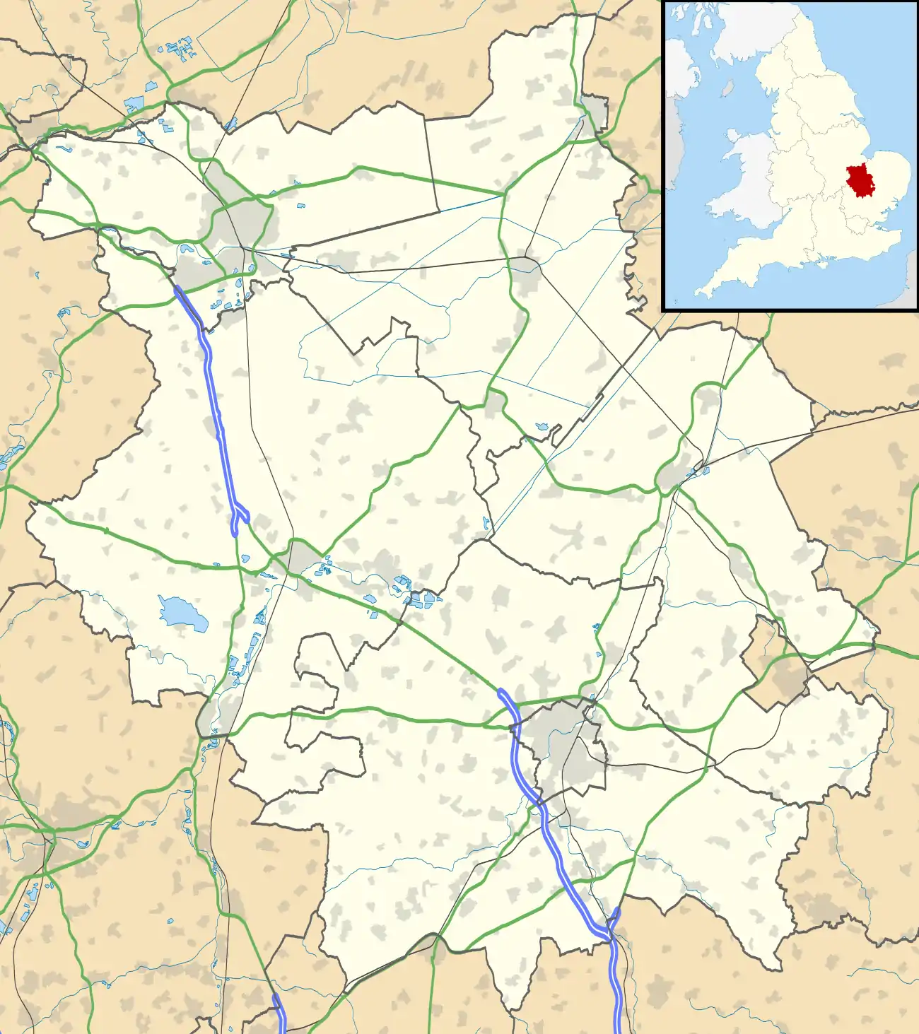 Huntingdon Location within Cambridgeshire | |
| Population | 23,732 2011 Census |
| OS grid reference | TL245725 |
| District | |
| Shire county | |
| Region | |
| Country | England |
| Sovereign state | United Kingdom |
| Post town | HUNTINGDON |
| Postcode district | PE26, PE28, PE29 |
| Dialling code | 01480 |
| Police | Cambridgeshire |
| Fire | Cambridgeshire |
| Ambulance | East of England |
| UK Parliament | |
History
Huntingdon was founded by the Anglo-Saxons and Danes. It is first mentioned in the Anglo-Saxon Chronicle in 921, where it appears as Huntandun. It appears as Huntedun in the Domesday Book of 1086. The name means "The huntsman's hill" or possibly "Hunta's hill".[1]
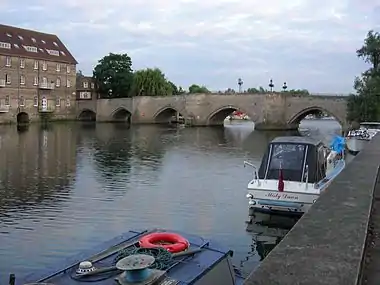
It seems that Huntingdon was a staging post for Danish raids outside of East Anglia until 917, when the Danes moved to Tempsford in Bedfordshire, before they were crushed by Edward the Elder. It prospered successively as a bridging point of the River Great Ouse, as a market town, and in the 18th and 19th centuries as a coaching centre, most notably the George Hotel. The town has a well-preserved medieval bridge that used to serve as the main route of Ermine Street over the river. The bridge only ceased to be the sole crossing point to Godmanchester in 1975, with the advent of what is now the A14 bypass.
Its valuable trading position was secured by Huntingdon Castle, of which only the earthworks of its motte survive. The site is now a Scheduled Ancient Monument and home to a beacon used to commemorate the 400th anniversary of the Spanish Armada.
In 1746, the botanists Wood and Ingram of nearby Brampton developed an elm-tree cultivar, Ulmus × hollandica 'Vegeta', which they named the "Huntingdon Elm" after the town.
Original documents on Huntingdon's history, including the borough charter of 1205, are held by Cambridgeshire Archives and Local Studies at the County Record Office, Huntingdon.[2]
Parts of Huntingdon, including the town centre, were struck by an F1/T3 tornado on 23 November 1981, during a record-breaking nationwide tornado outbreak on that day.[3] Moderate damage resulted in Huntingdon town centre.
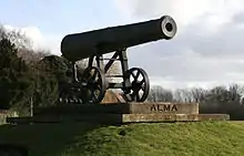
Between the railway station and the old hospital building stands a replica cannon installed in the 1990s to replace one from the Crimean War, scrapped for the war effort in the Second World War. However, it faces in the opposite direction from the original. St Mary's Street drill hall was built in the late 19th century.[4]
George Hotel
The George Hotel on the corner of High Street and George Street was once a posting house. It was named after St George in 1574 and bought some 25 years later by Henry Cromwell, grandfather of Oliver Cromwell. Charles I made the George Hotel his headquarters in 1645. Later the highwayman Dick Turpin is said to have been a visitor, when it was a coaching inn on the Great North Road. Two wings of the inn were burnt down in the mid-19th century, but two were saved, including one with a balcony overlooking the yard. Since 1959 the courtyard and balcony have been used for Shakespeare performances produced by the company run by the Shakespeare at the George Trust.[5]
Government
Huntingdon has a town council with 19 councillors, as elsewhere elected every four years.[6] Two of the councillors serve also as mayor and deputy mayor.[7] Meetings are normally held once a month at the town hall.[8]
Huntingdonshire District Council has three wards: Huntingdon North, Huntingdon East and Huntingdon West.[9] The Huntingdon East ward is represented by three councillors and the other wards by two each.[10] The main offices of Huntingdonshire District Council are in Huntingdon itself.
The highest tier of local government is Cambridgeshire County Council based in Cambridge, providing county-wide services such as major road infrastructure, fire and rescue, education, social services, libraries and heritage protection.[11] Huntingdon is one of 60 electoral divisions[9] and represented by two county councillors.[12]
Huntingdon lies in the parliamentary constituency of Huntingdon.[9] It has been represented by Jonathan Djanogly MP (Conservative) since 2001. The previous member was the former prime minister John Major (Conservative), who held the seat in 1979–2001.
Geography
The town lies on the north bank of the River Great Ouse, opposite Godmanchester and close to the market town of St Ives to the east and the village of Brampton to the west. Huntingdon now incorporates the village of Hartford to the east and the developing areas of Oxmoor, Stukeley Meadows and Hinchingbrooke to the north and west.
Between Godmanchester, Huntingdon and Brampton lies Portholme Meadow, England's largest.[13] About 257 acres (104 hectares) in area, it contains many rare species of grass, flowers and dragonfly. It is the only known British habitat of the marsh dandelion. It acts as a natural reservoir for water in times of flood, enabling the river to run off slowly, so helping to preclude flooding in nearby towns. It has also served as a horse racecourse and once was a centre for aviation.
Business
Huntingdon is home to many local businesses, including Huntingdon Racecourse. Hinchingbrooke Business Park has many offices and warehouses located in it.
Climate
The nearest weather station for which long-term weather data is available is RAF Wyton, 3 mi (5 km) north-east of the town centre, although more recently Monks Wood, 5 mi (8 km) to the north-west, has also provided data.
Like most of Britain, Huntingdon has a temperate maritime-based climate free from temperature extremes, with rainfall spread fairly evenly over the year. The absolute maximum recorded at Wyton was 35.4 °C (95.7 °F)[14] in August 1990; the temperature at Monks Wood rose in July 2006 to 35.1 °C (95.2 °F).[15] Typically the warmest day of the year averages 29.7 °C (85.5 °F).[16] and 16.0 days a year [17] will rise to 25.1 °C (77.2 °F) or above.
Typically 43.2 nights[18] of the year report an air frost. The absolute minimum at Wyton was −16.1 °C (3.0 °F)[19] recorded in January 1982. On average, the coldest night of the year will fall to −7.7 °C (18.1 °F)[20]
With annual rainfall at under 550 millimetres (21 1⁄2 inches) a year,[21] the Huntingdon area is among the driest in the UK – 103.4 days on average record at least 1 mm of rain.[22] All averages mentioned refer to the period 1971–2000.
Demography
Population
Between 1801 to 1901, the current area of Huntingdon town consisted of four parishes: Huntingdon All Saints, Huntingdon St Benedict, Huntingdon St John and Huntingdon St Mary. The populations of these were recorded in the ten-year UK census. The combined population in the period ranged between 2,368 in 1801 and 4,735 in 1891.[23] (The census was omitted in 1941.)
| Parish |
1911 |
1921 |
1931 |
1951 |
1961 |
1971 |
1981 |
1991 |
2001 |
2011 |
|---|---|---|---|---|---|---|---|---|---|---|
| Huntingdon | 4,464 | 4,644 | 4,570 | 5,282 | 14,648 | 15,451 | 20,099 | 23,732 | ||
All population census figures are taken from the report Historic Census figures Cambridgeshire to 2011 by Cambridgeshire Insight.[23] For the census taken in 1961 and that in 1971, Huntingdon was combined with Godmanchester.
In 2011, the parish covered an area of 2,765 acres (1,119 hectares).[23] The population density in that year was 5,493.1 inhabitants per square mile (2,120.9 inhabitants per square kilometre).
Culture and community
The former Literary and Scientific Institute is now Commemoration Hall.
There are three RAF stations within 4 mi (6 km) of the town: RAF Brampton, once home to Headquarters RAF Support Command and now part of the Defence Logistics Organisation (DLO); RAF Wyton, once a major flying station but now also part of the DLO; and RAF Alconbury currently occupied by the United States Air Force.
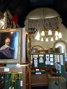
Part of the medieval infirmary hall of St Johns in the market place became Huntingdon Grammar School and was attended by Cromwell and by the diarist Samuel Pepys. The building is now the Cromwell Museum, run by Cambridgeshire County Council.
Legends
Once a convent, Hinchingbrooke House is said to be haunted. The bridge over the Alconbury Brook named Nun's Bridge[24] is said also to be haunted, by one of the nuns who once lived at the old convent that is now Hinchingbrooke House. She is said often to be accompanied by another ghost that resembles a nurse. The myth goes that the nun had a lover, a monk who caused them to be murdered. In 1965 a married couple reported seeing the ghosts on the bridge, and again when they returned home the same night.
Education
The local primary schools include Hartford Junior School, Huntingdon Primary School, Thongsley Fields Primary School, St John's Primary School, Stukeley Meadows Primary School and Cromwell Academy Primary School. Special-needs schools include Spring Common School. Secondary schools include St Peter's School and Hinchingbrooke School. Further Education colleges include Huntingdonshire Regional College, Hinchingbrooke School sixth-form college and St Peter's Sixth Form.
Transport
Rail
Huntingdon railway station has direct services to London Kings Cross station. It is served by Great Northern.
Bus
There are direct bus services to Peterborough, St Neots, Ramsey, St Ives and Cambridge, and also within the town and to Hinchingbrooke Hospital. Most buses are provided by Stagecoach East and Whippet.
Religious sites
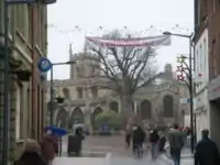
Once renowned for many more churches within the town, there are now four Church of England churches in Huntingdon, which together with the churches in the adjacent villages Great and Little Stukeley are members of the Huntingdon Team Ministry[25] in the Diocese of Ely. The four are All Saints' (next to the Market Square), St Mary's (opposite Pathfinder House), St Barnabas (on the Oxmoor estate) and All Saints', Hartford.
Huntingdon Methodist Church is situated on the High Street.[26] Medway Christian Fellowship is based on Medway Road.[27]
Sport
The town's highest ranked football club, Huntingdon Town, plays in the United Counties League, whilst Huntingdon United RGE plays in the Cambridgeshire League.
Notable residents
Names are in birth order. Data are from the subject's Wikipedia article except where referenced.
Arts and entertainment
- Henry Compton (Charles Mackenzie, 1805–1877), actor, born in Huntingdon
- George Mackley (1900–1983), wood engraver, born in Huntingdon
- Terry Reid, (born 1949), rock vocalist and guitarist, born in Huntingdon
- The Charlottes (formed 1988), indie rock band formed in Huntingdon.
- Ceara O'Neill (born 1990), actor and musician, born in Huntingdon
- Himesh Patel (born 1990), actor, born in Huntingdon
Literature
- Henry of Huntingdon (c. 1088–1157), historian (Historia Anglorum) and Archdeacon of Huntingdon
- Samuel Pepys (1633–1703), diarist, attended Huntingdon Grammar School in about 1644.
- Basil Montagu (1770–1851), jurist, barrister, writer and philanthropist, and illegitimate son of John Montagu, 4th Earl of Sandwich and Martha Ray
- Robert Carruthers (1799–1878), local historian (History of Huntingdon) and journalist
Religion
- Christina of Markyate (c. 1096–98 – c. 1155), anchoress and prioress, was born in Huntingdon.
Politics
- David, Earl of Huntingdon (c. 1144–1219), Scottish prince, was born in Huntingdon.[28]
- Richard Patrick (died 1566), MP for Huntingdon in 1559
- Oliver Cromwell (1599–1658), Lord Protector, was born in Huntingdon.
- Edward Montagu, 1st Earl of Sandwich (1625–1672), English Civil War general and Restoration politician, attended Huntingdon Grammar School.[29]
- Richard Cromwell (1626–1712), Lord Protector (1658–59), was born in Huntingdon.
- Henry Cromwell (1628–1674), Lord Deputy of Ireland and chancellor of Trinity College, Dublin, was born in Huntingdon.
- Charlie Elphicke (born 1971), Conservative member of Parliament, was born in Huntingdon.
Science and engineering
- Michael Foster (1836–1907), physiologist and academic, was born in Huntingdon.
- Robert William Edis (1839–1927), architect and writer on decoration, was born in Huntingdon and educated at Huntingdon Grammar School.
- Walter Samuel Millard (1864–1952), naturalist and conservationist, was born in Huntingdon.
- John Hilton Grace (1873–1958), neurologist and Fellow of the Royal Society, died in Huntingdon.
Sports
- Walter Yarnold (1893–1978), first-class cricketer, was born in Huntingdon
- Josh Gifford, (1941–2012), National Hunt jockey and trainer, was born in Huntingdon.
- Oliver Gavin (born 1972), racing car driver, was born in Huntingdon.
- Charlotte Edwards (born 1979), international women's cricketer, was born in Huntingdon.
- Darren Bent (born 1984), footballer, was raised in Huntingdon.
- Harriet Lee (born 1991), Paralympic swimmer, was born in Huntingdon.
- James Sykes (born 1992), first-class cricketer, born in Huntingdon
- James Kettleborough (born 1992), first-class cricketer, was born in Huntingdon.
- Alex Martin (born 1992), first-class cricketer, was born in Huntingdon.
- Todd Kane (born 1993), footballer, was born in Huntingdon.[30]
- George Furbank (born 1996), England international professional rugby union player was born in Huntingdon
International relations
Twin towns
 Salon de Provence, France
 Szentendre, Hungary
 Wertheim am Main, Germany
 Gubbio, Italy
 Kuala Kubu Baharu, Malaysia
See also
References
- Eilert Ekwall, The Concise Oxford Dictionary of English Place-names, p. 258.
- "Archived copy". Archived from the original on 23 December 2008. Retrieved 30 March 2009.CS1 maint: archived copy as title (link) cambridgeshire.gov.uk
- "European Severe Weather Database".
- "The Huntingdonshire Cyclist Battalions 1914–1919". Porch Museum. Retrieved 20 September 2017.
- "Shakespeare at the George". www.satg.org.uk. Retrieved 19 November 2017.
- "Huntingdon Town Council: Councillors". www.huntingdontown.gov.uk. Huntingdon Town Council. Retrieved 8 February 2016.
- "Huntingdon Town Council: Mayor of Huntingdon". www.huntingdontown.gov.uk. Huntingdon Town Council. Retrieved 8 February 2016.
- "Huntingdon Town Council: council meetings". www.huntingdontown.gov.uk. Huntingdon Town Council. Retrieved 8 February 2016.
- "Ordnance Survey Election Maps". www.ordnancesurvey.co.uk. Ordnance Survey. Retrieved 4 February 2016.
- "Huntingdonshire District Council: Councillors". www.huntsdc.gov.uk. Huntingdonshire District Council. Retrieved 4 February 2016.
- "Cambridgeshire County Council". www.cambridgeshire.gov.uk. Cambridgeshire County Council. Retrieved 23 February 2016.
- "Cambridgeshire County Council: Councillors". www.cambridgeshire.gov.uk. Cambridgeshire County Council. Archived from the original on 22 February 2016. Retrieved 15 February 2016.
- http://www.huntingdon-town.info/portholme.htm huntingdon-town.info
- "> 1990 Maximum". Retrieved 25 February 2011.
- "> July 2006". Archived from the original on 29 June 2011. Retrieved 25 February 2011.
- "> The mean annual warmest day". Retrieved 25 February 2011.
- ">25c days". Retrieved 25 February 2011.
- "air frost incidence". Retrieved 25 February 2011.
- "1982 minimum". Retrieved 25 February 2011.
- "Mean annual coldest night". Retrieved 25 February 2011.
- "Annual average rainfall". Retrieved 25 February 2011.
- "Annual average wetdays". Retrieved 25 February 2011.
- "Historic Census figures Cambridgeshire to 2011". www.cambridgeshireinsight.org.uk. Cambridgeshire Insight. Archived from the original (xlsx – download) on 15 February 2016. Retrieved 12 February 2016.
- http://www.francisfrith.com/huntingdon/photos/nuns-bridge-1901_46623/ francisfrith.com
- http://www.huntingdonanglicanchurches.org.uk huntingdonanglicanchurches.org.uk
- "Home". Huntingdon Methodist Church. Retrieved 19 November 2017.
- "Medway Christian Fellowship – Love Oxmoor – A church in the heart of the community". loveoxmoor.org.uk. Retrieved 19 November 2017.
- Rootsweb Retrieved 11 March 2016.
- BCW Project Retrieved 12 March 2016.
- Chelsea info Retrieved 8 January 2016.
External links
| Wikimedia Commons has media related to Huntingdon, Cambridgeshire. |
 Huntingdon travel guide from Wikivoyage
- Huntingdonshire District Council
- Huntingdon Town Council
| Authority control |
|---|