Hurt, Virginia
Hurt is a town in Pittsylvania County, Virginia, United States. Population was 1,304 at the 2010 census. It is included in the Danville, Virginia Metropolitan Statistical Area.
Hurt, Virginia | |
|---|---|
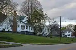 Houses on Prospect Road | |
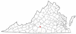 Location of Hurt, Virginia | |
| Coordinates: 37°5′42″N 79°17′54″W | |
| Country | United States |
| State | Virginia |
| County | Pittsylvania |
| Government | |
| • Type | Council-Manager |
| • Mayor | Gary Poindexter |
| • Town Council | Collin Adams Jeffery Bowling Rainy Clay Steve Watson Shirley Barksdale-Hill Gary Hodnett |
| Area | |
| • Total | 3.51 sq mi (9.10 km2) |
| • Land | 3.48 sq mi (9.00 km2) |
| • Water | 0.04 sq mi (0.09 km2) |
| Elevation | 748 ft (228 m) |
| Population (2010) | |
| • Total | 1,304 |
| • Estimate (2019)[2] | 1,223 |
| • Density | 351.84/sq mi (135.84/km2) |
| Time zone | UTC-5 (Eastern (EST)) |
| • Summer (DST) | UTC-4 (EDT) |
| ZIP code | 24563 |
| Area code(s) | 434 |
| FIPS code | 51-39224[3] |
| GNIS feature ID | 1468433[4] |
| Website | Official website |
History
The community bears the name of Colonel John R. Hurt, an early citizen.[5]
Hill Grove School and Locust Hill are listed on the National Register of Historic Places.[6]
Geography
According to the United States Census Bureau, the town has a total area of 2.6 square miles (6.8 km2), all of it land.
Demographics
| Historical population | |||
|---|---|---|---|
| Census | Pop. | %± | |
| 1970 | 1,434 | — | |
| 1980 | 1,481 | 3.3% | |
| 1990 | 1,294 | −12.6% | |
| 2000 | 1,276 | −1.4% | |
| 2010 | 1,304 | 2.2% | |
| 2019 (est.) | 1,223 | [2] | −6.2% |
| U.S. Decennial Census[7] | |||
As of the census[3] of 2000, there were 1,276 people, 541 households, and 385 families living in the town. The population density was 487.2 people per square mile (188.0/km2). There were 592 housing units at an average density of 226.0 per square mile (87.2/km2). The racial makeup of the town was 86.52% White, 12.07% African American, 0.16% Native American, 0.39% Asian, 0.31% from other races, and 0.55% from two or more races. Hispanic or Latino of any race were 0.94% of the population.
There were 541 households, out of which 29.2% had children under the age of 18 living with them, 56.4% were married couples living together, 11.8% had a female householder with no husband present, and 28.7% were non-families. 24.8% of all households were made up of individuals, and 11.6% had someone living alone who was 65 years of age or older. The average household size was 2.36 and the average family size was 2.80.
In the town, the population was spread out, with 21.7% under the age of 18, 6.9% from 18 to 24, 28.4% from 25 to 44, 25.3% from 45 to 64, and 17.7% who were 65 years of age or older. The median age was 41 years. For every 100 females there were 87.6 males. For every 100 females age 18 and over, there were 86.7 males.
The median income for a household in the town was $36,467, and the median income for a family was $40,938. Males had a median income of $29,219 versus $21,675 for females. The per capita income for the town was $16,875. About 9.3% of families and 10.7% of the population were below the poverty line, including 17.6% of those under age 18 and 13.0% of those age 65 or over.
Notable person
- Stacy Compton, NASCAR driver
References
- "2019 U.S. Gazetteer Files". United States Census Bureau. Retrieved August 7, 2020.
- "Population and Housing Unit Estimates". United States Census Bureau. May 24, 2020. Retrieved May 27, 2020.
- "U.S. Census website". United States Census Bureau. Retrieved 2008-01-31.
- "US Board on Geographic Names". United States Geological Survey. 2007-10-25. Retrieved 2008-01-31.
- Moyer, Armond; Moyer, Winifred (1958). The origins of unusual place-names. Keystone Pub. Associates. p. 65.
- "National Register Information System". National Register of Historic Places. National Park Service. July 9, 2010.
- "Census of Population and Housing". Census.gov. Retrieved June 4, 2015.