Pound, Virginia
Pound is a town in Wise County, Virginia, United States. The population was recorded as 1,037 in the 2010 United States Census.
Pound, Virginia | |
|---|---|
 Main Street | |
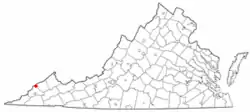 Location in the Commonwealth of Virginia | |
| Coordinates: 37°7′26″N 82°36′28″W | |
| Country | United States |
| State | Virginia |
| County | Wise |
| Government | |
| • Mayor | Stacey Carson |
| Area | |
| • Total | 2.61 sq mi (6.75 km2) |
| • Land | 2.60 sq mi (6.75 km2) |
| • Water | 0.00 sq mi (0.01 km2) |
| Elevation | 1,565 ft (477 m) |
| Population (2010) | |
| • Total | 1,037 |
| • Estimate (2019)[2] | 918 |
| • Density | 352.40/sq mi (136.04/km2) |
| Time zone | UTC-5 (EST) |
| • Summer (DST) | UTC-4 (EDT) |
| ZIP code | 24279 |
| Area code(s) | 276 |
| FIPS code | 51-64272[3] |
| GNIS feature ID | 1499906[4] |
| Website | http://www.poundva.com/ |
History
The Flat Gap High School and Sunnydale Farm are listed on the National Register of Historic Places.[5]
Author and motivational speaker Napoleon Hill was born in Pound in 1883.[6]
On November 30, 1927, Leonard Woods, a black coal miner and resident of Jenkins, Kentucky, was lynched on the Virginia-Kentucky border in Pound, Virginia. Woods had been jailed in Kentucky for the murder of 29-year-old Herschel Deaton of Coeburn, Virginia, following an altercation on November 27.[7] On the night of the lynching, a crowd estimated between 400-500 surrounded the Kentucky jail Woods was held in and demanded he be released to their custody. The crowd then transported Woods to a wooden structure located in Pound adjacent to the recently constructed US 23 highway. By this time the mob, estimated at 1,500, oversaw the hanging of Woods, followed by the firing of over 500 shots at his body, according to a local reporter. Both Virginia and Kentucky authorities claimed they were not responsible for investigating the crime, and no one was prosecuted for the death of Leonard Woods.[8]
Edith Maxwell was convicted in 1935 of murdering her father, Trigg Maxwell. She was pardoned in 1941 after appeals from Eleanor Rooosevelt and the Washington Post raised funds for her legal defense.
Geography
Pound is located at 37°7′26″N 82°36′28″W (37.123820, -82.607859).[9]
According to the United States Census Bureau, the town has a total area of 2.6 square miles (6.8 km2), all land.
Demographics
| Historical population | |||
|---|---|---|---|
| Census | Pop. | %± | |
| 1950 | 1,193 | — | |
| 1960 | 1,135 | −4.9% | |
| 1970 | 995 | −12.3% | |
| 1980 | 1,086 | 9.1% | |
| 1990 | 995 | −8.4% | |
| 2000 | 1,089 | 9.4% | |
| 2010 | 1,037 | −4.8% | |
| 2019 (est.) | 918 | [2] | −11.5% |
| U.S. Decennial Census[10] | |||
At the 2000 census there were 1,089 people, 455 households and 322 families in the town. The population density was 417.6 per square mile (161.1/km2). There were 516 housing units at an average density of 197.9 per square mile (76.3/km2). The racial makeup of the town was 98.71% White, 0.09% Native American, 0.09% from other races, and 1.10% from two or more races. Hispanic or Latino of any race were 0.18%.[3]
Of the 455 households 31.2% had children under the age of 18 living with them, 52.5% were married couples living together, 15.8% had a female householder with no husband present, and 29.2% were non-families. 25.9% of households were one person and 14.3% were one person aged 65 or older. The average household size was 2.39 and the average family size was 2.88.
The age distribution was 24.0% under the age of 18, 8.8% from 18 to 24, 29.8% from 25 to 44, 21.5% from 45 to 64, and 16.0% 65 or older. The median age was 39 years. For every 100 females there were 87.8 males. For every 100 females age 18 and over, there were 80.8 males.
The median income for a household in the town was $29,107, and the median family income was $33,688. Males had a median income of $32,065 versus $22,143 for females. The per capita income for the town was $14,375. About 19.4% of families and 23.0% of the population were below the poverty line, including 37.9% of those under age 18 and 9.8% of those age 65 or over.
Education
Pound has one public school: James Woodrow Adams Combined School.[11]
Highways
US 23 runs through Pound and crosses into Kentucky at Pound Gap. Pound is also the proposed connection to US 23 for the planned Coalfield Expressway.
Places of interest
Notable residents
- Glen Roberts - Professional Basketball Player
- Francis Gary Powers - Central Intelligence Agency Pilot
- Napoleon Hill - Author
- Tony Mullins - Songwriter
- Sean Brock - Chef
Notable acts
The town council adopted an ordinance forbidding dancing without a permit (Section 127-138). When the town turned down a dance application, the ordinance was challenged and overturned by the federal District Court in 1999 as "unconstitutional on its face."[12]
Climate
The climate in this area is characterized by relatively high temperatures and evenly distributed precipitation throughout the year. The Köppen Climate System describes the weather as humid subtropical, and uses the abbreviation Cfa.[13]
References
- "2019 U.S. Gazetteer Files". United States Census Bureau. Retrieved August 7, 2020.
- "Population and Housing Unit Estimates". United States Census Bureau. May 24, 2020. Retrieved May 27, 2020.
- "U.S. Census website". United States Census Bureau. Retrieved 2008-01-31.
- "US Board on Geographic Names". United States Geological Survey. 2007-10-25. Retrieved 2008-01-31.
- "National Register Information System". National Register of Historic Places. National Park Service. July 9, 2010.
- http://www.tom2tall.com/Pound-Virginia.html
- "Leonard Woods in Wise Racial Terror: Lynching in Virginia, 1877-1927". Retrieved 2019-06-22.
- Leidholdy, Alexander (Winter 2011). ""NEVER THOT THIS COULD HAPPEN IN THE SOUTH!" THE ANTI-LYNCHING ADVOCACY OF APPALACHIAN NEWSPAPER EDITOR BRUCE CRAWFORD". Appalachian Journal. 38 (2/3): 198–232. JSTOR 41320297.
- "US Gazetteer files: 2010, 2000, and 1990". United States Census Bureau. 2011-02-12. Retrieved 2011-04-23.
- "Census of Population and Housing". Census.gov. Retrieved June 4, 2015.
- "Archived copy". Archived from the original on 2013-05-18. Retrieved 2006-11-12.CS1 maint: archived copy as title (link)
- http://www.grunge.com/26819/weirdest-local-laws-us/s/dancing-in-pound-virginia/
- Climate Summary for Pound, Virginia
Municipalities and communities of Wise County, Virginia, United States | ||
|---|---|---|
| Towns |  Map of Virginia highlighting Wise County | |
| CDP | ||
| Unincorporated communities | ||
| Footnotes | ‡This populated place also has portions in an adjacent county or counties | |
| ||