Bridgewater, Virginia
Bridgewater is an incorporated town in Rockingham County, Virginia, United States. The population was 5,644 at the 2010 census. It is included in the Harrisonburg, Virginia Metropolitan Statistical Area. Bridgewater is also home to Bridgewater College.
Bridgewater, Virginia | |
|---|---|
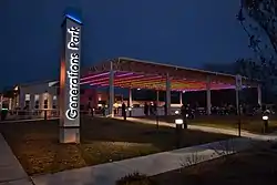 Generations Park in Bridgewater, Virginia | |
| Motto(s): Inter Se Succurrimus ("Enriching One Another") | |
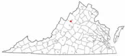 Location in Virginia | |
| Coordinates: 38°23′12″N 78°58′11″W | |
| Country | United States |
| State | Virginia |
| County | Rockingham |
| Founded | 1835 |
| Government | |
| • Mayor | Ted Flory |
| Area | |
| • Total | 2.52 sq mi (6.54 km2) |
| • Land | 2.52 sq mi (6.53 km2) |
| • Water | 0.01 sq mi (0.01 km2) |
| Elevation | 1,178 ft (359 m) |
| Population (2010) | |
| • Total | 5,644 |
| • Estimate (2019)[2] | 6,145 |
| • Density | 2,439.46/sq mi (941.70/km2) |
| Time zone | UTC−5 (Eastern (EST)) |
| • Summer (DST) | UTC−4 (EDT) |
| ZIP code | 22812 |
| Area code(s) | 540 |
| FIPS code | 51-09656[3] |
| GNIS feature ID | 1492628[4] |
| Website | Official website |
New Resident Information
The Town has published a welcome video and an informational website for people moving to the Town, or considering a move there.
History
William Magill first settled along the North River in 1746, and the area became known as Magill's Ford.[5] The first bridge across the North River was built in 1820, and for a time the young community was known as Bridgeport.[5] The Town received its charter from the Virginia General Assembly on February 7, 1835, then incorporated as Bridgewater.[6] Every February 7, the Town holds an annual Charter Day celebration with fireworks.
Bridgewater College is located within the Town, and was first established in 1880.[7] The college has grown along with the Town, now enrolling more than 1,800 students.[8]
Since the creation of the Town in 1835, Bridgewater has endured six major floods, including a devastating flood in 1949 that claimed two lives.[9][10] As a result, the US Army Corps of Engineers constructed a long earthen levee to protect large portions of the Town against future flooding.[11]
Since the mid-1990s, the Town has held a "Summer's End Celebration" on Labor Day each year.[12] The event has grown to include a 5k race, carnival rides, and live music, and is attended by thousands of people.[13]
Geography
According to the United States Census Bureau, the town has a total area of 2.4 sq mi (6.2 km2), all of it land. Most of the town is located within a bend of the North River. Floods have wrecked the town occasionally. The northern areas are partly shielded from flooding with an Army Corps of Engineers dam. The wooded monadnock called Round Hill (elevation approx. 1750 feet) dominates the town's western skyline.
_at_Green_Street_in_Bridgewater%252C_Rockingham_County%252C_Virginia.jpg.webp)
Transportation
The main highways providing access to Bridgewater are Virginia State Route 42 and Virginia State Route 257. These two highways overlap from Bridgewater northwards to Dayton. SR 42 runs north–south and connects with U.S. Route 33 in Harrisonburg. SR 257 runs east west and connects with Interstate 81 near Mount Crawford.
Demographics
| Historical population | |||
|---|---|---|---|
| Census | Pop. | %± | |
| 1880 | 390 | — | |
| 1900 | 384 | — | |
| 1910 | 859 | 123.7% | |
| 1920 | 914 | 6.4% | |
| 1930 | 951 | 4.0% | |
| 1940 | 993 | 4.4% | |
| 1950 | 1,537 | 54.8% | |
| 1960 | 1,815 | 18.1% | |
| 1970 | 2,828 | 55.8% | |
| 1980 | 3,289 | 16.3% | |
| 1990 | 3,918 | 19.1% | |
| 2000 | 5,203 | 32.8% | |
| 2010 | 5,644 | 8.5% | |
| 2019 (est.) | 6,145 | [2] | 8.9% |
| U.S. Decennial Census[14] | |||
As of the 2010 census,[3] 5,644 people, 1,995 households, and 1,278 families resided in the town. The population density was 2,227.3 people per square mile (860.0/km2). The racial makeup of the town was 92.2% White, 2.4% African American, 0.3% Native American, 0.5% Asian, 2.7% from other races, and 1.9% from two or more races. Hispanic or Latino of any race were 4.9% of the population.
Of 1,995 households, 27.9% had children under the age of 18 living with them, 50.9% were married couples living together, and 35.9% were not families. About 31.3% of all households were made up of individuals, and 18.7% had someone living alone who was 65 years of age or older. The average household size was 2.26 and the average family size was 2.84.
In Bridgewater, the population was distributed as 17.2% under the age of 18, 24.3% from 18 to 24, 17.8% from 25 to 44, 20.8% from 45 to 64, and 19.8% who were 65 years of age or older. The median age was 35.2 years. For every 100 females, there were 78.9 males. For every 100 females age 18 and over, there were 75.5 males age 18 and over.
According to the 2011-2015 American Community Survey 5-year estimates,[3] the median income for a household in the town was $55,205, and for a family was $62,483. Males had a median income of $45,533 versus $36,919 for females. The per capita income for the town was $24,854. About 4.7% of families and 5.4% of the population were below the poverty line, including 6.7% of those under age 18 and 3.8% of those age 65 or over.
Community Policing and Safety
Chief Joe Simmons leads a nine officer police department, which also polices the Town of Mt. Crawford. Bridgewater consistently ranks in the top 10 safest communities in Virginia. Most recently, Bridgewater was ranked #2 by Safewise in their “Virginia’s 20 Safest Cities of 2020” based on the Town's low “violent crimes per capita” and “property crimes per capita” as listed in the FBI's Uniform Crime Report.[15] Bridgewater also is frequently ranked as one of the best places to live in Virginia, most recently ranked #3 in “Best Places to Live in Virginia for 2020” by HomeSnacks.[16] Bridgewater's police department puts an emphasis on community policing.
Parks and Recreation
The Town of Bridgewater is home to 13 parks, totaling over 99 acres of land. The parks provide everything from picnic shelters, BBQ grills, riverwalks and fishing, bird watching, a fitness trail, playgrounds, tennis courts and a little league field. The parks and recreation also includes a nine-hole golf course and an 18-hole miniature golf course, an arboretum, and an ice skating rink.
Generations Park
Opened in 2015, Generations Park features ice skating during the winter season. Ice skating season begins on Thanksgiving Day and is open daily through the beginning of March. The skating is free for all Town residents who present a B-Rec pass. A nominal fee is charged for non-residents. Throughout the rest of the year, Generations Park is home to the After Dark at Gen Park concert and movie series, the Harris Concert series, and other events.
Sandy Bottom Par-3 and Mini-Golf
Located at 610 East College St., Sandy Bottom Park is home to Bridgewater's Par-3 nine-hole golf course, and an 18-hole miniature golf course. The park facilities also include a practice green, restrooms, several picnic tables, two gazebos, and ample parking. The Par-3 and Mini-Golf remain open April 1 through October 31. The courses are free for all Town residents who present a B-Rec pass. A nominal fee is charged for non-residents. Mini-Golf is also available for private parties.
Oakdale Park
The biggest and busiest of the town parks, Oakdale is home to our Summer's End Celebration as well as the North River Library and the Bridgewater Little League Program. The park has three picnic areas (Shelter Nos. 1 and 2 each have 10 tables, and Shelter No. 3 has 16 tables with restroom facilities attached). Park amenities include a basketball court, two playgrounds (one for preschool children, the other for school-aged children), BBQ grills and water spigots at the shelters, four horseshoe pits, plenty of off-street parking, and open areas to run and play. Baseball field #4 is available for public use.
Other Park Features
- Bridgeview Park: home to quarter mile fitness walking trail, children's fitness center, and riverfront bench swings.
- Seven Bridges: features riverfront swings, gazebo and commemorative signs marking some of Bridgewater's Civil War history.
 Downrush Vista at Wildwood Park
 - Edgebriar Park: has a handicap accessible fishing pier, backgammon and chess inlaid game tables, and a water garden with a waterfall and variety of fish and plants.
- Wildwood Park: allows fishing, and includes playground, picnic shelter, BBQ grill, and a platform called Downrush Vista overlooking the North River.
- Wynant Park: this small pocket park has a playground, hammock and picnic table.
- Bird Sanctuary: with 3/4 of an acre, this park has quiet seclusion and shelter provided by trees and shrubs for bird watching.
- Dinkel-Harris Gateway at Warm Springs Turnpike Park: details historical significance of what was once known as the Warm Springs Turnpike.
- Cooks Creek Arboretum: this eight acre park includes many trees planted by Bridgewater's Turner Ashby High School students, a walking path and several picnic tables.
- Harrison Park: home to the Doug Will Tennis Center with two indoor tennis courts, two pickleball courts as well as full basketball court and playground.
- Whitelow Park: named for Bridgewater resident Carlyle Whitelow, this park includes a walking trail, play structure and swing set.

Sipe Center
In November 2019, the Town of Bridgewater opened Sipe Center. Located at 100 North Main Street, Sipe Center is a state of the art movie theater and performing arts center, with a seating capacity of 154. Formerly a store front, the Town purchased the deteriorated historic 19th century W.H. Sipe Company, Inc building in 2017 and demolished it due to numerous structural issues. The Sipe Center, which replaced the old building, is a completely new purpose-built multi-use theater with some exterior elements inspired by the original Sipe building. Sipe Center hosts approximately two live performances every month, from productions of Shakespeare, magic shows and live music. The Town Council meetings are also held at Sipe Center.
See also
References
- "2019 U.S. Gazetteer Files". United States Census Bureau. Retrieved August 7, 2020.
- "Population and Housing Unit Estimates". United States Census Bureau. May 24, 2020. Retrieved May 27, 2020.
- "American FactFinder". United States Census Bureau. Archived from the original on 2020-02-14. Retrieved 2017-11-14.
- "US Board on Geographic Names". United States Geological Survey. 2007-10-25. Retrieved 2008-01-31.
- Holton, Bob F.; Loveless, Carleen (2010). Bridgewater. Charleston, SC: Arcadia Publishing. p. 10. ISBN 0738586501.
- "Charter - Bridgewater". law.lis.virginia.gov. Commonwealth of Virginia. Retrieved 14 May 2018.
- "History of Bridgewater College". Bridgewater College. Archived from the original on 2017-11-10. Retrieved 2017-11-28.
- "About Bridgewater". Bridgewater College. Retrieved 2017-11-28.
- Holton & Loveless 2010, p.7.
- "College Town Surveys Losses". Daily News-Record. 106 (36). Harrisonburg, VA. 1949-06-20. p. 1.
- Harter, Dale (Summer 2008). "The Flood of 1949 in Bridgewater" (PDF). The Harrisonburg-Rockingham Historical Society Newsletter. 30 (3): 4. Retrieved 14 May 2018.
- Vanderhoek, Mark (2003-08-29). "Town Prepares To Celebrate Summer's End". Daily News-Record. Harrisonburg, VA.
- Potter, Ellie (2017-09-04). "Celebrating Summer's End". Daily News-Record. Harrisonburg, VA.
- "Census of Population and Housing". Census.gov. Retrieved June 4, 2015.
- "Virginia's 20 Safest Cities of 2020". SafeWise. 2020-03-09. Retrieved 2020-04-23.
- says, Jeanette Schnieders (2020-04-07). "These Are The 10 Best Places To Live In Virginia For 2018". HomeSnacks. Retrieved 2020-04-23.
External links
| Wikimedia Commons has media related to Bridgewater, Virginia. |
Municipalities and communities of Rockingham County, Virginia, United States | ||
|---|---|---|
| Towns | 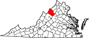 Map of Virginia highlighting Rockingham County | |
| CDPs | ||
| Unincorporated communities |
| |
| Footnotes | ‡This populated place also has portions in an adjacent county or counties | |
| ||
| Authority control |
|---|