Iron Cove Bridge
The Iron Cove Bridge is a heritage-listed road bridge that carries Victoria Road (A40) across Iron Cove, linking the Sydney suburbs of Drummoyne to Rozelle in the City of Canada Bay local government area of New South Wales, Australia.[2]
Iron Cove Bridge | |
|---|---|
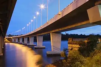
 The heritage-listed truss Iron Cover Bridge, pictured in 2006 | |
| Coordinates | 33°51′32″S 151°09′44″E |
| Carries | Victoria Road
|
| Crosses | Iron Cove |
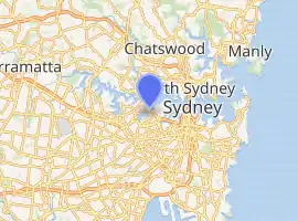
| Locale | City of Canada Bay, Sydney, New South Wales, Australia |
| Begins | Drummoyne (west) |
| Ends | Rozelle (east) |
| Other name(s) | RTA Bridge No. 65 |
| Owner | Transport for NSW |
| Characteristics | |
| Design | Pratt truss bridge |
| Material | Steel |
| Trough construction | Reinforced concrete |
| Total length | 461.26 metres (1,513 ft) |
| Width | 13.7 metres (45 ft) |
| Longest span | 52 metres (171 ft) |
| No. of spans | 11: 4 approach; 7 bridge |
| Clearance below | 12 metres (39 ft) |
| History | |
| Designer | Laurie Challis |
| Contracted lead designer | NSW Department of Main Roads |
| Fabrication by | Clyde Engineering Co. Ltd |
| Construction start | 1947 |
| Opened | July 1955 |
| Replaces | Iron Cove Bridge (1882-1955) |
| Official name | Iron Cove Bridge; RTA Bridge No. 65 |
| Type | State heritage (built) |
| Designated | 21 July 2003 |
| Reference no. | s.170 |
| Type | Road Bridge |
| Category | Transport - Land |
| Location | |
| |
| References | |
| [1] | |
Current bridges
A decision to replace the original bridge was made in 1939 just prior to the outbreak of World War II. Design work began in 1942 and construction by Hornibrook McKenzie Clarke Pty Ltd commenced in 1947. The bridge was officially opened by the Hon. J.J. Cahill, MLA, Premier and Colonial Treasurer of NSW on 30 July 1955.
Designed by Laurie Challis from the NSW Department of Main Roads, the Iron Cove Bridge is an impressive steel truss bridge. It consists of four 18-metre (59 ft) plate girder approach spans and seven 52-metre (171 ft) steel Pratt truss spans for a total length of 461.26 metres (1,513 ft). Four lanes of traffic are located within the truss spans and the overall width of the roadway is 13.7 metres (45 ft) between kerbs. The roadway consists of a 127-millimetre (5 in) reinforced concrete deck slab with an inset for tram tracks in the centre portion.[2]
The bridge has aesthetically distinctive piers and abutments which reflect the Inter-War Art Deco style. Furthermore, it was the last steel truss bridge to be constructed in New South Wales in which rivets were used for field connections prior to the introduction of high strength bolts.[2]
The bridge was built to carry four lanes of traffic, however a fifth lane was later added to the southwest side of the bridge. This extra lane ran outside of the main bridge supports, forcing traffic to remain in the lane for the length of the bridge. Until the bridge duplication completed in 2011, the default configuration was three westbound and two eastbound lanes, switching to two westbound and three eastbound lanes during the morning peak.
Bridge duplication
Iron Cove Bridge (duplication) | |
|---|---|
 | |
| Coordinates | 33°51′32″S 151°09′44″E |
| Carries | Victoria Road
|
| Characteristics | |
| Design | Box girder |
| Material | Concrete |
| History | |
| Construction start | July 2009 |
| Opened | 28 January 2011 |
In April 2009, the NSW Government approved plans to construct a second bridge over Iron Cove as part of the Inner West Busway along Victoria Road.[3]
During the proposal phase there were strong protests against the duplicate bridge being built from local residents as well as both local area councils of the City of Canada Bay (Drummoyne side) and Leichhardt (Rozelle side). Local residents within both Drummoyne and Rozelle formed the Victoria Road Community[4] and organised public demonstrations, the last of which on 29 March 2009 attracted over 3000 protest marchers.[5] Opposition to the new bridge was based on independent evaluations concluding that there would be only slight improvements to traffic congestion citybound on Victoria Road during peak hour while local congestion would worsen. Additionally, parkland on both sides of the new bridge would be reduced and independent environmental studies showed the local environment detrimentally impacted by the new bridge construction.
Work on the duplicate bridge commenced in July 2009 and the bridge was opened to traffic late on 28 January 2011.[6] The new bridge was constructed on the western side of the 1955 bridge and carries three westbound traffic lanes with one lane designated as a morning peak bus lane. There is also a 4.3-metre-wide (14 ft) grade-separated shared pedestrian footpath and cycleway on the western side of the new bridge which connects to both The Bay Run and Victoria Road. The 1955 bridge now carries three citybound traffic lanes and a 24-hour bus lane. The additional lane of the 1955 bridge outside the bridge supports was closed and is now only used for maintenance reasons.
First bridge
Iron Cove Bridge (former) | |
|---|---|
 | |
| Coordinates | 33°51′32″S 151°09′44″E |
| Characteristics | |
| Material | Wrought iron |
| Total length | 347 metres (1,137 ft 3 in) |
| Width | 7 metres (24 ft) |
| Longest span | 38 metres (126 ft) |
| No. of spans | 9 |
| Piers in water | 8 |
| History | |
| Construction start | April 1878 |
| Opened | 22 November 1882 |
| Replaced by | Iron Cove Bridge (1955–current) |
| References | |
| [7] | |
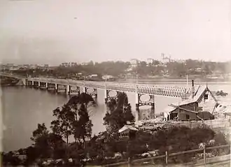
The original bridge was constructed of wrought iron lattice girders and opened in 1882 after four years of construction. The area was sparsely populated in the 1880s and the opening of the new bridge not only helped accessibility but also provided a new western route to Sydney via Balmain. The old spans were re-used by means of purchase by Gordon Duff. Because of their good resistance to corrosion, all nine of the 1882 bridge's 38.5-metre (126 ft) spans are in current use in three bridges on country roads in the Forbes area.[8] All that remains in place of the original bridge are the sandstone abutments situated on both sides of the cove approximately 20 metres (66 ft) south of the current bridge. The abutment on the Drummoyne side is listed on the local government heritage list.[9]
See also
- List of bridges in Sydney
- List of Art Deco buildings in Sydney
- The Bay Run, a popular pathway for joggers, walkers and cyclists which passes across Iron Cove Bridge
References
- "Bridge Ahoy! Iron Cove Bridge". Bridge Ahoy!. Information and Cultural Exchange. 2014. Retrieved 12 July 2015.
Bridge Ahoy! A Curated tour of the Bridges of Sydney Harbour. Created for Sydney Architecture Festival 2014 by Information and Cultural Exchange. Supported By Roads and Maritime Services
- "Iron Cove Bridge". New South Wales State Heritage Register. Office of Environment and Heritage. Retrieved 14 April 2020.
- "$100 Million Victoria Road Upgrade" (Press release). New South Wales Government. 20 November 2006.
- "Victoria Road Community Committee Inc". Archived from the original on 13 October 2009. Retrieved 26 January 2020.
- "Protesters carry bridge row to the street". The Sydney Morning Herald. AAP. 30 March 2009.
- O'rourke, Jim (30 January 2011). "Inner-west's bridge of sighs". The Sydney Morning Herald.
- "OPENING OF THE IRON COVE BRIDGE". The Sydney Morning Herald (13, 938). New South Wales, Australia. 30 November 1882. p. 13. Retrieved 4 November 2016 – via Trove, National Library of Australia.
- "Sydney Travellers' Guide: Sydney Harbour Vantage Points". 13 January 2015. Archived from the original on 13 January 2015. Retrieved 4 November 2016.CS1 maint: bot: original URL status unknown (link)
- "Iron Cove Bridge Abutment". New South Wales Heritage Database. Office of Environment and Heritage. Retrieved 25 December 2006.
Attribution
![]() This Wikipedia article contains material from Iron Cove Bridge, entry number s.170 in the New South Wales State Heritage Register published by the State of New South Wales and Office of Environment and Heritage 2020 under CC-BY 4.0 licence, accessed on 14 April 2020.
This Wikipedia article contains material from Iron Cove Bridge, entry number s.170 in the New South Wales State Heritage Register published by the State of New South Wales and Office of Environment and Heritage 2020 under CC-BY 4.0 licence, accessed on 14 April 2020.
Further reading
- Lawrence, J.; Warne, C. (1995). A Pictorial History of Balmain to Glebe. Kingsclear Books. ISBN 0-908272-40-5.
- "Iron Cove Bridge". RTA Heritage and Conservation Register. Roads and Traffic Authority, New South Wales.
- "About Us". Website. Baulderstone Hornibrook. Retrieved 1 October 2006.
External links
![]() Media related to Iron Cove Bridge at Wikimedia Commons
Media related to Iron Cove Bridge at Wikimedia Commons
- Roads and Traffic Authority, New South Wales
- Inner West Busway (RTA)
- Duplication proposal (RTA)
- Local Images at InnerWest ImageBank
- Local History Collection, Leichhardt Council
- Victoria Road Community Committee Inc