Princes Motorway
The Princes Motorway is a 55-kilometre (34 mi)[1] predominately dual carriage untolled motorway that links Sydney to Wollongong and further south through the Illawarra region to Albion Park Rail. Part of the Australian Highway 1 network, the motorway is designated with the route number M1.
Princes Motorway F6 Freeway / Southern Freeway | |
|---|---|
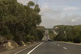 | |
Princes Motorway near Helensburgh | |
Princes Motorway | |
| Coordinates | |
| General information | |
| Type | Motorway |
| Length | 55.4 km (34 mi)[1] |
| Opened | 1963 (initial at-grade section) 1964 (as F6) |
| Route number(s) |
|
| Former route number |
|
| Major junctions | |
| North end | |
| |
| South end | |
| Location(s) | |
| Major suburbs / towns | Helensburgh, Wollongong, Figtree, Dapto |
| Highway system | |
The motorway is sometimes known by its previous signposting F6 (Freeway Route 6) and its previous name, the Southern Freeway, which applied to the sections between Waterfall and Bulli Tops as well as Gwynneville and Yallah.[2] The section between Bulli Tops and Gwynneville was known as Mount Ousley Road, and was first built as a defence route and later upgraded to dual carriageway standards. In early 2013, as part of the New South Wales alphanumeric route conversion process, the entire motorway was renamed to its current name.[3]
It is the backbone of road traffic in the Illawarra.[4] As Wollongong and Port Kembla are important industrial centres, freight traffic is heavy. Despite the current decline of the local steel industry, emergence of Wollongong as a commuter city of Sydney has kept the motorway busy.
Sections
In the north, the Princes Motorway route starts at Waterfall, taking more or less a parallel route with Princes Highway until the sprawling Bulli Tops interchange (with Appin Road (State Route 69) and Princes Highway). There it continues downhill, avoiding the steep Bulli Pass, and bypasses Wollongong CBD, through Gwynneville and continues for 20 kilometres (12 mi), bypassing the suburb of Yallah, and rejoining the Princes Highway north of Albion Park Rail near the Princes Highway junction with the Illawarra Highway. The motorway can be divided into three sections, with the two sections of the former F6 split by Mount Ousley Road in the middle.[4]
Gwynneville to Yallah section
The construction of this first section of motorway commenced in May 1959, initially as a bypass of the Wollongong City Centre.[4] A small section of this route, between Princes Highway and Foley Street, opened in December that year [4] The full first section opened to traffic in July 1963, though as a two-lane road with at-grade intersections.[4] The connection to Mount Ousley Road was made in March 1964, signalling the beginnings of the F6.[4] Duplication of the route to West Wollongong was completed in 1965.[4] The freeway continued making its way southward, with extensions to Masters Road opening in 1967, to Northcliffe Drive in 1973 (albeit as a single carriageway, with duplication finished in 1975), to Kanahooka Road in 1978 (with duplication concluding in 1979), Fowlers Road in 1981 (with duplication concluding in 1983), and to its current terminus at Yallah in 1986 (with duplication concluding in 1987).[4] The intersection with the Northern Distributor at Gwynneville remained an at-grade intersection before a new intersection was built and entered service in December 1998.[4]
Waterfall to Bulli Tops section
Construction of the section between Waterfall and Bulli Tops commenced in July 1970.[4][5] At 22.9km, it was then the longest section of freeway to completed at one time, at a cost of $30.5 million.[4] Financed by State Government bonds, from its opening on 24 July 1975, this section of freeway initially incurred a toll.[5][6] This part of the freeway did not feature the Helensburgh Interchange (which subsequently opened in February 2000). The toll operated for 20 years, which was 10 years short of its intended operating length. The main reason for this was local residents complaining that the F3 Freeway had its toll dropped in 1988, which was at the time intended to be dropped as its loans had been fully paid off unlike those of the F6.
After much pressure the toll for the F6 freeway was removed on 30 July 1995 as the loans had been repaid.[7] Remnants of the tollbooths are still able to be seen at the old toll plaza at Waterfall. One of the lanes and very faint markings are still intact. Heading southbound one set of warning lights to slow down for the toll plaza are also still intact minus signage. Also constructed to complement the tollway were the dual carriageways from Waterfall north to Loftus, and the Sutherland Bypass, which opened to traffic on 16 September 1975.[4]
Mount Ousley Road section
The section between Bulli Tops and Gwynneville was previously known as Mount Ousley Road,[8] and is still often referred to as such.[9] It was built in 1942 as a defence route and was later upgraded to dual carriageway to help facilitate traffic as it now connects the two sections of the F6.[8] It is sometimes not considered part of the freeway proper,[4] as it is not fully built to freeway standards, containing left-in/left-out intersections and an at-grade intersection, though most major intersections are fully controlled access.[8] This at-grade intersection, located at the base of Mount Ousley, is currently under investigation for upgrading to a full controlled-access intersection.[10]
In November 2015, it was announced that the section between Bulli Tops and Picton Road would have a third lane added in each direction.[11]
Exits and interchanges
| LGA | Location | km | mi | Destinations | Notes |
|---|---|---|---|---|---|
| Sutherland | Waterfall | 0 | 0.0 | Northern terminus; continues north as the Princes Highway | |
| 0 | 0.0 | Princes Highway – Woronora Dam, Helensburgh | Northbound entrance and southbound exit only | ||
| Wollongong | Helensburgh | 6.49 | 4.03 | Exit to Lawrence Hargrave Drive – Helensburgh, Stanwell Tops, Stanwell Park, Otford | Southbound exit only |
| 7.1 | 4.4 | Entrance via Lawrence Hargrave Drive – Helensburgh, Stanwell Tops, Stanwell Park, Otford | Southbound entrance only | ||
| 7.4 | 4.6 | Princes Highway – Helensburgh, Stanwell Tops, Stanwell Park, Otford | Northbound entrance only | ||
| 7.8 | 4.8 | Princes Highway – Helensburgh, Stanwell Tops, Stanwell Park, Otford | Northbound exit only | ||
| Thirroul | 18.5 | 11.5 | Princes Highway – Sublime Point Lookout and Maddens Plains, Bulli, Corrimal | Southbound exit only | |
| 19.3 | 12.0 | Princes Highway – Sublime Point Lookout, Maddens Plains, Bulli and Corrimal | Southbound entrance only | ||
| 21 | 13 | Southbound exit and northbound entrance only | |||
| Balgownie | 30.1 | 18.7 | Northbound entrance only | ||
| 30.4 | 18.9 | Southbound and northbound exits only | |||
| 30.9 | 19.2 | Southbound entrance only | |||
| 31.3 | 19.4 | Clive Bissell Drive - Mount Keira | Northbound exit and entrance only | ||
| 34.2 | 21.3 | New Mount Pleasant Road - Balgownie, Fairy Meadow | Southbound exit only | ||
| Mount Ousley | 35.7 | 22.2 | Mount Ousley Road - Mount Ousley to Princes Highway and | Southbound exit only | |
| 35.8 | 22.2 | Mount Ousley Road - Mount Ousley from Princes Highway and | Northbound and southbound entrances only | ||
| Keiraville | 36.0 | 22.4 | Northfields Avenue - University of Wollongong, Keiraville, Gwynneville | Northbound entrance and northbound exit to both Northfields Avenue and Irvine Street only | |
| 36.2 | 22.5 | University Avenue - University of Wollongong, Keiraville, Gwynneville | Southbound exit and entrance only | ||
| Gwynneville | 36.5 | 22.7 | Northbound entrance and southbound entrance only | ||
| 36.8 | 22.9 | To | Southbound exit only | ||
| Mangerton | 38.7 | 24.0 | Princes Highway - Wollongong, Figtree | Northbound entrance and exit; southbound exit and entrance | |
| Figtree | 39.9 | 24.8 | Masters Drive - Spring Hill, Port Kembla, Wollongong | Northbound entrance and southbound exit only | |
| 40.6 | 25.2 | Masters Drive - Spring Hill, Port Kembla, Wollongong | Southbound entrance only | ||
| Unanderra | 42 | 26 | Five Islands Road - Unanderra, Port Kembla | Northbound entrance and exit; and southbound exit and entrance | |
| Berkeley | 45.1 | 28.0 | Northcliffe Drive - Kembla Grange, Warrawong, Port Kembla | Northbound entrance and exit; southbound exit and entrance | |
| Kanahooka | 47.8 | 29.7 | Kanahooka Road - Dapto, Kanahooka, Koonawarra | Northbound entrance and southbound exit only | |
| Dapto | 49.5 | 30.8 | Fowlers Road - Dapto, Koonawarra | Northbound entrance and southbound exit only | |
| Shellharbour | Yallah | 52.7 | 32.7 | Exit to Princes Highway – Yallah, Dapto | Northbound exit only |
| 53.3 | 33.1 | Princes Highway – Yallah, Dapto | Southbound entrance only | ||
| Haywards Bay | 54.3 | 33.7 | Yalla Road from Princes Highway; to Haywards Bay Drive – Haywards Bay | Northbound entrance and southbound exit only | |
| 54.7 | 34.0 | To Yalla Road; from Haywards Bay Drive – Haywards Bay | Northbound exit and southbound entrance only | ||
| Albion Park Rail | 55.4 | 34.4 | Southern terminus; continues south as the Princes Highway | ||
| 55.4 | 34.4 | Westbound as the | |||
| 1.000 mi = 1.609 km; 1.000 km = 0.621 mi | |||||
Proposed extensions
Northern extension
_01.jpg.webp)
The County of Cumberland planning scheme of 1948 outlined an F6 extension from the current-day end-point at Waterfall.[12] As such, an F6 corridor was set aside that passes through the Royal National Park from Waterfall to Campbell Road in St Peters. The land reservation tract currently passes through the suburbs of Loftus, Kirrawee, Gymea, Miranda, Taren Point, Sandringham, Sans Souci, Ramsgate, Monterey, Kogarah, Brighton-Le-Sands, Rockdale, Banksia, Arncliffe, Kyeemagh and Tempe.[13]
Of the proposed extension, only the six-lane Captain Cook Bridge and a short connecting section of Taren Point Road to the south have been built. Establishment of the bridge section of the F6 extension began in 1962, expedited to replace the ferry service that had operated from Taren Point to Sans Souci since 1916. Captain Cook Bridge was opened in May 1965.[14]
In the original plan, the F6 would connect to the Western Distributor.[15] Then, in August 1977, premier Neville Wran cancelled the inner section of the F6 link, which at the time had an estimated construction cost of $96 million.[14] At the same time, Wran announced that the inner section reservation would be sold off and the proposed extension would instead terminate at St Peters, a medium density industrial suburb.[14][16][17]
Prior to the 2007 federal election, the Liberal-Nationals (Coalition) government promised to allocate $20 million towards planning for the F6 extension.[18] Although the Coalition lost the 2007 election,[19] the funding was once again promised at the subsequent 2010 federal election. This funding would ensure the project is "shovel ready" when funding becomes available.[20]
In the mid 2010s, the F6 extension project was revived under the Liberal-National coalition state government. This project has since been renamed M6 Motorway.
Southern extension
At the southern end, the Princes Motorway will be extended to Oak Flats along the 9.8 km Albion Park Rail Bypass, which is undergoing construction.[21] The bypass is expected to be completed in mid-2021, one year ahead of schedule.[22][23] The bypass will also complete the 'missing link' for a high standard road between Sydney and Bomaderry.[21]
The bypass is being built on a reserved corridor which was identified by Roads and Traffic Authority in a study in the mid 1990s. In 2013, the Roads and Maritime Services confirmed the reserved corridor to be suitable for the bypass.[21]
References
- "Princes Highway & A1 & M1 & Princes Motorway, New South Wales to 3-5 Princes Highway, Albion Park Rail NSW 2527". Google Maps. Google. 2016. Retrieved 11 October 2016.
- F6 Southern Freeway, Ozroads: the Australian Roads Website. Retrieved 24 August 2008.
- "Information for Southern NSW & ACT". Alpha-numeric route numbers. Roads and Maritime Services. 20 May 2013. Retrieved 13 June 2013.
- "F6 Southern Freeway : History and Development". OZRoads: The Australian Roads Website. Retrieved 28 November 2018.
- Tollwork to link centres Truck & Bus Transportation July 1970 page 181
- Lewis Opens Super Road Illawarra Mercury 25 July 1975
- State Government abolishes F6 charge Daily Telegraph Mirror 17 May 1995 page 5
- "NATIONAL ROUTE 1 - Mount Ousley Road section". OZRoads - The Australian Roads Website. Retrieved 28 November 2018.
- Thompson, Angela. "Woman hurt after car wedged under truck and dragged down Mount Ousley". Illawarra Mercury. Retrieved 28 November 2018.
- "Mount Ousley interchange". NSW Government. Retrieved 28 November 2018.
- Humphries, Glen (2 November 2015). "Extra lanes for motorway between Picton Road and Bulli Tops". Illawarra Mercury. Archived from the original on 3 November 2015.
- "10 reasons for not building an F6 Motorway" (PDF). Sutherland Shire Environment Centre. 2005. Retrieved 30 August 2010.
- "F6 Corridor Public Transport Use Assessment" (PDF). Roads and Traffic Authority. September 2004. Archived from the original (PDF) on 4 April 2012. Retrieved 30 August 2010.
- "F6 Southern Freeway : History and Development". Ozroads. Retrieved 30 August 2010.
- "Western Distributor - Construction Information". Retrieved 11 May 2011.
- Baker, Jordan (27 February 2007). "Shire will become car park unless F6 is built: NRMA". The Sydney Morning Herald. Retrieved 30 August 2010.
- Baker, Jordan (12 February 2007). "F6 extension – the great dividing road". The Sydney Morning Herald. Retrieved 30 August 2010.
- "$20 million worth of progress on F6". NRMA. 5 November 2007. Archived from the original on 28 November 2010. Retrieved 30 August 2010.
- "Kevin Rudd claims victory in federal election". The Sydney Morning Herald. 24 November 2007. Retrieved 30 August 2010.
- Kelly, Craig; Morrison, Scott (2 August 2010). "Morrison/Kelly Announce $20 Million to Get F6 Extension Tunnel Shovel Ready". Liberal Party of Australia. Archived from the original on 26 August 2010. Retrieved 30 August 2010.
- "Albion Park Rail bypass - Princes Highway upgrade". Roads and Maritime Services. Retrieved 30 October 2019.
- "Early opening for Albion Park Rail Bypass". Transport for NSW - Roads and Maritime. 16 November 2020. Retrieved 19 November 2020.
- "Albion Park Rail bypass - Project Update June 2019" (PDF). Roads and Maritime Services. June 2019. Archived from the original (PDF) on 23 June 2019. Retrieved 23 June 2019.
| Wikimedia Commons has media related to Princes Motorway. |
Road infrastructure in regional New South Wales | ||
|---|---|---|
| Motorways | ||
| Major highways | ||
| Minor highways |
| |
| Other roads |
| |
| Road bridges (disused/former) |
| |
| Vehicular ferries | ||
| Tunnels | ||