Israeli expropriation of Palestinian springs in the West Bank
The Israeli expropriation of Palestinian springs in the West Bank is the expropriation of springs in the Israeli-occupied West Bank by Israel, the Israeli water company Mekorot, and by Israeli settlers. The springs and wells, to which Palestinians have a human right in international law, are appropriated exclusively for use by Israelis and visiting tourists.[1][2]
Nomenclature
The topographical feature of a spring in semitic languages, and specifically in both Arabic: (عين) and Hebrew: (ןיִעַ), variously transliterated as ayn, en, ein, also means 'eye' (socket),[3] a spring in the arid terrain of the Middle East being naturally understood to be a kind of 'eye of the landscape'.[4] Given their importance, many toponyms in Palestine incorporate the word in terms for towns and localities.[4][lower-alpha 1]
Background
The groundwater resources on which Israel depends draw on 3 aquifers, only one of which is in Israel and of the recharge area of the water tables only 5% lies in Israel. The West Bank's resources are either surface run-off channelled in streams and rivers or groundwater and the population down to the 1980s had not been allowed to access more than 14-18% of the total water available.[5] Israel's perceived and programmed water security depends on minimizing Palestinian use of the aquifers in their own territory of the West Bank.[6]
Historically, spring water had always been managed by villages adjacent to springs, which lay within their boundaries. The earlier British mandatory authority had difficulties formulating a water law given the diversity of regional practices, and all efforts by them to do so failed. In that period, however, the Zionist leadership often argued its case for increasing Jewish immigration by asserting that efficient modern techniques of water management would ensure a limitless capacity for absorbing these immigrants: water, they argued, was abundant, all that was lacking was expertise in developing modern infrastructure. The future Israeli water company Mekorot was set up in 1937 to this end. However, with the establishment of the state of Israel, the range estimates for available water resources in Palestine were scaled back significantly, and the imagined abundance was replaced by a recognition of water scarcity.[7] Israel centralized and nationalized its water resources in 1959.
Until 1950, when Jordan claimed the West Bank by annexation - a move not recognized by the international community - most Palestinian villages drew the majority of their water from springs and by collecting rainwater.[8] In the wake of the 1948 Palestine war, the inhabitants of the historic core of Jerusalem and its eastern neighbourhoods had lost access to the Ras al-'Ayn and 'Arrub springs, and, until pumping station facilities were repaired, the severities of rationing were eased by drawing on the springs in Silwan and Sur Bahir.[lower-alpha 2]
The springs had traditionally been managed by a communal property regime.[8] Irrigated agriculture in villages mainly depended on these springs.[6] Improved technology allowed wells to be dug in the ensuing decade. Villagers pooled funds in order to create 'well companies' in order to secure finance for drilling. Jordan set up a Jerusalem Water Utility in the mid 1960s, but it serviced only the three cities of Bethlehem, Jerusalem and Ramallah. This project stopped when Israel conquered and occupied the West Bank in 1967.[lower-alpha 3]
Israel thereafter did not extend its water laws to the captured territories, which were run by a military administration. That authority quickly issued Military Order no. 92 investing a military officer with all powers regarding the management of water resources in what became the Palestinian territories. Military Order no. 158 later stipulated that wells could be drilled only after obtaining a military permit, and, over the ensuing 23 years, only twenty three such permits were issued.[8][lower-alpha 4] Springs waters, however, were rarely touched, and the existing regime allowing villages to continue with their property management regarding the use of such resources.[8]
The minimum mean for daily per capita water consumption set by WHO is 100 litres per day: the average in the West Bank is 66 litres.[9] The state-owned Israeli company Mekorot taps springs and drills wells in the West Bank and furnishes settlements with water for all purposes, industrial, agricultural and domestic. It also sells some to Palestinian water utilities, according to schedules Israeli authorities determine to fix the allowable amount. For many villagers whose access to local sources is severely restricted, the end result is that they must often purchase trucked-in water priced much higher than that supplied to settlements,[lower-alpha 5] and in the poorest communities the monthly outlay for imported water can rise to half of a family income.[1]
Settlement usurpations of springs after 1967
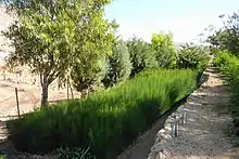
At least 300 springs exist in the West Bank.[10] In the process of establishing Israeli settlements, many of these springs were targeted by the settlers, and the struggle to wrest possession of the areas of the landscape that feature them was, and remains, a notable source of conflict between local Palestinians and the immigrant Jewish communities.[11][12] In a survey conducted in 2011, the United Nation's Office for the Coordination of Humanitarian Affairs occupied Palestinian territory identified 56 springs that had either been taken over by settlers (30), or were the object of targeting for eventual inclusion into the settlement areas (26). 93% of these were in Area C, on parcels of land that, according to the records of the Israeli Civil Administration, in large part (84%) are registered as private Palestinian property.[13][lower-alpha 6]
One technique relies on the practice by the IDF of declaring large areas of West Bank land military fire zones where (Palestinian) civilians may not enter. The six settler Regional Councils in the West Bank are supposed to operate under a military ordinance regulating their activities within defined municipal boundaries, but, according to Haaretz's Yotam Berger the civil/military administration turns a blind eye to the phenomenon or even encourages the settler groups to develop infrastructure on lands beyond their municipal jurisdiction that are otherwise closed military zones or private Palestinian property.[14]
Many of the sequestered springs are designated as Israeli parks, in a broader process of what has been called 'colonial ecologism',[15] or 'apartheid springs.'[11]
Springs seized for settlements (by 2011)
The following is a list of 30 springs that had fallen under the complete control of Israeli settlements by 2011.[16]
| Spring name | Palestinian village | Israeli settlement/outpost | hebraicized name |
|---|---|---|---|
| Ein el-Azkut | Bardala[lower-alpha 7] | Jordan Valley Regional Council | Ein Sukot |
| Ein Um Al Jarah | Awarta | Itamar | Ein Nerya |
| Ein El Mukheimer | Al-Lubban ash-Sharqiya | Eli | N/A |
| Ein El Michna | Burin | Har Brakha | Ein Yosef/Ein Amasa |
| Ein El Jneinah | Burin | Yitzhar | Ein Magnunim |
| Ein El Sha'ara | Burin | Yitzhar | N/A |
| Ein El Kbireh | Deir al-Hatab | Elon Moreh | Ein Kfir |
| Ein El Ariq | Qaryut | Eli | Ein Hagvura |
| Ein Ad Dweer | Al Jib | Giv'at Ze'ev | Ein Dvir |
| Al Uyoon | An-Nabi Samwil | Samuel National Park | N/A |
| Ein El-Balad | An-Nabi Samwil | Samuel National Park | Ein Tiltan |
| Ein Um Ntukh | Al-Mazra'a al-Qibliya | Nahliel Nerya | N/A |
| Ein Al Marj | Bayt Nuba | Canada Park | Beit Hakshatot |
| Ein Khaled | An Nabi Salih | Halamish | |
| Ein Al Qaws | An Nabi Salih | Halamish | Ein Meir |
| Ein Husein | Ein Yabrud | Beit El | N/A |
| Ein Addallah | Ein Yabrud | Beit El | N/A |
| Ein Issa | Al Bireh | Beit El | N/A |
| Ein El Masraj | Al-Janiya | Talmon | Ein Talmon |
| Ein El Mallah | Al-Janiya | Talmon | N/A |
| Ein El Thahra | Al Bireh | Beit El | N/A |
| Ein Ash Shunnar | Beitilu | Nahliel | N/A |
| Ein El Butmeh | Ras Karkar | Talmon Zait Raanan | N/A |
| Ein al-Sajma [lower-alpha 8] | Khallet al Baluta | Bat Ayin | Ein Yitzhak |
| Ein Abu Zaid | Nahalin | Rosh Tzurim | Ein Tzurim |
| Ein El Abhara | Jab'a | Bat Ayin | Ein Livne |
| Ein Ras al 'Idd | al-Khader | Efrat | Ein Ha'ama |
| Ein Hubileh | Khirbet Safa | Bat Ayin | Ein Hunile |
| Ein Abu Kleibeh | Nahalin | Havot Eyalin | Ein Misla |
| Uyoon al Beid | Yatta | Avigayil | Beseter Ha-har |
Springs at risk by 2011
The following is a list of Palestinian springs that were considered by United Nations investigators to be at risk of a settler takeover in 2011.[17]
2012-2020
The West Bank Ein Hanya spring, which from Ottoman times down to the end of the British Mandate was recognized as the property of al-Walaja,[18] now lies within the municipal boundaries of Jerusalem, and the inhabitants of the village are cut off from it by Israeli West Bank barrier.[19] It was frequented by Israelis and Palestinians. Problems started when it was designated as a tourist attraction and enclosed within what Israel calls one of its national parks, the Emek Refaim Park. The opening was delayed for two years as police, together with the Jerusalem Municipality and the Nature and Parks Authority,[19] insisted that Palestinians be refused entry, and that the government shift the Ein Yael checkpoint south in order to block Palestinian access, an operation that would cost $3.4 million. It was opened to Jews for three days during the Sukkot festival, which coincided with the Palestinian olive picking season[19] but Palestinians, even those wishing to harvest the fruits of their olive groves, are denied access,[20][19][lower-alpha 9] a ban extending also to the inhabitants of al-Walaja itself, who own 297 acres (120 ha) of the area.[19]
| Spring name | Palestinian village | Israeli settlement/outpost | hebraicized name |
|---|---|---|---|
| ? | ? | Mateh Binyamin Regional Council | Ein Oz[14] |
| Ein al-Major | Ein Qiniya | Dolev | Ein Mazor[21] |
Incidents
Three members of the Shnerb family, from Lod in Israel, were hiking in the West Bank when a bomb planted at Ein Bubin was made to explode, killing the girl, and injuring her brother and father b.[22] The murder took place near to the Palestinian village of Deir Ibzi,[23] whose lower lands near the spring area are abandoned because they are denied access save for two or three days a year.[11] Israeli settlements are considered illegal under international law, something Israel disputes, and over 600,000 Jews have come to live in roughly 140 of such settlements since Israel occupied the area militarily in 1967.[23] Springs in particular are flashpoints in the conflict between Israelis who come to settle in the West Bank and the local Palestinian villagers,[lower-alpha 10] with, according to Dror Ektes, over 60 springs so far seized in the past 10 years, and thereupon reserved for Jewish use only.[lower-alpha 11]
According to Amira Hass, the site is one of nine in an area where, over three decades, the settlements of Dolev and Nahliel, and illegal Israeli outposts between them, have seized control over some 3,700 acres of Palestinian land. Palestinians in six adjacent villages, Kobar, Ras Karkar, Al-Janiya, Deir 'Ammar, Al-Mazra'a al-Qibliya and Beitillu – all cut off from each other through prohibitions on road use - have been denied access to their groves, springs and grazing land by a variety of settler and army measures - vandalism of trees, military orders, and assaults.
Five of the villages' nine springs have, she claims, been appropriated from Palestinians,[12] who formerly used them for swimming, picnicking and for agricultural purposes. The seizures adapt them as recreational sites exclusively for settlers and touring Israeli Jews. The loss of land and water resources has, she continues, dealt an economic blow to inhabitants of the six villages, causing many families to rely now on aid. With regard to the incident specifically Hass concluded that, ‘those who prepared the bomb certainly know that this is Israel's strategy in the West Bank. Individual settlements are turned into broad blocs, for Jews only, and are boasting of abundance, serenity, commercial centers, vineyards, orchards, hiking trails and Judaized natural springs.'[12]
See also
Notes
- As opposed to natural springs, a dug well, in Arabic بئر (bir) and in Hebrew ראֵבְּ (be'er) as in Beersheba, the 'well of seven'. (Freund 2009, p. 319)
- The source fails to clarify why the Arrub springs, which remained under Jordanian control, could no longer be exploited to serve the city. Traditionally Jerusalem could also rely on a well at bir Arrub further down the valley. (Dumper 1997, pp. 131,135)
- On the eve of the war, consumption of water in the Jewish sector of West Jerusalem was 36,000 cubic metres as compared to 2,000 cubic metres for the inhabitants of the Jordanian-controlled sector to the east who, in per capita terms, had access to 21% of the water available west of the Green Line. (Dumper 1997, p. 135)
- Lowi however wrote in 1995: 'No Palestinian individual or villager has received permission to drill a new well for agricultural purposes since July 1967, nor repair one that is close to an Israeli well. Sinking wells on the mountain ridge, the location of the Yarkon-Taninim Aquifer, is strictly forbidden. Occasionally, permission is granted for the drilling of wells destined for domestic use.' (Lowi 1995, p. 187)
- $6-10US per cubic metre
- 'Analysis done by the anti-occupation Kerem Navot organization shows that since the Oslo accords were signed, these councils have been operating in roughly 550,000 acres (220,000 ha)s lying in the West Bank's Area C, comprising almost 40 percent of the entire area of the West Bank. However, more than 225,000 acres (91,000 ha) of these are closed military areas, while another 70,000 acres (28,000 ha) are privately-owned Palestinian lands.' (Berger 2019)
- A farmer in the nearby village of Ein al-Beida is reported as having seen over the last 2 and a half decades 'the local spring gradually dry up after the Israeli company Mekorot drilled two wells near the neighbouring Palestinian community of Bardala, to serve Mehola, an Israeli settlement. The amount of water the Israeli authorities allocate to the village has been decreasing over the years, he says, and has been fully cut off on numerous occasions. Despite an agreement to compensate the Palestinian villages of Bardala and Ein al-Beida, since the mid-1970s, Israel has significantly reduced the amount of water available to both communities.' (Lein 2000, pp. 30–31, Amnesty International 2017)
- This spring is on private Palestinian land. (Berger 2019)
- "'When we arrived here there was an old man sitting under his fig tree, and shepherds would come to water their flocks – the place was enchanted. It was like a focal point of activities in the area. Our intention was to tidy it up a bit and then leave, as if we'd never been here', recalls landscape architect Iris Tal, who was charged with upgrading the area surrounding Ein Hanya, the second-largest spring in the Judean Hills... After 3,000 years in which the spring was open to and frequented by local Jews, Christians and Muslims, the Jerusalem Municipality is planning to set up a roadblock nearby which will prevent thousands of residents from the adjacent Palestinian villages of al-Walaja and Battir and environs from reaching the site." (Riba 2018)
- ' Springs on the West Bank have become flash points between Palestinians who bathe or water their flocks in them and Jewish settlers who have increasingly sought to prevent them from doing so. A 2012 United Nations report identified 30 springs that had been completely “taken over” by settlers and another 26, including Ein Bubin, that were “at risk” of takeover, whether by frequent tourism or by the presence of armed patrols seen as intimidating to Palestinians.'[24]
- 'According to Dror Etkes, the founder of Kerem Navot, an organization that studies Israeli land policy in the West Bank, there are today more than 60 springs in the central West Bank that settlers coveted and seized as part of a project of plunder that began 10 years ago. The landscaping and renovation work at about half of them has been completed, the dispossession made absolute, the Palestinians blocked from even approaching the springs and their lands. Other springs targeted by the settlers are in various stages of takeover.[11]
Citations
- Amnesty International 2017.
- Amnesty International 2009.
- Sharon 2004, p. 70.
- Stanley 1856, p. 500.
- Lowi 1995, pp. 183,185.
- Lowi 1995, p. 185.
- Trotter 2013, p. 147.
- Trotter 2013, p. 148.
- Daghara, Al-Khatib & Al-Jabari 2019, p. 1.
- Daghara, Al-Khatib & Al-Jabari 2019, p. 2.
- Levy & Levac 2019.
- Hass 2019.
- OCHA 2012, p. 1.
- Berger 2019.
- Gorney 2016, p. 340.
- OCHA 2012, p. 24.
- OCHA 2012, p. 25.
- Riba 2018.
- Tatarsky 2019.
- Hasson 2019.
- Forat 2020.
- Sokol 2019.
- BBC 2019.
- Halbfinger 2019.
Sources
- Amnesty International (2009). "The Occupation of Water" (PDF). Amnesty International.
- Amnesty International (29 November 2017). "Troubled Water– Palestinians denied fair access to water". Amnesty International.
- "Israeli teenage girl killed in West Bank bomb attack". BBC News. 23 August 2019.CS1 maint: ref=harv (link)
- Berger, Yotam (31 May 2019). "Israeli Settlers 'Upgrade' West Bank Springs to Usurp Palestinian Land". Haaretz.
- Daghara, Azza; Al-Khatib, Issam A.; Al-Jabari, Maher (23 June 2019). "Quality of Drinking Water from Springs in Palestine: West Bank as a Case Study" (PDF). Journal of Environmental and Public Health. 2019: 1–7. doi:10.1155/2019/8631732. ISBN 978-0-521-55836-5. PMC 6612393. PMID 31341486.
- Dumper, Michael (1997). The Politics of Jerusalem Since 1967. Columbia University Press. ISBN 978-0-585-38871-7.
- Forat, Umm (31 January 2020). "I Went for a Run and Saw Settlers Took Over a Spring Near a Palestinian Village". Haaretz.
- Freund, Richard A. (2009). Digging Through the Bible: Modern Archaeology and the Ancient Bible. Rowman & Littlefield. ISBN 978-0-742-54645-5.
- Gorney, Edna (2016). "Roots of Identity, Canopy of Collision: Re-Visioning Trees as an Evolving National Symbol Within the Israeli -Palestinian Conflict". In de Melo, Cristina Joanaz; Vaz, Estelita; Costa Pinto, Lígia M. (eds.). Environmental History in the Making: Volume II: Acting. Springer. pp. 327–343. ISBN 978-3-319-41139-2.
- Halbfinger, David M. (23 August 2019). "Bomb Kills Israeli Girl, 17, at a West Bank Oasis". New York Times.CS1 maint: ref=harv (link)
- Hass, Amira (26 August 2019). "The Tragic Hike That Has Nothing to Do With the Landscape and Land". Haaretz.
- Hasson, Nir (15 October 2019). "Jerusalem Reopens Natural Spring, but Not to Palestinians". Haaretz.
- "How Dispossession Happens: The Humanitarian Impact of the Takeover of Palestinian Water Springs by Israeli Settlers" (PDF). Office for the Coordination of Humanitarian Affairs occupied Palestinian territory. March 2012.
- Lein, Yehezkel (July 2000). "Thirsty for a Solution: The Water Crisis in the Occupied Territories and its Resolution in the Final-Status Agreement". B'Tselem.
- Levy, Gideon; Levac, Alex (30 August 2019). "'This Place Is Only for Jews': The West Bank's Apartheid Springs". Haaretz.
- Lowi, Miriam R. (1995) [First published 1993]. Water and Power: The Politics of a Scarce Resource in the Jordan River Basin. Cambridge University Press. ISBN 978-0-521-55836-5.
- Pearce, Fred (2018). When the Rivers Run Dry: The Global Water Crisis and How to Solve It. Portobello Books. ISBN 978-1-846-27649-1.
- Riba, Naama (16 March 2018). "The Ein Hanya Spring: A Charming, Spruced-up Jerusalem Spot Free of Palestinians". Haaretz.
- Rinat, Zafrir (20 March 2012). "Report: Jewish settlers now control dozens of West Bank springs". Haaretz.
- Rinat, Zafrir (5 April 2012). "Springwater flows in the West Bank, but who controls it?". Haaretz.
- Sharon, Moshe (2004). Corpus Inscriptionum Arabicarum Palaestinae (CIAP): D-F. Volume 3. BRILL. ISBN 978-9-004-13197-2.
- Stanley, Arthur Penrhyn (1856). Sinai and Palestine: In Connection with Their History. Volume 1. London: J. Murray.
- Tatarsky, Aviv (22 October 2019). "How one Palestinian spring became a leisure spot for Israelis". +972 Magazine.
- Trotter, Julie (2013). "Water". In Peters, Joel; Newman, David (eds.). Routledge Handbook on the Israeli-Palestinian Conflict. Routledge. pp. 145–153. ISBN 978-1-136-16069-1.