Josh Morgerman
Joshua Morgerman is an American businessman, storm chaser, and TV personality best known for his multitude of tropical cyclone chases. Born in 1970, he developed an interest in meteorology at an early age. After graduating from Harvard University in 1992, he co-founded the digital advertising company Symblaze in 1999. His storm chasing career began in earnest in 2005 with Hurricane Wilma in Florida.
Josh Morgerman | |
|---|---|
| Born | 1970 (age 50–51) New York |
| Nationality | American |
| Education | Harvard University |
| Occupation | iCyclone, co-founder of Symblaze |
| Known for | Record successful intercepts of tropical cyclones |
| Website | http://www.icyclone.com |
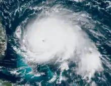
With no formal education in meteorology, all his experience comes from the chases. In all of the years he has been chasing, Morgerman has intercepted 59 tropical cyclones including Typhoon Haiyan in 2013 and Hurricane Dorian in 2019, among the worst storms on record in the Philippines and the Bahamas respectively. He has successfully entered the eye of 38 hurricane-force tropical cyclones, with the strongest being Hurricane Dorian.
Early life
Josh Morgerman was born in 1970 and grew up in Huntington, New York—part of suburban New York City. Living on Long Island, he developed an interest in meteorology at an early age; his mother attributes part of this interest to him seeing The Wizard of Oz when Morgerman was four. In August 1976, Hurricane Belle struck Long Island as a Category 1 hurricane, causing significant damage in his hometown.
At his father's insistence, Morgerman pursued a liberal arts degree at Harvard University rather than focusing on meteorology. In 1991, while attending Harvard, Morgerman went on his first hurricane chase: Hurricane Bob in Rhode Island.[1]
In 1999, Morgerman co-founded the digital advertising company Symblaze alongside his friend Michael Horton.[2] By 2004, he was living in Prague, Czech Republic, to work with Eastern European clientele.[1]
Personal life
Morgerman has no spouse nor kids, wishing to remain unburdened by family responsibilities to pursue cyclone chases.[1] In his spare time, Morgerman often studies historic tropical cyclones.[3]
iCyclone
Since 1991, Morgerman has been chasing tropical cyclones. His goal is to "core punch" the storms and record atmospheric pressure and document the experience.[1] With no formal education in meteorology, Morgerman's cyclone chasing is a passion project. All of his experience is in the field, though he advertises himself as an "adrenaline junkie". In an interview with The Washington Post in 2012, he stated this to be the primary motivator for chasing.[3]
He often relies on his instincts backed up by years of chasing cyclones. Morgerman leads the iCyclone chase team. Members include his "right-hand guy" Scott Brownfield who coordinates logistics or assists on chases, meteorologists Adam Moyer Jorge González who provide forecasting information, and Cory Van Pelt who serves as the iCyclone technician.[3] In 2013, iCyclone expanded their chase region to East Asia, teaming up with fellow chasers James Reynolds and Mark Thomas. They ultimately intercepted four typhoons in one month including Typhoon Haiyan which devastated the Philippines.[4] Since 2014, his chasing has been funded by multiple media agencies including CBS, the Weather Channel, and WeatherNation.[1] Morgerman conducted his first Australian chase in 2017, intercepting Cyclone Debbie in Queensland.[5]
Data collection and usage
Morgerman collects atmospheric pressure with multiple Kestrel 4500s. The data he has collected has been utilized by the National Hurricane Center (NHC) in multiple instances to refine landfall intensities. 2011's Hurricane Rina's landfall in the Yucatán Peninsula was adjusted in light of his observations.[3] In conjunction with satellite intensity estimates, his measurement of 975 mbar (28.8 inHg) within the eye of Hurricane Ernesto in 2012 was utilized to upgrade the hurricane's landfall intensity to Category 2.[6]
In 2014, Morgerman's measurement of 943.1 mbar (27.85 inHg) within Hurricane Odile resulted in the landfall pressure being adjusted to 941 mbar (27.8 inHg) from the operational estimate of 930 mbar (27 inHg).[7][8] His observation of 937.8 mbar (27.69 inHg) in 2015's Hurricane Patricia, in conjunction with two nearby automated measurements, assisted in more accurately analyzing the hurricane's strength at landfall. Meteorologists at the NHC concluded an approximate minimum pressure of 932 mbar (27.5 inHg), yielding estimated winds of 150 mph (240 km/h); this made Patricia the strongest Pacific hurricane on record to strike Mexico.[9]
Morgerman provided the only observed over-land pressure with Hurricane Willa's Mexican landfall in 2018. He observed a value of 968 mbar (28.6 inHg), corroborating the NHC's landfall intensity of 115 mph (185 km/h).[10]
In 2016, Morgerman collaborated with meteorologist Andrew Hagen and Mexican researchers Erik Sereno Trabaldo and Jorge Abelardo González to reanalyze the 1959 Mexico hurricane, then considered to be the strongest landfalling hurricane on the Pacific coast of Mexico. Their analysis determined the storm to have been significantly weaker than originally estimated and resulted in its downgrade from a Category 5 to a Category 4. These revisions were later incorporated into the NHC's Hurricane Database.[11] In 2017, Morgerman co-authored an academic paper published by the American Meteorological Society on the intensity of 2015's Hurricane Patricia. He provided in-situ data describing the structure of the storm and allowing for a more thorough analysis of its landfall.[12]
Tropical cyclone chases
As of October 2020, he has chased 59 cyclones across Australia, East Asia, and North America. Of his successful core penetrations, five were Category 5 and eight were Category 4.
| Year | Date | Storm | Chase location | Landfall intensity (SSHWS) | Recorded pressure | Relative position | Team | Ref. |
|---|---|---|---|---|---|---|---|---|
| 1976 | August 9–10 | Hurricane Belle | Huntington, New York | Category 1 hurricane | N/A | Inside eye | N/A | [13] |
| 1985 | September 27 | Hurricane Gloria | Huntington, New York | Category 1 hurricane | 965 mbar (28.5 inHg) | Inside eye | N/A | [14] |
| 1991 | August 19 | Hurricane Bob | Providence, Rhode Island | Category 2 hurricane | N/A | Eyewall | Solo | [15] |
| 1999 | August 22–23 | Hurricane Bret | Riviera, Texas | Category 3 hurricane | N/A | Eyewall | Solo | [16] |
| 2005 | October 24 | Hurricane Wilma | Everglades City, Florida | Category 3 hurricane | N/A | Inside eye | Tony Brite | [17] |
| 2007 | August 21 | Hurricane Dean | Chetumal, Mexico | Category 5 hurricane | N/A | Eyewall | Solo | [18] |
| 2008 | July 23 | Hurricane Dolly | Port Isabel, Texas | Category 1 hurricane | N/A | Eyewall | Scott Brownfield | [19] |
| 2008 | September 1 | Hurricane Gustav | St. Mary Parish, Louisiana | Category 2 hurricane | N/A | Inside eye | Scott Brownfield | [20] |
| 2008 | September 13 | Hurricane Ike | Texas City, Texas | Category 2 hurricane | N/A | Inside eye | Solo | [21] |
| 2009 | September 13 | Hurricane Jimena | Puerto San Carlos, Mexico | Category 2 hurricane | N/A | Inside eye | Solo | [22] |
| 2010 | June 30 – July 1 | Hurricane Alex | Guadalupe Victoria, Mexico | Category 2 hurricane | N/A | Inside eye | Jorge González | [23] |
| 2010 | September 17 | Hurricane Karl | Veracruz, Mexico | Category 3 hurricane | 985.9 mbar (29.11 inHg) | Inside eye | Solo | [24] |
| 2011 | September 17 | Tropical Storm Don | Riviera Beach, Texas | Tropical storm | 1,008.2 mbar (29.77 inHg) | Inside diffuse center | Cory Van Pelt | [25] |
| 2011 | August 27 | Hurricane Irene | Marshallberg, North Carolina | Category 1 hurricane | 953.0 mbar (28.14 inHg) | Inside eye | Keith Nugent | [26] |
| August 28 | Island Park, New York | Tropical Storm | N/A | |||||
| 2011 | October 11–12 | Hurricane Jova | Emiliano Zapata, Mexico | Category 2 hurricane | 985.2 mbar (29.09 inHg) | Eyewall | Jim Edds | [27] |
| 2011 | October 27–28 | Hurricane Rina | Paamul, Mexico | Tropical storm | 996.5 mbar (29.43 inHg) | Inside center | Solo | [28] |
| 2012 | August 7–8 | Hurricane Ernesto | Buena Vista, Mexico | Category 2 hurricane | 975.0 mbar (28.79 inHg) | Eyewall | Solo | [29] |
| 2012 | August 28–29 | Hurricane Isaac | Galliano, Louisiana | Category 1 hurricane | 970.0 mbar (28.64 inHg) | Inside eye | Solo | [30] |
| 2013 | September 16 | Hurricane Ingrid | Lavaderos, Mexico | Tropical storm | N/A | Eyewall | Jorge González | [31] |
| 2013 | October 5–6 | Typhoon Fitow | Miyako-jima, Japan | Category 2 typhoon | N/A | Eyewall | James Reynolds, Mark Thomas | [32] |
| 2013 | October 7 | Typhoon Danas | Okinawa, Japan | Category 4 typhoon | 950.6 mbar (28.07 inHg) | Inside eye | James Reynolds, Mark Thomas | [33] |
| 2013 | October 11 | Typhoon Nari | Baler, Philippines | Category 3 typhoon | N/A | Eyewall | James Reynolds | [34] |
| 2013 | November 8 | Typhoon Haiyan | Tacloban, Philippines | Category 5 super typhoon | 959.9 mbar (28.35 inHg) | Eyewall | James Reynolds, Mark Thomas | [35] |
| 2014 | July 8 | Typhoon Neoguri | Miyako-jima, Japan | Did not make landfall | 964.8 mbar (28.49 inHg) | Outside eyewall | James Reynolds, Mark Thomas | [36] |
| 2014 | September 14–15 | Hurricane Odile | Cabo San Lucas, Mexico | Category 3 hurricane | 943.1 mbar (27.85 inHg) | Inside eye | Steve Crighton | [37] |
| 2014 | October 14 | Typhoon Vongfong | Kagoshima, Japan | Tropical storm | 975.5 mbar (28.81 inHg) | Inside center | Steve Crighton | [38] |
| 2015 | August 8 | Typhoon Soudelor | Hualien City, Taiwan | Category 3 typhoon | 952.8 mbar (28.14 inHg) | Inside eye | Anthony van Dyck | [39] |
| 2015 | August 23 | Typhoon Goni | Ishigaki, Japan | Category 3 typhoon | 944.2 mbar (27.88 inHg) | Eyewall | Solo | [40] |
| 2015 | September 28 | Typhoon Dujuan | Su'ao, Taiwan | Category 4 typhoon | 958.3 mbar (28.30 inHg) | Inside eye | Solo | [41] |
| 2015 | October 23 | Hurricane Patricia | Emiliano Zapata, Mexico | Category 4 hurricane | 937.8 mbar (27.69 inHg) | Inside eye | Erik Sereno | [42] |
| 2016 | July 8 | Typhoon Nepartak | Taitung, Taiwan | Category 3 typhoon | 957.7 mbar (28.28 inHg) | Eyewall | Solo | [43] |
| 2016 | August 3–4 | Hurricane Earl | Belize City, Belize | Category 1 hurricane | 982.2 mbar (29.00 inHg) | Inside eye | Solo | [44] |
| 2016 | September 1–2 | Hurricane Hermine | Big Bend, Florida | Category 1 hurricane | 986.2 mbar (29.12 inHg) | Inside eye | Solo | [45] |
| 2016 | September 5–6 | Hurricane Newton | Cabo San Lucas, Mexico | Category 1 hurricane | 984.3 mbar (29.07 inHg) | Inside eye | Solo | [46] |
| 2016 | September 27 | Typhoon Megi | Hualien, Taiwan | Category 3 typhoon | 949.2 mbar (28.03 inHg) | Inside eye | Anthony van Dyck | [47] |
| 2016 | October 6 | Hurricane Matthew | New Providence, Bahamas | Category 4 hurricane | 977.8 mbar (28.87 inHg) | Outside eyewall | Solo | [48] |
| 2016 | October 19–20 | Typhoon Haima | Tuguegarao, Philippines | Category 4 typhoon | 942.0 mbar (27.82 inHg) | Inside eye | Solo | [49] |
| 2017 | March 28–29 | Cyclone Debbie | Whitsunday Region, Australia | Category 3 cyclone | 958.7 mbar (28.31 inHg) | Inside eye | Solo | [50] |
| 2017 | August 6 | Typhoon Noru | Tachiutsu, Japan | Category 1 typhoon | 977.1 mbar (28.85 inHg) | Eyewall | Solo | [51] |
| 2017 | August 9–10 | Hurricane Franklin | Vega de Alatorre, Mexico | Category 1 hurricane | 990.4 mbar (29.25 inHg) | Inside eye | Solo | [52] |
| 2017 | August 25–26 | Hurricane Harvey | Rockport, Texas | Category 4 hurricane | 940.8 mbar (27.78 inHg) | Inside eye | Solo | [53] |
| 2017 | September 10 | Hurricane Irma | Naples, Florida | Category 3 hurricane | 940.0 mbar (27.76 inHg) | Inside eye | Solo | [54] |
| 2017 | September 20 | Hurricane Maria | Palmas del Mar, Puerto Rico | Category 4 hurricane | 929.4 mbar (27.45 inHg) | Eyewall | Solo | [55] |
| 2017 | October 7–8 | Hurricane Nate | Ocean Springs, Mississippi | Category 1 hurricane | 985.5 mbar (29.10 inHg) | Inside eye | Solo | [56] |
| 2017 | October 22–23 | Typhoon Lan | Omaezaki, Japan | Category 2 typhoon | 952.8 mbar (28.14 inHg) | Inside eye | Solo | [57] |
| 2018 | August 21 | Typhoon Soulik | Amami Ōshima, Japan | Category 2 typhoon | N/A | Eyewall | Caroline Menzies | [58] |
| 2018 | August 23 | Typhoon Cimaron | Muroto, Japan | Category 1 typhoon | 973.7 mbar (28.75 inHg) | Inside eye | Caroline Menzies | [59] |
| 2018 | September 4 | Typhoon Jebi | Mihama, Japan | Category 3 typhoon | 967.1 mbar (28.56 inHg) | Eyewall | Oli Sloane | [60] |
| 2018 | September 15 | Typhoon Mangkhut | Buguey, Philippines | Category 5 super typhoon | 942.2 mbar (27.82 inHg) | Eyewall | Oli Sloane | [61] |
| 2018 | October 10 | Hurricane Michael | Callaway, Florida | Category 5 hurricane | 923.2 mbar (27.26 inHg) | Inside eye | Oli Sloane, Matt Delaloye | [62] |
| 2018 | October 23 | Hurricane Willa | Palmito del Verde, Mexico | Category 3 hurricane | 968.0 mbar (28.59 inHg) | Inside eye | Erik Sereno, Caroline Menzies | [63] |
| 2018 | October 30 | Typhoon Yutu | Dilasag, Philippines | Category 3 typhoon | 960.4 mbar (28.36 inHg) | Eyewall | Caroline Menzies, James Levelle | [64] |
| 2019 | September 1 | Hurricane Dorian | Marsh Harbour, Bahamas | Category 5 hurricane | 913.4 mbar (26.97 inHg) | Inside eye | Solo | [65] |
| 2019 | October 12–13 | Typhoon Hagibis | Shimoda, Japan | Category 2 typhoon | 958.5 mbar (28.30 inHg) | Inside eye | Solo | [66] |
| 2019 | December 2–3 | Typhoon Kammuri | Legazpi, Philippines | Category 4 typhoon | 962.9 mbar (28.43 inHg) | Inside eye | Solo | [67] |
| 2020 | July 25 | Hurricane Hanna | Port Mansfield, Texas | Category 1 hurricane | N/A | Inside eye | Solo | [68] |
| 2020 | August 3−4 | Hurricane Isaias | Ocean Isle Beach, North Carolina | Category 1 hurricane | 990.3 mbar (29.24 inHg) | Inside eye | Solo | [69] |
| 2020 | August 26−27 | Hurricane Laura | Sulphur, Louisiana | Category 4 hurricane | 948.0 mbar (27.99 inHg) | Inside eye | Solo | [70] |
| 2020 | September 15−16 | Hurricane Sally | Gulf Shores, Alabama | Category 2 hurricane | 968.2 mbar (28.59 inHg) | Inside eye | Solo | [71] |
| 2020 | October 6−7 | Hurricane Delta | Cancún, Mexico | Category 2 hurricane | N/A | Inside eye | Solo | [72] |
| October 9 | Estherwood, Louisiana | 975.9 mbar (28.82 inHg) | Inside eye | Solo | [73] | |||
| 2020 | October 26−27 | Hurricane Zeta | Akumal, Mexico | Category 1 hurricane | 979.2 mbar (28.92 inHg) | Inside eye | Solo | [74] |
| October 28 | Bay St. Louis, Mississippi | Category 2 hurricane | 979.6 mbar (28.93 inHg) | Eyewall | Solo | [75] | ||
2013 Typhoon Haiyan
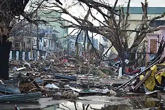
On November 7, 2013, Morgermen flew with fellow chasers James Reynolds and Mark Thomas to Tacloban City in the Philippines to intercept one of the most powerful typhoons in the 21st century: Typhoon Haiyan.
They initially planned to ride out the storm south of the city, where the eye would ultimately make landfall; however, owing to a lack of sturdy shelters they opted to stay in Tacloban itself.[4] They set up at a four-story concrete hotel about 26 ft (7.9 m) above sea level.[4][76] The chasers came prepared with a week's-worth of food and water. Around 6:45 a.m. local time, the northern eyewall began battering Tacloban and winds rapidly became violent. Morgerman described the winds to have a "tornado-like quality" at times. Windows and doors at the hotel blew out and the roof was torn off. Trees in the region were completely defoliated. Around 7:50 a.m. a powerful storm surge swept through the city, with flood waters reaching a depth of 4 ft (1.2 m) at Morgerman's location.
The fast-rising nature of the water incited panic, residents sheltering at the hotel scrambled to the building's second floor and some broke windows to escape their rooms. Morgerman jumped into the water to help people get from flooding rooms to the stairs. Thomas severely injured his leg in the water while assisting trapped people.[4]
Morgerman described the experience as traumatizing, witnessing the total devastation of Tacloban, bodies strewn across the streets, and "a city spiraling out of control".[4] The crew was stuck in Tacloban for three days, eventually "escaping" on November 10 by which time the Philippine military arrived with relief supplies.[76] Morgerman observed a minimum pressure of 959.9 mbar (28.35 inHg) in the eyewall of Haiyan. Extrapolating from his second measurement of 960.4 mbar (28.36 inHg), he estimated the central pressure to have been below 900 mbar (27 inHg).[35]
2014 Hurricane Odile
In September 2014, Morgerman intercepted Hurricane Odile in Cabo San Lucas, Mexico. Successfully entering the eye, he recorded a pressure of 943.1 mbar (27.85 inHg).[37] Operational assessments of the hurricane's landfall intensity were taken into account for the release of catastrophe bonds funded by Wall Street and the World Bank. The bond system guaranteed a payout of $50 million for a storm with a pressure under 932 mbar (27.5 inHg); Odile's operational estimate was 930 mbar (27 inHg). However, his observations "upend[ed] the system" and the bonds were rescinded. This prevented vital recovery funds from being provided to the Government of Mexico.[77] The hurricane caused extensive damage throughout Baja California Sur, with insured losses estimated at $1.2 billion.[78] Industry experts later expressed concern over possible conflicts of interest with storm chasers and the catastrophe bonds.[77][78]
2019 Hurricane Dorian
On August 31, 2019, Morgerman flew to Marsh Harbour, in the Bahamas to intercept Category 5 Hurricane Dorian.[79] Initially staging his chase in Treasure Cay, he ultimate chose to ride out the storm at Central Abaco Primary School—a designated concrete shelter—in Marsh Harbour.[80][81] At 11:40 a.m. EDT on September 1, Morgerman reported board to be flying off the structures windows and children being wrapped in blankets for safety.[82] After tweeting this information, contact with Morgerman lost for two days before he was able to contact the Weather Channel.[80]
Around 2:00 p.m. EDT, Hurricane Dorian made landfall over the Abaco Islands with maximum sustained winds of 185 mph (295 km/h), making it the strongest such storm on record in the Bahamas.[83] The eyewall of Dorian proved exceptionally violent, battering the school with "the force of a thousand sledgehammers".[84] He and others sheltering at the school held furniture against window shutters to prevent them from blowing in.[85] The school was largely destroyed in the first half of the hurricane, forcing Morgerman and those sheltering inside to evacuate to a sturdier government building during the calm of the eye.[80] During the eye, he recorded a pressure of 913.4 mbar (26.97 inHg), the lowest in his career.[65] Hundreds of residents, many injured during the storm, sought refuge in the structure for the second half of the hurricane.[80] After living in his car for two days, Morgerman arrived in Nassau by helicopter on September 3 before returning to the United States. He described Dorian as a "nuclear-grade hurricane" and "the most intense cyclone I’ve witnessed in 28 years of chasing".[80][85]
Hurricane Man
In October 2018, UKTV announced a new television docuseries starring Morgerman to be aired on the network channel Dave. The eight-episode show, titled Hurricane Man, chronicles Morgerman's chases in 2018 across the world. A film crew accompanied him on his chases. The series is produced by ScreenDog Productions and distributed by BBC Studios.[86] In addition to following Morgerman's experiences, the show also focuses on victims of the storms, sharing their experiences and how they're coping with its aftermath.[87]
Morgerman acted more carefully during his chases with the film crew present, feeling responsibility for their safety.[88] The show premiered in the United Kingdom on March 24, 2019,[87] and June 12 in Australia on BBC Knowledge.[88] The show debuted on September 15 in the United States on the Science Channel.[89] The series' first two episodes focus on 2018's Category 5 Hurricane Michael and its effects in Panama City, Florida.[88]
References
- Josh Morgerman (March 31, 2019). "Inside the Mind of a Hurricane Chaser". Outside (Interview). Interviewed by S. I. Rosenbaum. Retrieved September 7, 2019.
- "josh morgerman". iCyclone. 2019. Retrieved May 22, 2019.
- Josh Morgerman (August 27, 2012). "Hurricane chasing: While most run from the storm, iCyclone seeks the core". The Washington Post (Interview). Interviewed by Ian Livingston. Capital Weather Gang. Retrieved September 7, 2019.
- Josh Morgerman (December 4, 2013). "A heart-pounding inside look at Super Typhoon Haiyan" (Interview). Interviewed by Ian Livingston. Retrieved September 7, 2019.
- Victoria Craw (March 28, 2017). "US storm-chaser Josh Morgerman says Cyclone Debbie is 'worst case scenario'". news.com.au. Retrieved September 7, 2019.
- Daniel P. Brown (February 20, 2013). Hurricane Ernesto (AL052012) (PDF) (Report). Tropical Cyclone Report. National Hurricane Center. Retrieved September 7, 2019.
- John P. Cangialosi and Todd B. Kimberlain (March 4, 2015). Hurricane Odile (EP152014) (PDF) (Report). Tropical Cyclone Report. National Hurricane Center. Retrieved September 7, 2019.
- Daniel P. Brown and Christopher W. Landsea (September 14, 2014). Hurricane Odile Tropical Cyclone Update (Report). National Hurricane Center. Retrieved September 7, 2019.
- Todd B. Kimberlain, Eric S. Blake, and John P. Cangialosi (February 4, 2016). Hurricane Patricia (EP202015) (PDF) (Report). Tropical Cyclone Report. National Hurricane Center. Retrieved September 7, 2019.CS1 maint: multiple names: authors list (link)
- Michael J. Brennan (April 2, 2019). Hurricane Willa (EP242018) (PDF) (Report). Tropical Cyclone Report. National Hurricane Center. Retrieved September 7, 2019.
- Josh Morgerman, Andrew Hagen, Erik Sereno Trabaldo, and Jorge Abelardo González (February 3, 2016). Reanalysis of the 1959 Manzanillo hurricane (PDF) (Report). National Oceanic and Atmospheric Administration. Retrieved September 7, 2019.CS1 maint: multiple names: authors list (link)
- Robert F. Rogers, Sim Aberson, Michael M. Bell, Daniel J. Cecil, James D. Doyle, Todd B. Kimberlain, Josh Morgerman, Lynn K. Shay, and Christopher Velden (October 30, 2017). "Rewriting the Tropical Record Books: The Extraordinary Intensification of Hurricane Patricia (2015)" (PDF). Bulletin of the American Meteorological Society. 98 (10): 2, 091–2, 112. doi:10.1175/BAMS-D-16-0039.1. Retrieved September 7, 2019.CS1 maint: multiple names: authors list (link)
- "Belle 1976: My Very First Taste". iCyclone. 2019. Retrieved May 22, 2019.
- "Gloria 1985: Careful What You Wish For". iCyclone. 2019. Retrieved May 22, 2019.
- "Bob 1991: My Very First Chase". iCyclone. 2019. Retrieved May 22, 2019.
- "Bret 1999: The Real Deal". iCyclone. 2019. Retrieved May 22, 2019.
- "Wilma 2005: Ferocious Second Act". iCyclone. 2019. Retrieved May 22, 2019.
- "Dean 2007: The Thing That Went Bump in the Night". iCyclone. 2019. Retrieved May 22, 2019.
- "Dolly 2008: Howling Across the Rio Grande Valley". iCyclone. 2019. Retrieved May 22, 2019.
- "Gustav 2008: Chasing in Cajun Country". iCyclone. 2019. Retrieved May 22, 2019.
- "Ike 2008: Big, Bad Texan Cyclone". iCyclone. 2019. Retrieved May 22, 2019.
- "Jimena 2009: Grand Trek Up the Baja Peninsula". iCyclone. 2019. Retrieved May 22, 2019.
- "Alex 2010: Threading the Needle in the Dark". iCyclone. 2019. Retrieved May 22, 2019.
- "Karl 2010: Flying Debris Festival". iCyclone. 2019. Retrieved May 22, 2019.
- "Don 2011: Now You See It—Now You Don't". iCyclone. 2019. Retrieved May 22, 2019.
- "Irene 2011: Thin Slice of 1950s Nostalgia". iCyclone. 2019. Retrieved May 22, 2019.
- "Jova 2011: Violent Midnight Microcane". iCyclone. 2019. Retrieved May 22, 2019.
- "Rina 2011: When Given a Lemon, Make Lemonade". iCyclone. 2019. Retrieved May 22, 2019.
- "Ernesto 2012: Pinprick in the Night". iCyclone. 2019. Retrieved May 22, 2019.
- "Isaac 2012: Swamp Marathon". iCyclone. 2019. Retrieved May 22, 2019.
- "Ingrid 2013: Deceptively Lame Start to an Epic Season". iCyclone. 2019. Retrieved May 22, 2019.
- "Fitow 2013: Endurance Test". iCyclone. 2019. Retrieved May 22, 2019.
- "Danas 2013: Razor-thin Win". iCyclone. 2019. Retrieved May 22, 2019.
- "Nari 2013: Hit & Run". iCyclone. 2019. Retrieved May 22, 2019.
- Josh Morgerman (April 3, 2014). "Super Typhoon Haiyan in Tacloban City & Leyte, Philippines" (PDF). iCyclone. Retrieved May 22, 2019.
- "Neoguri 2014: Nasty Tease". iCyclone. 2019. Retrieved May 22, 2019.
- Josh Morgerman (2014). Odile 2014: Baja California Terror (PDF) (Report). iCyclone. Retrieved September 7, 2019.
- "Vongfong 2014: Slow, Painful Demise". iCyclone. 2019. Retrieved September 7, 2019.
- "Soudelor 2015: Mountain Mischief". iCyclone. 2019. Retrieved September 7, 2019.
- "Goni 2015: Island Roulette Jackpot!". iCyclone. 2019. Retrieved September 7, 2019.
- "Dujuan 2015: Eye Obsession". iCyclone. 2019. Retrieved September 7, 2019.
- "Patricia 2015: Cruel Queen of the East Pacific" (PDF). iCyclone. 2019. Retrieved September 7, 2019.
- "Nepartak 2016: Taiwan Typhoon Trickery". iCyclone. 2019. Retrieved September 7, 2019.
- "Earl 2016: The Caribbean Sea Annexes a City" (PDF). iCyclone. 2019. Retrieved September 7, 2019.
- "Hermine 2016: Penetrate & Conquer". iCyclone. 2019. Retrieved September 7, 2019.
- "Newton 2016: Sudden Sequel" (PDF). iCyclone. 2019. Retrieved September 7, 2019.
- "Megi 2016: Mad Dash North". iCyclone. 2019. Retrieved September 7, 2019.
- "Matthew 2016: A Close & Painful Miss". iCyclone. 2019. Retrieved September 7, 2019.
- "Haima 2016: Where There's a Will, There's a Way". iCyclone. 2019. Retrieved September 7, 2019.
- "Debbie 2017: Dangerous First Journey to Oz". iCyclone. 2019. Retrieved September 7, 2019.
- "Noru 2017: Victory by a Hair". iCyclone. 2019. Retrieved September 7, 2019.
- "Franklin 2017: Running on Empty— But Hitting the Bullseye" (PDF). iCyclone. 2019. Retrieved September 7, 2019.
- "Harvey 2017: Chaserdude's Fantasy Storm" (PDF). iCyclone. 2019. Retrieved September 7, 2019.
- "Irma 2017: Explosive Halfcane". iCyclone. 2019. Retrieved September 7, 2019.
- "Maria 2017: At the Coast, in the Right-Front Quad" (PDF). iCyclone. 2019. Retrieved September 7, 2019.
- "Nate 2017: Late-Season Surprise Rush Job" (PDF). iCyclone. 2019. Retrieved September 7, 2019.
- "Lan 2017: Honshu Express". iCyclone. 2019. Retrieved September 7, 2019.
- "Soulik 2018: Snatching Victory from Jaws of Defeat". iCyclone. 2019. Retrieved September 7, 2019.
- "Cimaron 2018: Sexy Second Act". iCyclone. 2019. Retrieved September 7, 2019.
- "Jebi 2018: Honshu Shocker". iCyclone. 2019. Retrieved September 7, 2019.
- "Mangkhut 2018: Playing with Cat-5 Fire" (PDF). iCyclone. 2019. Retrieved September 7, 2019.
- "Michael 2018: Great American Hurricane" (PDF). iCyclone. 2019. Retrieved September 7, 2019.
- "Willa 2018: Mad Dash into the Bullseye" (PDF). iCyclone. 2019. Retrieved September 7, 2019.
- "Yutu 2018: Luzon Left Hook". iCyclone. 2019. Retrieved September 7, 2019.
- Josh Morgerman [@iCyclone] (September 3, 2019). "My lowest-pressures list has a new top dog. Ain't even close. #DORIAN" (Tweet). Retrieved September 7, 2019 – via Twitter. |date= mismatches calculated date from |number= by two or more days (help)
- Josh Morgerman [@iCyclone] (October 13, 2019). "Summary of my #Typhoon #HAGIBIS chase. Went through eye. Min pressure & timing (958.5 mb at 6:40 pm) correspond well with nearby station data & JMA track. Not one for the ages—but on a side note, this marks 48th hurricane/typhoon eyewall I've penetrated (or at least touched)" (Tweet). Retrieved October 13, 2019 – via Twitter.
- Josh Morgerman [@iCyclone] (December 3, 2019). "My data from going through eye of Cat-4 #Typhoon #KAMMURI in #Legazpi City. I had 3 devices: min pressures were 961.9, 962.9, & 963.3 mb; I'm using middle value as my "official" minimum. Not as low as I'd expect from WPAC cyclone, but storm was plenty violent & "felt" like Cat 4" (Tweet). Retrieved December 4, 2019 – via Twitter.
- Josh Morgerman [@iCyclone] (July 25, 2020). "6 pm. In the eye of #Hurricane #HANNA in Port Mansfield #Texas" (Tweet). Retrieved July 25, 2020 – via Twitter.
- Josh Morgerman [@iCyclone] (August 3, 2020). "11:15 pm. Still in eye in Ocean Isle Beach #NorthCarolina, almost right smack at official 11 pm position (33.8N 78.5W). Bullseye. 990.3 mb was lowest I got (assuming elevation is correct), although it's possible I missed lowest. Slowly rising now. Still calm. #Hurricane #ISAIAS" (Tweet). Retrieved August 3, 2020 – via Twitter. |date= mismatches calculated date from |number= by two or more days (help)
- Josh Morgerman [@iCyclone] (August 27, 2020). "Got to Orange to retrieve my @KestrelWeather meter there. It had min pressure of 974.9 mb at 2:23 am. I had 948.0 mb in Sulphur about same time (2:39 am)—difference of ~27 mb across ~21 n mi. A steep gradient—not insane, but steep. Need to dig more into data. #Hurricane #LAURA" (Tweet). Retrieved August 27, 2020 – via Twitter.
- Josh Morgerman [@iCyclone] (September 17, 2020). "My data/obs from #Hurricane #SALLY in Gulf Shores #Alabama. Device was in controlled environment (hotel) ~1 n mi from me. Most notable: wild air-pressure fluctuations in fierce front eyewall & volatile boundary zone between eyewall & eye. Apparent mesovortex action. Sexy data.)" (Tweet). Retrieved September 17, 2020 – via Twitter.
- Josh Morgerman [@iCyclone] (October 7, 2020). "6:50 am. Yeah, that was the eye. The storm is starting up again. Here we go... #Hurricane #DELTA in #Cancun #Mexico" (Tweet). Retrieved October 7, 2020 – via Twitter.
- Josh Morgerman [@iCyclone] (October 9, 2020). "8:30 pm. Light, cool breeze. Scent of cut wood (a hurricane smell). Townspeople poking outside with flashlights, looking at the damage. In the eye of #Hurricane #DELTA in Estherwood #Louisiana. P.S. Min pressure was 975.9 mb at 8:02 pm. Seems to be rising now" (Tweet). Retrieved October 9, 2020 – via Twitter.
- Josh Morgerman [@iCyclone] (October 26, 2020). "11:07 pm. Pressure's inching up & it's starting to rain again in Akumal. My min value was 979.2 mb, just before 11 pm. Chasing #Hurricane #ZETA in #Mexico" (Tweet). Retrieved October 27, 2020 – via Twitter.
- Josh Morgerman [@iCyclone] (October 28, 2020). "My minimum pressure at #HurricaneHouse in Bay St. Louis #Mississippi was 979.6 mb at 7:34 pm. This was when the intense right eyewall was pounding the town with its max winds (radar shot is from 2 mins earlier). Eye stayed just W of town, so we never had calm here. #ZETA" (Tweet). Retrieved October 29, 2020 – via Twitter.
- Josh Morgerman (November 11, 2013). "5 Questions For A Seasoned Storm Chaser Who Witnessed The Wrath Of Typhoon Haiyan" (Interview). Interviewed by Tony Merevick. BuzzFeed News. Retrieved September 7, 2019.
- Jeremy Blackman, Micah Maidenberg, and Sylvia, Varnham O'Regan (April 8, 2018). "Mexico's disaster bonds were meant to provide quick cash after hurricanes and earthquakes. But it often hasn't worked out that way". The Los Angeles Times. Retrieved September 7, 2019.CS1 maint: multiple names: authors list (link)
- Robert Muir-Wood (July 4, 2017). "The Hurricane Hunter and the Cat Bond". RMS. Retrieved September 7, 2019.
- Josh Morgerman [@iCyclone] (August 31, 2019). "Goin' for it. Last flight into Abaco Islands #Bahamas before it shuts down. I passionately hate Island Roulette. But I hate standing on my hind legs for three days to lick the bland edges of an unraveling recurver even more. I may go down in flames on this chase. Oh well. #DORIAN" (Tweet). Retrieved September 7, 2019 – via Twitter.
- Joe McCarthy (September 3, 2019). "Hurricane Chaser Josh Morgerman Emerges After Days of Silence". The Weather Channel. Retrieved September 7, 2019.
- Josh Morgerman [@iCyclone] (September 1, 2019). "3:40 am. Middle-of-the-night strategy move: With #DORIAN's continued W movement, I started to feel like I'd miss the eye—so I jumped in the car & drove ~20 miles from black star (resort in Treasure Cay) to brown star (school in Marsh Harbour). May ride it out here. Ain't sure" (Tweet). Retrieved September 7, 2019 – via Twitter.
- Josh Morgerman [@iCyclone] (September 1, 2019). "11:40 am. Pounding. CRASHING. Boards prying off windows. We're moving children to a safe space, wrapping them in blankets. 969 mg. #DORIAN" (Tweet). Retrieved September 7, 2019 – via Twitter.
- Lixion Avila (September 1, 2019). Hurricane Dorian Intermediate Advisory Number 33A (Report). National Hurricane Center. Retrieved September 7, 2019.
- Josh Morgerman [@iCyclone] (September 3, 2019). "Winds pounded the building with the force of a thousand sledgehammers. Crept out during eye to find school mostly destroyed, cars in parking lot thrown around & mutilated. Barometer said 913.4 mb" (Tweet). Retrieved September 7, 2019 – via Twitter.
- Victor Garcia (September 6, 2019). "Storm chaser describes being in Bahamas for Dorian". Fox News. Retrieved September 7, 2019.
- "Hurricane Man to take Dave into the eye of the storm". UKTV. October 10, 2018. Retrieved September 7, 2019.
- Margeaux Sippell (May 15, 2019). "Science Channel to Import Josh Morgerman's UK Storm-Chasing Series 'Hurricane Man' (Exclusive)". The Wrap. Retrieved September 7, 2019.
- Brad Newsome (June 6, 2019). "The rare obsession that drove an ad man to get inside hurricanes". The Sydney Morning Herald. Retrieved September 7, 2019.
- "The Bryan Norcross Podcast: Chasing storms with 'Hurricane Man' Josh Morgerman". WPLG. August 15, 2019. Retrieved September 7, 2019.