Karaisalı
Karaisalı is a small city and a district in Adana Province of Turkey, administratively a part of the Metropolitan Municipality of Adana.
Karaisalı | |
|---|---|
 Karaisalı | |
| Coordinates: 37°48′00″N 35°57′00″E | |
| Country | Turkey |
| Province | Adana |
| Government | |
| • Mayor | Saadettin Aslan (MHP) |
| • Kaymakam | Mehmet Tunç |
| Area | |
| • District | 1,526.60 km2 (589.42 sq mi) |
| Population (2012)[2] | |
| • Urban | 7,504 |
| • District | 22,368 |
| • District density | 15/km2 (38/sq mi) |
| Post code | 017xx |
| Website | www.karaisali.bel.tr |
The area contains the reservoirs of Çatalan and Nergizlik. There is a wrestling tournament in late-April to early-May at Salbaş and a countryside festival in the last week of August at Kızıldağ.
History
In Greek and Roman times there was a city here named Midelle. During the time city was controlled by several kingdoms as Seljuk Empire and Armenian Kingdom of Cilicia. Following the arrival of the Turkish population in the area the name was changed to Çeceli and inhabited by the Yüreğir and Menemencioğulları and Ramazanoğulları tribes.
Between 1481 and 1496 the city was controlled by the Mameluks and once these had been defeated by Ottoman sultan Selim I he passed control to the Ramazanoğulları dynasty. The current name Karaisalı was later given in memory of a Ramazanoğulları lord.
The city was not occupied during the Turkish War of Independence in the early 1920s and became a centre of Turkish resistance for the Çukurova area.
Karaisalı today
Long-term mayor of Adana, Aytaç Durak is from Karaisalı and during his term the district was included in the Metropolitan Municipality of Adana.
Places of interest
- The Roman built Milvan Castle in the village of Karakılıç.
- The silk road caravanserai Kesiri Han in the village of Altınova.
- Another Roman castle Keçi Kalesi 40 km north-east of Karaisalı in the village of Etekli. has commanding views from its hill-top position.
- The wooded hillside picnic areas of Yerköprü and Kızıldağ in particular Kapıkaya Canyon.
- The attractive remote village of Kalayçılar. 7 km from the village of Hacılı on a dirt road.
- Turkey's highest bridge, the 172 m (564 ft) long and 93 m (305 ft) high German built railway viaduct Varda Bridge in the village of Hacıkırı (Kıralan).
- The Fish restaurant in Demirçit or otherwise known as Bolagat.
References
| Wikimedia Commons has media related to Karaisalı. |
- "Area of regions (including lakes), km²". Regional Statistics Database. Turkish Statistical Institute. 2002. Retrieved 2013-03-05.
- "Population of province/district centers and towns/villages by districts - 2012". Address Based Population Registration System (ABPRS) Database. Turkish Statistical Institute. Retrieved 2013-02-27.
Karaisalı in Adana Province of Turkey | |||||||||||||||||||||||||||
|---|---|---|---|---|---|---|---|---|---|---|---|---|---|---|---|---|---|---|---|---|---|---|---|---|---|---|---|
| Districts | 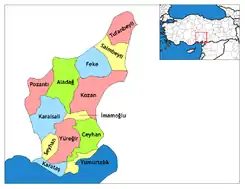 Districts of Adana | ||||||||||||||||||||||||||
| |||||||||||||||||||||||||||
Metropolitan municipalities are bolded. | |||||||||||||||||||||||||||