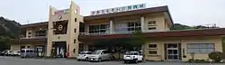
Kawauchi, Fukushima
Kawauchi (川内村, Kawauchi-mura) is a village located in Fukushima Prefecture, Japan. As of 1 January 2020, the village had an official registered population of 1,861, and a population density of 9.5 persons per km². The total area of Kawauchi is 197.35 square kilometres (76.20 sq mi).[1] The village was evacuated as a result of the 2011 Fukushima Daiichi nuclear disaster, but in 2014, all restrictions were lifted.
Kawauchi
川内村 | |
|---|---|
 | |
Flag Seal | |
Location of Kawauchi in Fukushima Prefecture | |
 Kawauchi | |
| Coordinates: 37°20′15″N 140°48′34″E | |
| Country | Japan |
| Region | Tōhoku |
| Prefecture | Fukushima |
| District | Futaba |
| Area | |
| • Total | 197.35 km2 (76.20 sq mi) |
| Population (January 1, 2020) | |
| • Total | 1,861 |
| • Density | 9.4/km2 (24/sq mi) |
| Time zone | UTC+9 (Japan Standard Time) |
| - Tree | Abies firma |
| - Flower | Enkianthus campanulatus |
| - Bird | Japanese bush-warbler |
| Phone number | 0240-38-2111 |
| Address | Kamikawauchi, Kawauchi-mura, Futaba-gun, Fukushima-ken 979-1292 |
| Website | Official website |
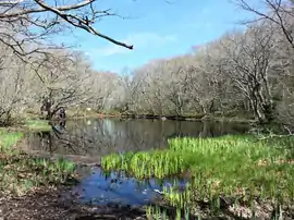
Geography
Kawauchi is located in the Abukuma Plateau of central Fukushima with a mean altitude of between 400 and 500 meters. North of Kawauchi, there is at 37°22′53″N 140°48′16″E a substation of Kita–Iwaki powerline, a 500 kV-line already designed for future 1100 kV operation.
Demographics
Per Japanese census data,[2] the population of Kawauchi has declined steadily over the past 60 years and is now almost half what it was a century ago.
| Year | Pop. | ±% |
|---|---|---|
| 1920 | 5,573 | — |
| 1930 | 4,275 | −23.3% |
| 1940 | 4,540 | +6.2% |
| 1950 | 5,930 | +30.6% |
| 1960 | 5,966 | +0.6% |
| 1970 | 4,709 | −21.1% |
| 1980 | 4,132 | −12.3% |
| 1990 | 3,933 | −4.8% |
| 2000 | 3,384 | −14.0% |
| 2010 | 2,821 | −16.6% |
Climate
Kawauchi has a humid continental climate (Köppen Cfa) characterized by mild summers and cold winters with heavy snowfall. The average annual temperature in Kawauchi is 10.3 °C. The average annual rainfall is 1431 mm with September as the wettest month. The temperatures are highest on average in August, at around 22.5 °C, and lowest in January, at around -0.7 °C.[3]
History
The area of present-day Kawauchi was part of Mutsu Province. After the Meiji restoration, on April 1, 1889, the village of Kawauchi was created within Futaba District, Fukushima with the establishment of the modern municipalities system.
2011 Fukushima Daiichi nuclear disaster
Kawauchi suffered moderate damage from the 2011 Tōhoku earthquake and tsunami. However, the eastern portion of the village is located within the nominal 20-kilometer exclusion zone of the Fukushima Daiichi nuclear power plant, and as a result of wind patterns following the Fukushima Daiichi nuclear disaster, the entire population of the village was evacuated by government order by May 2011. A portion of the village was re-opened in March 2012.[4][5]
In August 2014, the government divided the remaining portion of the village into two zones, and projected a lifting of the evacuation order for 275 residents in one of the zones in October.[6]
Economy
The economy of Kawauchi was formerly heavily dependent on agriculture.
Education
Kawauchi had two high schools (one public, one private), one junior high school, one elementary school, and a kindergarten in March 2011. After the evacuation and re-opening of the town both high schools were closed. The junior high school, elementary school, and kindergarten remain open.
References
- "Home Page" (in Japanese). Katsurao Village. Retrieved 6 February 2015.
- Kawauchi population statistics
- Kawauchi climate data
- "Japan reopens parts of Fukushima evacuation zone", The Guardian, March 30, 2012.
- NHK-World (16 April 2012) Govt. lifts evacuation order for Minamisoma City Archived 2015-02-10 at the Wayback Machine
- Myoraku, Asao "Second group of Fukushima residents given OK to return home in evacuation zone", Archived 2015-02-16 at the Wayback Machine The Asahi Shimbun, August 18, 2014.
External links
![]() Media related to Kawauchi, Fukushima at Wikimedia Commons
Media related to Kawauchi, Fukushima at Wikimedia Commons
- Official Website (in Japanese)
| Core cities | ||
|---|---|---|
| Cities | ||
| Districts | ||
| Authority control |
|---|