Kitashiobara, Fukushima
Kitashiobara (北塩原村, Kitashiobara-mura) is a village located in Fukushima Prefecture, Japan. As of 1 April 2020, the village had an estimated population of 2,697 in 1091 households,[1] and a population density of 12 persons per km². The total area of the village was 234.08 square kilometres (90.38 sq mi).
Kitashiobara
北塩原村 | |
|---|---|
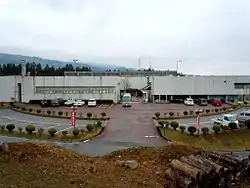 Kitashiobara Village Hall | |
Flag Seal | |
Location of Kitashiobara in Fukushima Prefecture | |
 Kitashiobara | |
| Coordinates: 37°39′20.4″N 139°56′15.4″E | |
| Country | Japan |
| Region | Tōhoku |
| Prefecture | Fukushima |
| District | Yama |
| Area | |
| • Total | 234.08 km2 (90.38 sq mi) |
| Population (April 2020) | |
| • Total | 2,697 |
| • Density | 12/km2 (30/sq mi) |
| Time zone | UTC+9 (Japan Standard Time) |
| - Tree | Prunus sargentii |
| - Flower | Lysichiton camtschatcensis |
| - Bird | Japanese tit |
| Phone number | 0241-23-3111 |
| Address | 3151 Kitayama Kitashiobara-mura, Yama-gun, Fukushima-ken 966-0485 |
| Website | Official website |
Geography
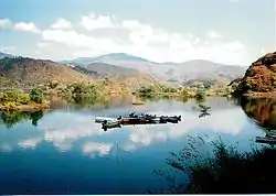
Kitashiobara is located at the far northern Aizu region of Fukushima Prefecture, bordered by Yamagata Prefecture to the north. Kitashiobara consists of three areas, named after the former the villages of Kitayama, Ōshio, and Hibara. The western portion, Hibara, has a higher elevation than the other two areas, most of it between 800 m and 1000 m. Also, Lake Hibara in Hibara is located in the Bandai-Asahi National Park. It was created in 1888 during the eruption of Mount Bandai. Oguni-numa, a swamp, is reserved by the Japanese government as a natural monument.[2] Some 86% of the village area is covered in mountains and forest.
- Mountains : Mount Bandai
- Rivers : Nakutsu-gawa, Ono-gawa
- Lakes : Lake Hibara, Goshiki-numa, Lake Onogawa, Oguni-numa, Akimoto Lake
Neighboring municipalities
Fukushima Prefecture
Yamagata Prefecture
Climate
Kitashiobara has a Humid continental climate (Köppen Dfb) characterized by warm summers and cold winters with heavy snowfall. The average annual temperature in Kitashiobara is 7.4 °C. The average annual rainfall is 1666 mm with September as the wettest month. The temperatures are highest on average in August, at around 20.8 °C, and lowest in January, at around -4.9 °C.[3]
Demographics
Per Japanese census data,[4] the population of Kitashiobara has declined steadily over the past 40 years.
| Year | Pop. | ±% |
|---|---|---|
| 1920 | 4,482 | — |
| 1930 | 4,368 | −2.5% |
| 1940 | 4,375 | +0.2% |
| 1950 | 5,284 | +20.8% |
| 1960 | 5,351 | +1.3% |
| 1970 | 4,287 | −19.9% |
| 1980 | 3,869 | −9.8% |
| 1990 | 3,812 | −1.5% |
| 2000 | 3,644 | −4.4% |
| 2010 | 3,185 | −12.6% |
History
The area of present-day Kitashiobara was part of ancient Mutsu Province, and formed part of the holdings of Aizu Domain during the Edo period. After the Meiji Restoration, it was organized as part of Yama District, Fukushima Prefecture. The villages of Kitayama, Ōshio and Hibara. were created with the establishment of the modern municipalities system on April 1, 1884. The three villages merged to form the village of Kitashiobara village was created on March 31, 1954.
Economy
The economy of Kitashiobara is dependent on agriculture, seasonal tourism, and the mining of salt.
Education
Kitashiobara has two public elementary schools and two public junior high schools operated by the village government. The village does not have a public high school.
Transportation
Railway
- Kitashiobara does not have any passenger rail service.
Highway
Local attractions
External links
![]() Media related to Kitashiobara, Fukushima at Wikimedia Commons
Media related to Kitashiobara, Fukushima at Wikimedia Commons
- Official Website (in Japanese)
Notes
| Core cities | ||
|---|---|---|
| Cities | ||
| Districts | ||
| Authority control |
|---|