Minamiaizu
Minamiaizu (南会津町, Minamiaizu-machi) is a town located in Fukushima Prefecture, Japan. As of 1 April 2020, the town had an estimated population of 15,158 in 6,575 households,[1] and a population density of 17 persons per km². The total area of the town was 886.52 square kilometres (342.29 sq mi).
Minamiaizu
南会津町 | |
|---|---|
 Minamiaizu Town Hall | |
Flag Seal | |
Location of Minamiaizu in Fukushima Prefecture | |
 Minamiaizu | |
| Coordinates: 37°12′1.4″N 139°46′23.6″E | |
| Country | Japan |
| Region | Tōhoku |
| Prefecture | Fukushima |
| District | Minamiaizu |
| Area | |
| • Total | 886.47 km2 (342.27 sq mi) |
| Population (April 2020) | |
| • Total | 15,158 |
| • Density | 17/km2 (44/sq mi) |
| Time zone | UTC+9 (Japan Standard Time) |
| Phone number | 0241-62-6100 |
| Address | 3531-1 Tajima Gohara, Minamiaizu-machi, MInamiaizu-gun, Fukushima-ken 967-0004 |
| Website | Official website |
.jpg.webp)
Geography
Minamiaizu is located in the mountainous southern portion of the Aizu region of Fukushima Prefecture, bordered Tochigi Prefecture to the south.
- Mountains : Onsabi Mountains, Nasudake, Mount Nanatsugadake
- Rivers : Okawa, Ina River
Demographics
Per Japanese census data,[2] the population of Minamiaizu peaked I the 1950s and has declined steadily over the past 40 years. It is now less than it was a century ago.
| Year | Pop. | ±% |
|---|---|---|
| 1920 | 20,204 | — |
| 1930 | 23,020 | +13.9% |
| 1940 | 28,057 | +21.9% |
| 1950 | 31,946 | +13.9% |
| 1960 | 34,152 | +6.9% |
| 1970 | 26,813 | −21.5% |
| 1980 | 24,119 | −10.0% |
| 1990 | 22,548 | −6.5% |
| 2000 | 21,095 | −6.4% |
| 2010 | 17,850 | −15.4% |
Climate
Minamiaizu has a Humid continental climate (Köppen Dfb) characterized by warm summers and cold winters with heavy snowfall. The average annual temperature in Minamiaizu is 8.8 °C. The average annual rainfall is 1642 mm with September as the wettest month. The temperatures are highest on average in August, at around 24.8 °C, and lowest in January, at around -3.4 °C.[3]
History
The area of present-day Minamiaizu was part of ancient Mutsu Province and formed part of the holdings of Aizu Domain during the Edo period. After the Meiji Restoration, it was organized as part of Minamiaizu District in Fukushima Prefecture. With the establishment of the modern municipalities system on April 1, 1889, the town of Tajima and the villages of Ina, Nangō, and Tateiwa were established with the creation of the modern municipalities system. These four municipalities merged on March 20, 2006 to form the town of Minamiaizu.
Economy
The economy of Minamiaizu is primarily agricultural. Rice, tomatoes and asparagus are the main crops.
Education
The town has seven public elementary schools and four public junior high school operated by the town government. The town has two public high schools operated by the Fukushima Prefectural Board of Education.
- Fukushima Prefectural Tajima High School
- Fukushima Prefectural Minamiaizu High School
Transportation
Railway
- Aizu-Nagano - Tajimakōkōmae - Aizu-Tajima - Nakaarai - Aizu-Arakai - Aizu-Sanson-Dōjō - Nanatsugatake-Tozanguchi - Aizukōgen-Ozeguchi
■ Yagan Railway – Aizu Kinugawa Line
Local attractions
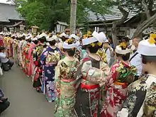
- Aizu-Tajima Gionsai festival
- Okuaizu Museum
- Komado Wetlands
- Tashiroyama Wetlands
- Yunohana Onsen
- Hosoi Residence Museum
- Maezawa Magariya Village (Museum of "L" Shaped Old Folk Houses)
Noted people from Minamiaizu
- Kozo Watanabe, politician
References
External links
 Media related to Minamiaizu, Fukushima at Wikimedia Commons
- Official Website (in Japanese)
| Core cities | ||
|---|---|---|
| Cities | ||
| Districts | ||
| Authority control |
|---|