Killarney, Ontario
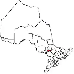
Killarney is a municipality located on the northern shore of Georgian Bay in the Sudbury District of Ontario, Canada. Killarney is commonly associated with Killarney Provincial Park, which is a large wilderness park located to the east of the townsite which occupies much of the municipality's expanded boundary.
Killarney
Shebahonaning “Safe Canoe Passage” | |
|---|---|
Village | |
| Municipality of Killarney | |
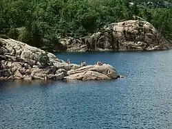 George Lake in Killarney | |
 | |
| Coordinates: 45°59′N 81°31′W | |
| Country | Canada |
| Province | Ontario |
| District | Sudbury |
| Incorporated | January 1, 1999 |
| Government | |
| • Type | Town |
| • Mayor | Ginny Rook |
| • Governing Body | Killarney Municipal Council |
| • MP | Marc Serré (Liberal) |
| • MPP | France Gélinas (NDP) |
| Area | |
| • Land | 1,653.32 km2 (638.35 sq mi) |
| Population (2016)[1] | |
| • Total | 386 |
| • Density | 0.2/km2 (0.5/sq mi) |
| Time zone | UTC-5 (EST) |
| • Summer (DST) | UTC-4 (EDT) |
| Area code(s) | 705 |
| Website | Municipality of Killarney |
In addition to the community of Killarney itself, the communities of Hartley Bay and Bigwood, and the ghost towns of French River, Collins Inlet and Key Harbour, are also located within the municipal boundaries.
The eastern end of the La Cloche Mountain Range is also located within the municipality of Killarney.
History
The original name of the community is Shebahonaning, and it one of the oldest settlements on the north shore of Lake Huron. The name of the community was changed from Shebahonaning to Killarney around the mid-19th century for reasons that are unknown but were likely tied to settler-colonial policies of re-naming as a means to establish authority.
In 1820 a French Canadian fur trader Étienne Augustin de Lamorandière and his Anishinaabe wife Josephte Saisaigonokwe arrived and established a permanent trading post in the community. Although there was already an existing settlement here at that time they are credited with the founding of the settlement.
Killarney was operated as a fishing camp by the Fruehauf Trailer Company in Detroit, Michigan. Roy Fruehauf, president of the company from 1949 to 1961, was primarily responsible for operating Killarney. Clients and guests would be flown in via Mallard sea planes for vacations during the warmer summer months.
Highway 637, connecting Killarney to Highway 69, was constructed in 1962.[2] Prior to its construction, the community relied primarily on water transport via Georgian Bay and the North Channel.
The current municipality was incorporated on January 1, 1999, when the Ontario provincial government expanded the boundaries of the township of Rutherford and George Island, the former governing body of the community of Killarney. The municipality was also transferred from the Manitoulin District to the Sudbury District at that time. In 2006, the municipality was enlarged again when it annexed the unorganized mainland portion of Manitoulin District.[3]
The larger municipality of Killarney now encompasses virtually all of Killarney Provincial Park and the French River delta, and in fact extends all the way to Highway 69, over 70 kilometres from the townsite. Despite the municipality's geographic size, however, most of its population continues to reside in the community of Killarney itself, although smaller settlements also exist at Hartley Bay and Bigwood.
Townships
The municipal boundaries of Killarney encompass the geographic townships of Rutherford and George Island, Hansen, Goschen, Sale, Attlee, Kilpatrick, Travers, Struthers, Allen, Bigwood, Killarney, Humboldt and Carlyle, and the northern part of Henvey.
The township of Hansen was originally named Stalin after Joseph Stalin, but was renamed in 1986 when Ontario MPP Yuri Shymko successfully had a private member's bill passed through the Legislative Assembly of Ontario to rename the township in the honour of athlete Rick Hansen, who was in the midst of his international Man in Motion tour at the time.[4] This legislative initiative was prompted by the work of the Ukrainian Canadian Civil Liberties Association and in particular through the efforts of Dr Lubomyr Luciuk and Dr Bohdan S Kordan.
Economy
The Killarney area's economy is based primarily on tourism, consisting mainly of wilderness lodges, campgrounds and retail services geared toward campers and other visitors to Killarney Provincial Park.
A community museum, the Killarney Centennial Museum, is located in Killarney adjacent to the municipal government offices. One tourism website listed 21 things to do in the area, although much of the content is related to the provincial park.[5]
Although not officially part of the Sudbury East region, Killarney participates in the regional Sudbury East Planning Board with the municipalities of French River, St. Charles and Markstay-Warren.
Killarney Provincial Park is also home to the Killarney Provincial Park Observatory.
During spring and summer 2020, the area's tourism was suffering because of the COVID-19 pandemic in Canada and restrictions on travel to Canada from other countries, including the US.
Transportation
The primary road access to Killarney is via Highway 637. The town is also served by the small Killarney Airport. It is also possible to travel to Killarney by boat, usually from the town of Little Current.
Demographics
| Year | Pop. | ±% |
|---|---|---|
| 1996 | 738 | — |
| 2001 | 428 | −42.0% |
| 2006 | 454 | +6.1% |
| 2011 | 505 | +11.2% |
| 2016 | 386 | −23.6% |
| [1] | ||
| Canada census – Killarney, Ontario community profile | |||
|---|---|---|---|
| 2016 | 2011 | 2006 | |
| Population: | 386 (-23.6% from 2011) | 505 (+11.2% from 2006) | 454 (+6.1% from 2001) |
| Land area: | 1,653.32 km2 (638.35 sq mi) | 1,654.58 km2 (638.84 sq mi) | 1,513.58 km2 (584.40 sq mi) |
| Population density: | 0.2/km2 (0.52/sq mi) | 0.3/km2 (0.78/sq mi) | 0.3/km2 (0.78/sq mi) |
| Median age: | 57.3 (M: 57.9, F: 56.5) | 48.2 (M: 46.6, F: 49.1) | |
| Total private dwellings: | 388 | 400 | 590 |
| Median household income: | $58,368 | $50,960 | |
| References: 2016[6] 2011[7] 2006[8] earlier[9] | |||
See also
References
- "Census Profile, 2016 Census: Killarney, Ontario". Statistics Canada. Retrieved July 9, 2019.
- Rainbow Country Travel Association
- "Annual changes to census subdivision codes, names and types, between 2006 and 2011, by province and territory, and by year". Standard Geographical Classification (SGC) 2011. Statistics Canada. Retrieved 2012-02-22.
- "Wheelchair hero circles the globe". The Free Lance-Star. Fredericksburg, Va. AP. 1986-11-08. Retrieved 28 May 2012.
- 21 Sites, Sights and Things to do in Killarney, Ontario
- "2016 Community Profiles". 2016 Canadian Census. Statistics Canada. February 21, 2017. Retrieved 2019-07-09.
- "2011 Community Profiles". 2011 Canadian Census. Statistics Canada. July 5, 2013. Retrieved 2012-02-22.
- "2006 Community Profiles". 2006 Canadian Census. Statistics Canada. March 30, 2011. Retrieved 2012-02-22.
- "2001 Community Profiles". 2001 Canadian Census. Statistics Canada. February 17, 2012.
External links
| Wikivoyage has a travel guide for Killarney (Ontario). |
Places adjacent to Killarney, Ontario | |
|---|---|
| Towns | 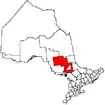 | |
|---|---|---|
| Townships | ||
| First Nations | ||
| Indian reserves | ||
| Unorganized area | ||
| Local services boards | ||
| ||
