Kokshetau
Kokshetau (meaning Blueish Mountain in Kazakh, Kazakh: Көкшетау, romanized: Kókshetaý; [køkɕetɑw] (![]() listen), Russian: Кокшета́у, pronounced [kokʂɪˈtaʊ]), formerly known as Kokchetav (1827–1993), is a city in northern Kazakhstan and the capital of Akmola Region, lying in the north of Kokshetau hills, on the southern shores of Lake Kopa and the southern edge of the Esil (Ishim) Steppe. It is also situated at the junction of the Trans-Kazakhstan and South Siberian railways. Kokshetau lies at an elevation of approximately 234 m (768 ft) above sea level.
listen), Russian: Кокшета́у, pronounced [kokʂɪˈtaʊ]), formerly known as Kokchetav (1827–1993), is a city in northern Kazakhstan and the capital of Akmola Region, lying in the north of Kokshetau hills, on the southern shores of Lake Kopa and the southern edge of the Esil (Ishim) Steppe. It is also situated at the junction of the Trans-Kazakhstan and South Siberian railways. Kokshetau lies at an elevation of approximately 234 m (768 ft) above sea level.
Kokshetau
Kókshetaý | |
|---|---|
| Kazakh transcription(s) | |
| • Cyrillic script | Көкшетау |
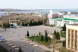 Kokshetau's central Ablai Khan Square | |
 Coat of arms | |
Nicknames:
| |
| Anthem: none | |
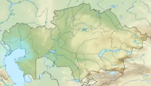 Kokshetau Location of Kokshetau in Kazakhstan  Kokshetau Kokshetau (Asia) | |
| Coordinates: 53°17′N 69°23′E | |
| Country | |
| Region | Akmola Region |
| Founded | 29 April 1824 |
| City status since | 1895 |
| Government | |
| • Akim (mayor) | Amangeldy Smailov[1] |
| Area | |
| • City | 234 km2 (90 sq mi) |
| • Urban | 425 km2 (164 sq mi) |
| Elevation | 234 m (768 ft) |
| Population (mid-2020 est.)[2] | |
| • City | 146 104 people |
| • Rank | 18th in Kazakhstan |
| • Density | 624/km2 (1,620/sq mi) |
| • Urban | 160 431 people |
| Demonym(s) | Көкшетаулық (kk) Кокшетауцы (ru) Кокшетауец (ru, male) Кокшетаука (ru, female) |
| Demographics (mid-2020 est.)[3] | |
| • Kazakhs | 58.05% |
| • Russians | 29.41% |
| • Ukrainians | 2.88% |
| • Tatars | 2.28% |
| • Germans | 1.95% |
| • Poles | 1.40% |
| • Ingush | 1.07% |
| • Other | 2.96% |
| Time zone | UTC+06:00 (ALMT) |
| Postal code | 020000–020010 |
| Area code(s) | +7 7162 |
| Vehicle registration | 03 (region) (C – on older plates) |
| Sister cities | Waukesha, Wisconsin |
| Climate | BSk |
| Highways | |
| International airports | Kokshetau (KOV) |
| Major railway stations | |
| KATO ID | 111010000[4] |
| Website | www.kokshetau.kz |
It has 146,104 inhabitants (2020 estimate), up from 123,389 (1999 census), while Akmola Region had a total population of 738,587 (2019 estimate), down from 1,061,820 (1989 census), making it the tenth most populous region in Kazakhstan. Kokshetau retains multiethnic population, with 58% ethnic Kazakhs (up from 36%), the rest being mostly 29% ethnic Russians (down from 42%) and other ethnic groups such as Ukrainian, Tatars and Germans. Kokshetau city administration (area of 425 km2 [164 sq mi]) includes one settlement administration (which consists of the village of Stantsyonny) and the Krasnoyarsk rural district, which includes two rural settlements (the villages of Krasny Yar and Kyzyl Zhulduz).
The city is considered to have been founded in 1824 as a military fortress, while it was granted city status in 1895. It is well known for its nature and tourist sites, such as Burabay and Zerenda, among others. Kokshetau is about 185 km (115 mi) from Petropavl, 300 km (190 mi) northwest of the national capital Nur-Sultan, 318 km (198 mi) from Omsk, and 384 km (239 mi) from Kostanay. The city is served by Kokshetau Airport.
Names and etymology
The name Kokshetau (Kazakh: Kókshetaý; pronounced [køkɕetɑw]) is of Kazakh origin literally meaning a (lit. 'smoky-blue mountain'), kokshe / "көкше", meaning (lit. 'blueish') and tau / "тау", meaning (lit. 'mountain') — the name of always turning blue, as if in a deep haze of mountains. That is how from ancient times Kazakhs were calling the highest mountain in Akmola Region “Mount Kokshe” (947 m), located 60 miles away from the city.
Following the collapse of the Soviet Union and independence of Kazakhstan, on October 7, 1993, by the Resolution of the Presidium of the Supreme Council of the Republic of Kazakhstan, the city of Kokchetav (Russian: Кокчета́в, IPA: [koktɕɪˈtav]) was renamed to the more Kazakh sounding Kokshetau as part of the government's campaign to apply Kazakh names to cities, but the city's airport still retains KOV as its IATA code.
Geography
Location
Kokshetau is located on the shore of Lake Kopa in the north of the Kokshetau Upland, the foothills of which surround the city from the south and west. It is located about 300 kilometres (190 mi) north-west of the national capital of Nur-Sultan. There are numerous hills in the vicinity of the city (Bukpa Hill). The Kokshetau area is known for its two national parks, Burabay and Kokshetau.
Time
The time offset from the UTC used by Kokshetau is 6 hours after UTC, or UTC+6:00 (ALMT). This is also used by most of Kazakhstan. This time apply throughout the year as Kazakhstan does not observe Daylight Saving Time (DST).
Climate
Kokshetau lies in a cold semi-arid climate (Köppen climate classification: BSk) zone with extreme continental influences. The city has long, cold winters and warm, sunny summers. The average annual temperature in Kokshetau is 3.6 °C (38.5 °F).
The warmest month is July with daily mean temperature near 20.5 °C (68.9 °F), and the coldest month is January, with a daily mean of −14 °C (7 °F). Snow and ice are dominant during the winter season. July is the wettest month (averaging 68.5 mm (2.7 in) of precipitation) while March is the driest (averaging 10.5 mm (0.4 in) of precipitation). Yearly precipitation amounts to 313 mm (12.3 in).
| Climate data for Kokshetau | |||||||||||||
|---|---|---|---|---|---|---|---|---|---|---|---|---|---|
| Month | Jan | Feb | Mar | Apr | May | Jun | Jul | Aug | Sep | Oct | Nov | Dec | Year |
| Record high °C (°F) | 4.8 (40.6) |
6.2 (43.2) |
23.1 (73.6) |
31.3 (88.3) |
35.5 (95.9) |
40.4 (104.7) |
41.7 (107.1) |
41.2 (106.2) |
36.2 (97.2) |
25.3 (77.5) |
19.2 (66.6) |
6.6 (43.9) |
41.7 (107.1) |
| Average high °C (°F) | −6 (21) |
−5.6 (21.9) |
1.2 (34.2) |
10.8 (51.4) |
19.3 (66.7) |
23.5 (74.3) |
26.7 (80.1) |
23.7 (74.7) |
17.9 (64.2) |
10.2 (50.4) |
0.3 (32.5) |
−5.1 (22.8) |
9.7 (49.5) |
| Daily mean °C (°F) | −14 (7) |
−14.5 (5.9) |
−7 (19) |
5.5 (41.9) |
13.8 (56.8) |
19.5 (67.1) |
20.5 (68.9) |
18.5 (65.3) |
12.5 (54.5) |
4.8 (40.6) |
−5.3 (22.5) |
−11.5 (11.3) |
3.6 (38.4) |
| Average low °C (°F) | −28.5 (−19.3) |
−30 (−22) |
−18.2 (−0.8) |
−1.3 (29.7) |
8.2 (46.8) |
14.5 (58.1) |
15.6 (60.1) |
14.3 (57.7) |
7.3 (45.1) |
−1.5 (29.3) |
−15.6 (3.9) |
−26.1 (−15.0) |
−5.1 (22.8) |
| Record low °C (°F) | −46.6 (−51.9) |
−48.3 (−54.9) |
−35.7 (−32.3) |
−24.7 (−12.5) |
−8.7 (16.3) |
−0.8 (30.6) |
3.4 (38.1) |
−1.3 (29.7) |
−7.6 (18.3) |
−24.8 (−12.6) |
−37.1 (−34.8) |
−42.3 (−44.1) |
−48.3 (−54.9) |
| Average precipitation mm (inches) | 12.8 (0.50) |
11.3 (0.44) |
10.5 (0.41) |
17.9 (0.70) |
32.7 (1.29) |
40.2 (1.58) |
68.5 (2.70) |
43.6 (1.72) |
24.8 (0.98) |
22.8 (0.90) |
15.7 (0.62) |
11.7 (0.46) |
312.5 (12.3) |
| Average rainy days | 3.7 | 3.4 | 3.0 | 4.2 | 6.5 | 6.5 | 8.5 | 7.3 | 5.5 | 6.2 | 4.3 | 3.3 | 62.4 |
| Average snowy days | 25 | 23 | 19 | 6 | 1 | 0 | 0 | 0 | 1 | 7 | 18 | 24 | 124 |
| Average relative humidity (%) | 78.0 | 79.0 | 77.0 | 64.0 | 53.0 | 57.0 | 68.0 | 64.0 | 68.0 | 75.0 | 83.0 | 81.0 | 71.0 |
| Mean monthly sunshine hours | 89.0 | 127.0 | 196.0 | 227.0 | 277.0 | 306.0 | 313.0 | 250.0 | 190.0 | 118.0 | 88.0 | 75.0 | 2,256 |
| Average ultraviolet index | 1 | 1 | 2 | 4 | 5 | 7 | 7 | 6 | 4 | 2 | 1 | 0 | 3 |
| Source: NOAA[5] and Weather Atlas[6] | |||||||||||||
History
_-_1890_(panoramic_view%252C_Aqmola_Region%252C_Kazakhstan).jpg.webp)

Kokshetau has a rich centuries-old past, which has incorporated all the main stages and turning points of the history of Kazakhstan. For many centuries, nomadic Kazakh tribes lived on the territory of the former Kokshetau Region. The territory of Kokshetau was part of the Middle Horde, the clans of the tribal union of the Argyns that occupied vast regions of Northern and Central Kazakhstan.[7] In the 18th – 19th centuries, the headquarters of famous khans, such as Abylai Khan, Kasym Khan, Kenesary Khan, were located on the land of Kokshetau Region.
Kokshetau was founded on April 29, 1824 by Cossacks as an administrative outpost at the foot of the southern side of Mount Kokshe on the shores of Lake Ulken Shabakty. The local population strongly opposed the fact that the new settlement was placed in the chosen place. In the summer of 1827, the district order was transferred to the new place where the city of Kokshetau is now located. The settlement began to be called Kokchetav. The construction of the settlement began at the foot of Bukpa Hill, on the shores of Lake Kopa, and a Cossack picket was set up to protect the district order.[8]
By the middle of 19th-century, the population of the settlement was significantly increasing due to the migration of the peasants from Russia (Povolzhye) and Ukraine who were driven to migrate by starvation and poverty. In 1868, when the Akmolinsk Oblast was formed, Kokshetau became a district city in this region, which further developed as a center of agricultural and animal husbandry and as a resort town. In 1876, the city lost its military significance. The line and fortress were abolished. In 1895, Kokshetau was granted city status.[9] By that time the population in the town was above 5 thousand people.[10]
In 1928, Kokshetau District was divided into several boroughs and until 1944 Kokshetau's territory was part of Karaganda Region and later part of North Kazakhstan Region. On March 16, 1944, according to the Decree of the Presidium of Supreme Soviet of Kazakh SSR, Kokshetau became the administrative center of the newly created Kokchetav Oblast. Relatively rapid growth and development of Kokshetau took place during the years of development of virgin lands, especially in the second half of the 1950s.[11] In the spring of 1997, Kokshetau Oblast was abolished, the city was deprived of the status of a regional center. On April 8, 1999, after Akmola and North Kazakhstan regions were reorganized, Kokshetau became the center of Akmola Region.[12]
Demographics
| Year | Pop. | ±% |
|---|---|---|
| 2010 | 136,100 | — |
| 2011 | 137,217 | +0.8% |
| 2012 | 136,835 | −0.3% |
| 2013 | 139,063 | +1.6% |
| 2014 | 140,847 | +1.3% |
| 2015 | 142,411 | +1.1% |
| 2016 | 145,795 | +2.4% |
| 2017 | 145,531 | −0.2% |
| 2018 | 145,789 | +0.2% |
| 2019 | 145,161 | −0.4% |
| 2020 | 146,104 | +0.6% |
| Source: Kokshetau, Kazakhstan: Historical statistics – Population | ||
Kokshetau is an ethnically and culturally diverse city. Kokshetau ranks fifth in terms of population in Northern Kazakhstan. It has changed its demographics, nowadays having more ethnic Kazakhs in a city that formerly had a Slavic majority. It is the only regional center in Northern Kazakhstan where Kazakhs make up the majority.
Population
As of January 2020, the population of Kokshetau is 146,104, and the extended urbanized area has 160,431 inhabitants.
As of the 2020 Census, ethnic Kazakhs made up 58.05% of the city population, representing an increase from 36% in 1999. The ethnic makeup of the city's population as of year 2020 was:[13]
| Ethnicity | Number | Percentage |
|---|---|---|
| Kazakhs | 93,126 | 58.05% |
| Russians | 47,185 | 29.41% |
| Ukrainian | 4,618 | 2.88% |
| Tatars | 3,660 | 2.28% |
| Volga Germans | 3,124 | 1.95% |
| others | – | 5.43% |
In 1989, Kokshetau had a population of 136,757. The ethnic mix was about 18.5% Kazakh, 53% Russian and 28.5% other ethnic groups.
| Ethnicity | Number | Percentage |
|---|---|---|
| Russians | 74,481 | 53% |
| Kazakhs | 25,300 | 18.5% |
| others | – | 28.5% |
Religion
The city's religious profile is highly diverse. Islam is the predominant religion within Kokshetau. Other religions practiced are Christianity (primarily Russian Orthodox, Roman Catholicism, and Protestantism). Kokshetau has a beautiful mosque constructed in the beginning of the 20th century and a Russian Orthodox Church temple of Archangel Michael. In 1997, a Roman Catholic Church was built in neo-Gothic style using red bricks. A new mosque for 1,200 people named after Nauan Hazrat opened in 2015 and construction of a new Orthodox Church is underway.
Industry
Large industrial enterprises of Kokshetau: gold mining enterprise JSC "Altyntau Kokshetau"; JSC "Tynys" – the production of medical products, weighing equipment, water meters, aircraft units and assemblies, polyethylene pipes; machine-building plant OJSC "KamAZ-Engineering"; JSC "Kokshetauminvody". Food factories supply Kokshetau and Akmola Region with sausages, semi-finished meat products, bread, dairy products, and confectionery. The city also has a gold recovery factory and a new ceramic brick factory.
Media
All major Kazakhstani newspapers are active in Kokshetau. The city has a developed telecommunications system.
- TV channel Kazakhstan–Kokshetau
- Regional socio-political newspaper "Akmolinskaya Pravda"
- Regional newspaper "Arka Azhary"
Transport
Partly due to its location, Kokshetau is a major transport hub on the highway and rail networks.
City transport
The city transport in Kokshetau consists of buses and taxis.
Railway
The first train pulled into the Kokshetau Railway station on June 2, 1922. Railways are Kokshetau's one of the main mode of intracity and suburban transportation. Kazakhstan Railways provide freight and passenger traffic to and from Kokshetau. The main railway station Kokshetau-1 station is located 1.3 km (0.81 mi) north-east from the centre of Kokshetau and includes a main building (built in 1981) and some other technical buildings.
Air
Kokshetau is served by Kokshetau International Airport (IATA Airport Code: KOV). It is located 12.5 km (7.8 mi) north-east from the centre of city, on the route to Omsk. It serves mostly domestic flights. SCAT Airlines fly to and from Almaty and Aktau as well as FlyArystan operates three weekly flights to Almaty. The former largest carrier of the Kokshetau Airport — Air Kokshetau — is not serving any regular destinations as of 2021.
Highways
Kokshetau is located on the National Road A1, a major road between Nur-Sultan and Kokshetau.
Other motorways are:
- The National Road A13 connects Kokshetau to Omsk;
- The R11 highway connects Kokshetau to Kostanay (via the M36)
- The R12 highway connects Kokshetau to Atbasar
Education
Educational institutions include:
- Kokshetau State University named after Sh.Ualikhanov
- Kokshetau Technical Institute of the Ministry of Emergency Situations of the Republic of Kazakhstan
- Kokshetau Academy of Economics and Management
A number of other non-state universities operate.
Sports
Sport has always been important in Kokshetau. The city is home to the FC Okzhetpes football club, based in the Okzhetpes Stadium, which participates in the Kazakhstan Super League. The city has an ice rink for winter sports. Several sports clubs are active in the city:
| Club | Sport | Founded | Stadium |
|---|---|---|---|
| Arlan Kokshetau | Ice Hockey | 2009 | Burabay Arena |
| Okzhetpes | Football | 1957 | Okzhetpes Stadium |
International Relations
Twin towns – Sister cities
Kokshetau is twinned with the following regions, cities, and counties:
|
References
Citations
- Поддержали единогласно
- "Archived copy". Archived from the original on 2011-05-26. Retrieved 2009-10-22.CS1 maint: archived copy as title (link)
- "Численность населения Республики Казахстан по отдельным этносам на начало 2020 года". Комитет по статистике Министерства национальной экономики Республики Казахстан. Retrieved 2020-04-28.
- "База КАТО". Комитет по статистике Министерства национальной экономики Республики Казахстан. Retrieved 2017-06-19.
- "Kokshetau Climate Normals 1961-1990". National Oceanic and Atmospheric Administration. Retrieved January 10, 2013.
- d.o.o, Yu Media Group. "Kokshetau, Kazakhstan – Detailed climate information and monthly weather forecast". Weather Atlas. Retrieved 26 December 2020.
- "The population of Kokshetau. Kazakhstan, the city of Kokshetau: population". Retrieved 2020-12-21.
- Map of Kazakhstan Akmolinskaya Oblast 1868 Sibir Kirgizy
- "History of the town". Retrieved 2020-12-21.
- "Kokshetau: the area of blue lakes". Retrieved 2020-12-21.
- "Akmola region". Retrieved 2020-12-21.
- "Kokshetau city (Kokchetav) in Akmola Region, Kazakhstan". Retrieved 2020-12-21.
- "Численность населения Республики Казахстан по отдельным этносам на начало 2020 года". Stat.kz. Retrieved 2020-08-06.
External links
| Wikimedia Commons has media related to Kokshetau. |
- Official web site (in Kazakh, Russian, and English)
 Kokshetau travel guide from Wikivoyage
- 360° QTVR fullscreen panoramas of the Kokshetau
| Transportation | | |
|---|---|---|
| Religious buildings | ||
| ||
Capital: Kokshetau | ||
| Districts | 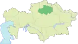 | |
| Major cities | ||
| Authority control |
|---|