Hattian Bala District
The Hattian Bala District (Urdu: ضلع ہٹیاں بالا) is one of the ten districts of Pakistan's dependent territory of Azad Kashmir. The district's headquarters is the town of Hattian Bala. Prior to 2009, the Hattian Bala District was a tehsil of the Muzaffarabad District.
Hattian Bala District
ضلع ہٹیاں بالا | |
|---|---|
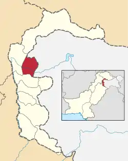 Map of Azad Kashmir with the Hattian Bala District highlighted in red | |
| Sovereign state | |
| Dependent territory | |
| Division | Muzaffarabad Division |
| Headquarters | Hattian Bala |
| Area | |
| • Land | 854 km2 (330 sq mi) |
| Population (2017) | |
| • Total | 230,529 |
| • Density | 270/km2 (700/sq mi) |
| Number of tehsils | 3 |
History
Before the establishment of Azad Kashmir in 1947, what is now the Hattian Bala District was the part of the Uri Tehsil of the Baramulla District in Jammu and Kashmir. Following the ceasefire of the first war between India and Pakistan, Hattian Bala became part of the Muzaffarabad District and remained so until 2009. During Pakistan's coalition government of Sardar Muhammad Yaqoob Khan, Hattian Bala was made a district in July 2009.
Geography
The Hattian Bala District is bounded on the north and east by the Kupwara District and the Baramulla District of Indian-administered Jammu and Kashmir, on the south by the Bagh District, and on the west by the Muzaffarabad District. The Hattian Bala District has a population of 230,529.[1]
Economy
The rural urban ratio is 90:10. The majority of the rural population depend on agriculture, livestock, and forestry for subsistence. Many people work or are settled abroad in the Middle East, the United Kingdom, and the United States, and they support their families who they have left behind. The Hattian Bala District is primarily a hilly and mountainous region with stretches of plains along the Jehlum River, which enters the district at the LOC point at Chakothi and continues northwest through the Jehlum Valley. Due to its fast-flowing rivers, the Hattian Bala District has great hydroelectric potential. Hydroelectric power stations are located at Kathai, Leepa, and Sharian. The district's natural environment includes the valleys of Leepa, Khalana Chham, Ghail, Saina Daman Chamm, Dhani Shahdarrah, Charoi, Chinari, Jaskool, Chonoian, Bharyan (Lower Chonoian), and Chakar Salmia.
Languages
Languages spoken in the Hattian Bala District are Urdu, Pahari (with a slight dialectal difference due to heavy Kashmiri influence), Gojri, and Kashmiri.
Administrative divisions
The Hattian Bala District consists of three tehsils:[2]
- Chikkar Tehsil
- Hattian Bala Tehsil
- Leepa Tehsil
The district council of Hattian Bala has 12 union councils (consisting of eight UCs from Constituency No. 5 and four UCs from Constituency No. 6), one municipal committee at Hattian, and one town committee at Chikar. The rural development department has three centers: Hattian, Leepa, and Chikar. The Assistant Director of LG&RDD Hattian is the administrative officer for rural development, with two project managers at each center.
Education
According to the Alif Ailaan Pakistan District Education Rankings 2015, the Hattian Bala District is ranked 28 out of 148 districts in terms of education. For facilities and infrastructure, the district is ranked 112 out of 148.[3] The district has few colleges, so many people in the district attend the Allama Iqbal Open University or the AJK University at its main Muzaffarabad campus, at its Neelum campus, or at the recently inaugurated Hattian Bala campus, which has faculties for the teaching of the English Language, computer science, and business administration. Two areas in the district are renowned for education, having high literacy rates: Leepa Valley and the village of Pahal, located near the LOC. The district also has some private institutions, such as the READ Foundation Science College Hattian Bala, the READ Foundation Science College Chenari, and the Smart School Hattian Bala.
References
- "Census 2017: AJK population rises to over 4m". The Nation. Retrieved 2017-09-01.
- "Tehsils of Hattian Bala District on AJK map". ajk.gov.pk. AJK Official Portal. Retrieved 19 November 2019.
- "Individual district profile link, 2015". Alif Ailaan. Archived from the original on 2016-03-04. Retrieved 2015-05-06.
Provincial capital: Muzaffarabad | ||
| Muzaffarabad | 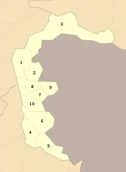 | |
| Poonch | ||
| Mirpur | ||