Kunčice pod Ondřejníkem
Kunčice pod Ondřejníkem is a municipality and village in Frýdek-Místek District in the Moravian-Silesian Region of the Czech Republic. It has about 2,400 inhabitants. It lies in the Moravian-Silesian Beskids and is a popular spot for tourists.
Kunčice pod Ondřejníkem | |
|---|---|
 Kunčice pod Ondřejníkem under the Skalka hill | |
 Flag  Coat of arms | |
 Kunčice pod Ondřejníkem Location in the Czech Republic | |
| Coordinates: 49°33′2″N 18°15′40″E | |
| Country | |
| Region | Moravian-Silesian |
| District | Frýdek-Místek |
| First mentioned | 14th century |
| Area | |
| • Total | 20.19 km2 (7.80 sq mi) |
| Elevation | 395 m (1,296 ft) |
| Population (2020-01-01[1]) | |
| • Total | 2,373 |
| • Density | 120/km2 (300/sq mi) |
| Time zone | UTC+1 (CET) |
| • Summer (DST) | UTC+2 (CEST) |
| Postal code | 739 13 |
| Website | www |
Sights
There is an 18th-century wooden church in the municipality. It was relocated here from the Subcarpathian Rus in 1931.
Gallery
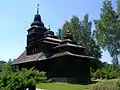 Church of Saints Procopius and Barbara
 Church of Saint Mary Magdalene
 Train station
References
- "Population of Municipalities – 1 January 2020". Czech Statistical Office. 2020-04-30.
External links
| Wikimedia Commons has media related to Kunčice pod Ondřejníkem. |
- (in Czech) Official website
| Authority control |
|
|---|
This article is issued from Wikipedia. The text is licensed under Creative Commons - Attribution - Sharealike. Additional terms may apply for the media files.