Návsí
![]() Návsí (Polish:
Návsí (Polish: ![]() Nawsie, German: Nawsy) is a municipality and village in Frýdek-Místek District in the Moravian-Silesian Region of the Czech Republic. It has about 3,900 inhabitants. Polish minority makes up 19.1% of the population.[2]
Nawsie, German: Nawsy) is a municipality and village in Frýdek-Místek District in the Moravian-Silesian Region of the Czech Republic. It has about 3,900 inhabitants. Polish minority makes up 19.1% of the population.[2]
Návsí
Nawsie | |
|---|---|
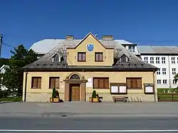 Municipal office | |
 Flag  Coat of arms | |
 Návsí Location in the Czech Republic | |
| Coordinates: 49°35′14″N 18°45′33″E | |
| Country | |
| Region | Moravian-Silesian |
| District | Frýdek-Místek |
| First mentioned | 1435 |
| Government | |
| • Mayor | Lenka Husarová |
| Area | |
| • Total | 19.63 km2 (7.58 sq mi) |
| Elevation | 386 m (1,266 ft) |
| Population (2020-01-01[1]) | |
| • Total | 3,865 |
| • Density | 200/km2 (510/sq mi) |
| Time zone | UTC+1 (CET) |
| • Summer (DST) | UTC+2 (CEST) |
| Postal code | 739 91, 739 92 |
| Website | www |
Etymology
The name is of cultural origins, nawsie denotes an empty part of a village customarily used as a common pasture.[3]
Geography
Návsí lies in the historical region of Cieszyn Silesia, on the both banks of the Olza River, between Silesian and Moravian-Silesian Beskids mountain ranges. Mountain meadow of Filipka, which is a nature monument, lies on the north of the municipality. It offers great view of the Olza River valley and peaks of Moravian-Silesian Beskids.
History
It is possible that the village was already first mentioned in a document of Bishop of Wrocław issued on 23 May 1223 for Norbertine Sisters in Rybnik among villages paying them a tithe, as Novoza, however without certainty.[4][5]
Nawsie was originally a part of Old Jabłonków, but nearby a new settlement emerged (Jabłonków) and Nawsie became a separate village. Under the modern name the village was first mentioned as Nawsy in a written document in 1577.[3] In 1435 Wacław I, Duke of Cieszyn gave a privilege to Paweł Sikora to establish a farming community. Návsí lies on the old trade route going from today's Slovakia to Cieszyn, thus offering good trading opportunities. Craftsmen began to settle in the village. However, village's location had also negative consequences, frequent marches of various armies and frequent Olza floodings caused that in the second half of the 17th century almost one third inhabitants left the village. Sikora family managed the village to 19th century. In 1791 a wooden Protestant church was built, bricked one in 1820. Village developed quickly after 1871 construction of Kassa-Oderberg railway line which runs through the village. Large railway station was built here.
After Revolutions of 1848 in the Austrian Empire a modern municipal division was introduced in the re-established Austrian Silesia. The village as a municipality was subscribed to the political district of Teschen and the legal district of Jablunkau. According to the censuses conducted in 1880, 1890, 1900 and 1910 the population of the municipality grew from 1,412 in 1880 to 2,249 in 1910 with a majority being native Polish-speakers (between 94.7% and 97.7%) accompanied by German-speaking (at most 74 or 4% in 1900) and Czech-speaking people (at most 17 or 0.9% in 1900). In terms of religion in 1910 the majority were Protestants (1,449 or 64.4%), followed by Roman Catholics (783 or 34.8%) and Jews (17 or 0.8%).[6][7]
In 1914 Polish Marshall Józef Piłsudski spent with his legions his first World War I Christmas Eve at the parish of local Protestant church.[8]
After World War I, fall of Austria-Hungary, Polish–Czechoslovak War and the division of Cieszyn Silesia in 1920, it became a part of Czechoslovakia. Following the Munich Agreement, in October 1938 together with the Zaolzie region it was annexed by Poland, administratively adjoined to Cieszyn County of Silesian Voivodeship.[9] Návsí was then annexed by Nazi Germany at the beginning of World War II. After the war it was restored to Czechoslovakia.
From 1960 to 1994 Návsí was administratively a part of Jablunkov.
Notable people
- Władysław Michejda (1876–1937), Polish lawyer and mayor of Cieszyn
- Tadeusz Michejda (1879–1956), Polish physician and politician
- Władysław Młynek (1930–1997), Polish poet and writer
- Adam Gawlas (born 2002), darts player
Gallery
 Polish primary school
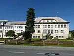 Czech primary school
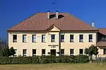
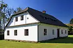 Former Evangelical School Emaus
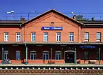 Train station
 Lutheran church
References
- "Population of Municipalities – 1 January 2020". Czech Statistical Office. 2020-04-30.
- "Public database: Census 2011". Czech Statistical Office. Retrieved 2020-10-18.
- Mrózek, Robert (1984). Nazwy miejscowe dawnego Śląska Cieszyńskiego [Local names of former Cieszyn Silesia] (in Polish). Katowice: University of Silesia in Katowice. pp. 123–124. ISSN 0208-6336.
- Panic, Idzi (2000). "Z badań nad osadami zanikłymi na Górnym Śląsku w średniowieczu. Uwagi w sprawie istnienia zaginionych wsi podcieszyńskich, Nageuuzi, Suenschizi, suburbium, Radouiza, Zasere, Clechemuje oraz Novosa". Pamiętnik Cieszyński. Polskie Towarzystwo Historyczne Oddział w Cieszynie (15): 29–37. ISSN 0137-558X. Retrieved 7 December 2012.
- Panic, Idzi (2010). Śląsk Cieszyński w średniowieczu (do 1528) [Cieszyn Silesia in Middle Ages (until 1528)] (in Polish). Cieszyn: Starostwo Powiatowe w Cieszynie. p. 294. ISBN 978-83-926929-3-5.
- Piątkowski, Kazimierz (1918). Stosunki narodowościowe w Księstwie Cieszyńskiem (in Polish). Cieszyn: Macierz Szkolna Księstwa Cieszyńskiego. pp. 267, 285.
- Ludwig Patryn (ed): Die Ergebnisse der Volkszählung vom 31. Dezember 1910 in Schlesien, Troppau 1912.
- Nowak 2008, 16.
- "Ustawa z dnia 27 października 1938 r. o podziale administracyjnym i tymczasowej organizacji administracji na obszarze Ziem Odzyskanych Śląska Cieszyńskiego". Dziennik Ustaw Śląskich (in Polish). Katowice. nr 18/1938, poz. 35. 31 October 1938. Retrieved 1 July 2014.
- Cicha, Irena; Jaworski, Kazimierz; Ondraszek, Bronisław; Stalmach, Barbara; Stalmach, Jan (2000). Olza od pramene po ujście. Český Těšín: Region Silesia. ISBN 80-238-6081-X.
- Nowak, Krzysztof (2008). "Polskość i ruch narodowy". In Krzysztof Nowak (ed.). Pierwsza Niepodległość. Cieszyn: Urząd Miejski Cieszyn. pp. 7–17. ISBN 978-83-89835-40-6.
External links
| Wikimedia Commons has media related to Návsí. |
- (in Czech) Official website
- (in Polish) MK PZKO Nawsie


| Authority control |
|---|