Jablunkov
Jablunkov (Czech pronunciation: [ˈjabluŋkof] (![]() listen); Polish:
listen); Polish: ![]() Jabłonków, German: Jablunkau) is a town in Frýdek-Místek District in the Moravian-Silesian Region of the Czech Republic. It has about 5,500 inhabitants. Polish minority makes up 15.7% of the population.[2]
Jabłonków, German: Jablunkau) is a town in Frýdek-Místek District in the Moravian-Silesian Region of the Czech Republic. It has about 5,500 inhabitants. Polish minority makes up 15.7% of the population.[2]
Jablunkov
Jabłonków | |
|---|---|
Town | |
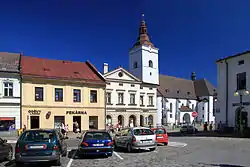 Town square with Corpus Christi Church | |
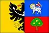 Flag 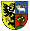 Coat of arms | |
 Jablunkov Location in the Czech Republic | |
| Coordinates: 49°34′28″N 18°45′58″E | |
| Country | |
| Region | Moravian-Silesian |
| District | Frýdek-Místek |
| First mentioned | 1435 |
| Town rights | 1560 |
| Government | |
| • Mayor | Jiří Hamrozi |
| Area | |
| • Total | 10.39 km2 (4.01 sq mi) |
| Elevation | 386 m (1,266 ft) |
| Population (2020-01-01[1]) | |
| • Total | 5,474 |
| • Density | 530/km2 (1,400/sq mi) |
| Time zone | UTC+1 (CET) |
| • Summer (DST) | UTC+2 (CEST) |
| Postal code | 739 91 |
| Website | www |
Geography
Jablunkov lies between the Silesian and Moravian-Silesian Beskids mountain ranges, in the historical region of Cieszyn Silesia, and is the easternmost town of the country. The Lomná River flows into the Olza River in the town.
History
According to historians, the beginnings of Jablunkov are to be found in the place where the present-day village of Hrádek is located. It was first mentioned in a written document in 1435. This settlement was primordially named Jablonka and as such it was mentioned as a seat of a Catholic parish in the register of Peter's Pence payment from 1447 among 50 parishes of Teschen deanery.[3] In the same year Magyars completely destroyed the settlement. Politically it belonged to the Duchy of Teschen, a fee of the Kingdom of Bohemia which was since 1526 a part of the Habsburg Monarchy. In 1560 Wenceslaus III Adam, Duke of Cieszyn, granted town rights to the town. It continuously developed and by the end of the 16th century it had a mayor and a town council.
The town profited from its location in the Jablunkov Pass. It was located on an ancient trade route going from the Mediterranean Sea to the Baltic Sea. The route was used by merchants of ancient Rome; frequent discoveries of Roman coins confirm that. Important trading routes to Kraków (north) and to Upper Hungary (east) also run through the town. It became more and more important and also rich, as many citizens lived by trading. In the middle of the 17th century it had 750 inhabitants, together with a suburb and a village of Písečná. In the 18th century most of citizens worked in trade, craftsmanship and farming. At the end of the 19th century, many new buildings were built. A new Art Nouveau town hall was built in 1905.
After Revolutions of 1848 in the Austrian Empire a modern municipal division was introduced in the re-established Austrian Silesia. The town became a seat of a legal district in the political district of Cieszyn. According to the censuses conducted in 1880, 1890, 1900 and 1910 the population of the municipality grew from 2,941 in 1880 to 3,289 in 1910 with the majority being native Polish-speakers (dropping from 89.4% in 1880 to 84.4% in 1910) accompanied by German-speaking minority (growing from 9.2% in 1880 to 14.1% in 1910) and Czech-speaking people (at most 57 or 1.5% in 1910). In terms of religion in 1910 the majority were Roman Catholics (88.5%), followed by Protestants (9.2%), Jews (90 or 2.3%) and 2 people adhering to another faiths.[4] The town was also traditionally inhabited by a specific ethnographic group called Jacki, speaking Jablunkov dialect.
After World War I, fall of Austria-Hungary, Polish–Czechoslovak War and the division of Cieszyn Silesia in 1920, it became a part of Czechoslovakia. Following the Munich Agreement, in October 1938 together with the Zaolzie region it was annexed by Poland, administratively adjoined to Cieszyn County of Silesian Voivodeship.[5] It was then annexed by Nazi Germany at the beginning of World War II. After the war it was restored to Czechoslovakia.
Landmarks
The most important landmarks are the historic town square with a fountain and statue of the Virgin Mary from 1655, the Roman Catholic church built in 1620, and the Elizabethan Monastery. The latter was established by the priest Wawrzyniec Piontek, who wanted to improve medical treatment in the town: the nearest hospital was located in Ostrava. The Elizabethan hospital was built in 1856. It was located near the Olza River and was frequently flooded. A decision was taken to build a new one, which began operating in 1932. In 1948 the monastery and its properties were seized by the Communists, who forbade the further induction of new sisters. Former Elizabethan sisters were ordered to work in a state farm with cattle. In 1989, after the fall of communism, it was returned to the Elizabethan sisters. The monastery in Jablunkov is one of only three Elizabethan monasteries in the Czech Republic, the other two being in Prague and Brno.
There is also a sanatorium in Jablunkov. It was built in 1933–1935 and is a valuable landmark of modern architecture. It is surrounded by a park planted in 1936–1938. There are more than 500 species of trees and shrubs in the park. Several sculptures are also located in the park.
Culture
The most popular cultural event is the annual Gorolski Święto (literally Gorals Festival), organized every year in August since 1948 by the Polish Cultural and Educational Union (PZKO). It is a showcase of local Polish folklore and traditions that attracts visitors from all of Zaolzie and also from foreign countries.
Notable people
- Oskar Zawisza (1878–1933), Polish priest and composer
- Rudolf Paszek (1894–1969), Polish teacher and politician
- Jiří Drahoš (born 1949), physical chemist and politician, President candidate in the 2018 election
Twin towns – sister cities
Jablunkov is twinned with:[6][7]
 Gogolin, Poland
 Kysucké Nové Mesto, Slovakia
- Siemianowice Śląskie, Poland
 Tiachiv, Ukraine
Gallery
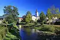 River Lomná
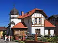 Archive of Cieszyn Silesia Military History
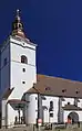 Corpus Christi Church
.jpg.webp) Fountain with statue of the Immaculata (Blessed Virgin Mary)
Fountain with statue of the Immaculata (Blessed Virgin Mary)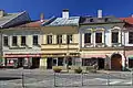 Tenement houses on Mariánské square
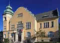 Town hall
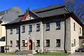 House of children and youth, former town hall
References
- "Population of Municipalities – 1 January 2020". Czech Statistical Office. 2020-04-30.
- "Public database: Census 2011". Czech Statistical Office. Retrieved 2020-11-25.
- "Registrum denarii sancti Petri in archidiaconatu Opoliensi sub anno domini MCCCCXLVII per dominum Nicolaum Wolff decretorum doctorem, archidiaconum Opoliensem, ex commissione reverendi in Christo patris ac domini Conradi episcopi Wratislaviensis, sedis apostolice collectoris, collecti". Zeitschrift des Vereins für Geschichte und Alterthum Schlesiens (in German). Breslau: H. Markgraf. 27: 361–372. 1893. Retrieved 21 July 2014.
- Piątkowski, Kazimierz (1918). Stosunki narodowościowe w Księstwie Cieszyńskiem (in Polish). Cieszyn: Macierz Szkolna Księstwa Cieszyńskiego. pp. 266, 284.
- "Ustawa z dnia 27 października 1938 r. o podziale administracyjnym i tymczasowej organizacji administracji na obszarze Ziem Odzyskanych Śląska Cieszyńskiego". Dziennik Ustaw Śląskich (in Polish). Katowice. nr 18/1938, poz. 35. 31 October 1938. Retrieved 1 July 2014.
- "Partnerská města Jablunkova". jablunkov.cz (in Czech). Město Jablunkov. Retrieved 2020-09-22.
- "Jablunkov a Tjačiv se oficiálně stali partnery". parlamentnilisty.cz (in Czech). Parlamentní listy. 2017-05-29. Retrieved 2020-09-22.
Bibliography
External links
| Wikimedia Commons has media related to Jablunkov. |
- (in Czech) Official website

| Authority control |
|
|---|