Hrádek (Frýdek-Místek District)
![]() Hrádek (Polish:
Hrádek (Polish: ![]() Gródek, German: Grudek) is a municipality and village in Frýdek-Místek District in the Moravian-Silesian Region of the Czech Republic. It has about 1,900 inhabitants. Polish minority makes up 31.3% of the population.[2]
Gródek, German: Grudek) is a municipality and village in Frýdek-Místek District in the Moravian-Silesian Region of the Czech Republic. It has about 1,900 inhabitants. Polish minority makes up 31.3% of the population.[2]
Hrádek
Gródek | |
|---|---|
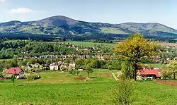 General view of Hrádek | |
.svg.png.webp) Flag  Coat of arms | |
 Hrádek Location in the Czech Republic | |
| Coordinates: 49°37′0″N 18°44′14″E | |
| Country | |
| Region | Moravian-Silesian |
| District | Frýdek-Místek |
| First mentioned | 1577 |
| Government | |
| • Mayor | Robert Borski |
| Area | |
| • Total | 9.77 km2 (3.77 sq mi) |
| Elevation | 353 m (1,158 ft) |
| Population (2020-01-01[1]) | |
| • Total | 1,879 |
| • Density | 190/km2 (500/sq mi) |
| Time zone | UTC+1 (CET) |
| • Summer (DST) | UTC+2 (CEST) |
| Postal code | 739 97 |
| Website | www |
Etymology
The name of the municipality is a diminutive form of the word gord (Czech: Hradiště, Polish: Gród).
Geography
Hrádek lies on the Olza River. The municipality lies between the mountain ranges of the Silesian Beskids and the Moravian-Silesian Beskids, in the historical region of Cieszyn Silesia.
History
The beginnings of Hrádek can be traced back to the 12th century, when a small fort was built on a trade route running through the Jablunkov Pass. A settlement grew up around the fort. The small fort and its neighboring settlement were completely destroyed by the Magyars in 1447. Hrádek was first mentioned in a written document in 1577 as Grudek.[3] It belonged then to the Duchy of Teschen, a fee of the Kingdom of Bohemia and a part of the Habsburg Monarchy.
Hrádek began to develop more briskly at the end of the 18th century, when about 900 people working mainly in agriculture lived there. After 1880 sandstone was exploited; its exploitation lasted until the outbreak of World War I.
After Revolutions of 1848 in the Austrian Empire a modern municipal division was introduced in the re-established Austrian Silesia. The village as a municipality was subscribed to the political district of Cieszyn and the legal district of Jablunkov. According to the censuses conducted in 1880, 1890, 1900 and 1910 the population of the municipality grew from 798 in 1880 to 886 in 1910 with the majority being native Polish-speakers (between 98.1% and 100%) accompanied by Czech-speaking (at most 6 or 0.7% in 1910) and German-speaking people (at most 5 or 0.6% in 1910) and in 1910 by 5 people speaking other languages. In terms of religion in 1910 the majority were Protestants (74.9%), followed by Roman Catholics (24.9%) and Jews (2 people).[4][5] Hrádek was also traditionally inhabited by Cieszyn Vlachs, speaking Cieszyn Silesian dialect.
After World War I, fall of Austria-Hungary, Polish–Czechoslovak War and the division of Cieszyn Silesia in 1920, it became a part of Czechoslovakia. Following the Munich Agreement, in October 1938 together with the Zaolzie region it was annexed by Poland, administratively adjoined to Cieszyn County of Silesian Voivodeship.[6] It was then annexed by Nazi Germany at the beginning of World War II. After the war it was restored to Czechoslovakia.
From 1980 to 1990 the village was an administrative part of Jablunkov.
Bełko Rock legend
There is a legend connected with the ancient fort. Notable local landmark Bełko Rock is supposed to be the place of death of the infamous legendary knight Bełko, who plundered merchants and murdered people. According to one version, he committed suicide when his conscience overwhelmed him; according to the second version, he fell down with his horse into the Olza chasing a mirage of victims of his cruelty.
Notable people
- Władysław Młynek (1930–1997), Polish poet and writer
Gallery
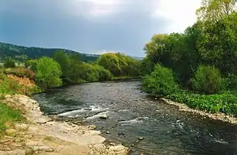 Olza River in the municipality
 Bełko Rock
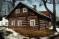 Old wooden house
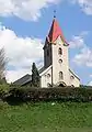 Lutheran Church
References
- "Population of Municipalities – 1 January 2020". Czech Statistical Office. 2020-04-30.
- "Public database: Census 2011". Czech Statistical Office. Retrieved 2020-11-04.
- Mrózek, Robert (1984). Nazwy miejscowe dawnego Śląska Cieszyńskiego [Local names of former Cieszyn Silesia] (in Polish). Katowice: University of Silesia in Katowice. p. 74. ISSN 0208-6336.
- Piątkowski, Kazimierz (1918). Stosunki narodowościowe w Księstwie Cieszyńskiem (in Polish). Cieszyn: Macierz Szkolna Księstwa Cieszyńskiego. pp. 266, 284.
- Ludwig Patryn (ed): Die Ergebnisse der Volkszählung vom 31. Dezember 1910 in Schlesien, Troppau 1912.
- "Ustawa z dnia 27 października 1938 r. o podziale administracyjnym i tymczasowej organizacji administracji na obszarze Ziem Odzyskanych Śląska Cieszyńskiego". Dziennik Ustaw Śląskich (in Polish). Katowice. nr 18/1938, poz. 35. 31 October 1938. Retrieved 1 July 2014.
- "Partnerství". obechradek.cz (in Czech). Obec Hrádek. Retrieved 2020-11-04.
- Cicha, Irena; Jaworski, Kazimierz; Ondraszek, Bronisław; Stalmach, Barbara; Stalmach, Jan (2000). Olza od pramene po ujście. Český Těšín: Region Silesia. ISBN 80-238-6081-X.
External links
| Wikimedia Commons has media related to Hrádek (Frýdek-Místek District). |
- (in Czech) Official website

| Authority control |
|
|---|