Janovice
Janovice (Polish: Janowice) is a municipality and village in Frýdek-Místek District in the Moravian-Silesian Region of the Czech Republic. It has about 1,900 inhabitants. It situated in the foothills of the Moravian-Silesian Beskids mountain range, 6 km south-east from Frýdek-Místek.
Janovice | |
|---|---|
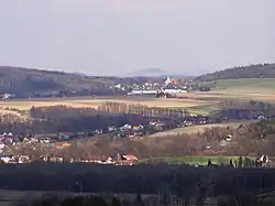 General view of Janovice | |
 Flag  Coat of arms | |
 Janovice Location in the Czech Republic | |
| Coordinates: 49°37′17″N 18°24′22″E | |
| Country | |
| Region | Moravian-Silesian |
| District | Frýdek-Místek |
| First mentioned | 1447 |
| Government | |
| • Mayor | Svatopluk Běrský |
| Area | |
| • Total | 13.16 km2 (5.08 sq mi) |
| Elevation | 364 m (1,194 ft) |
| Population (2020-01-01[1]) | |
| • Total | 1,930 |
| • Density | 150/km2 (380/sq mi) |
| Time zone | UTC+1 (CET) |
| • Summer (DST) | UTC+2 (CEST) |
| Postal code | 739 02, 739 11 |
| Website | www |
Thanks to the geographical location of the municipality among the nearby industrial region of Ostrava and the traditional agricultural area of the Beskids, Janovice can be called "the gate to the Beskids". The municipality lies in the historical region of Cieszyn Silesia.
History
It is not certain when Janovice had been established. It could have been first mentioned in a Latin document of Diocese of Wrocław called Liber fundationis episcopatus Vratislaviensis from around 1305 as item in Jannutha,[2][3][4] however it is more likely that Jannutha was in fact Jamnicze, the town predating a nearby Frýdek. Surely it was later mentioned in 1450 as Janowicze.[5]
Politically Janovice belonged initially to the Duchy of Teschen, formed in 1290 in the process of feudal fragmentation of Poland and was ruled by a local branch of Piast dynasty. In 1327 the duchy became a fee of Kingdom of Bohemia, which after 1526 became part of the Habsburg Monarchy. In 1573 it was sold as one of 16 villages and the town of Friedeck and formed a state country split from the Duchy of Teschen.[6]
After World War I and fall of Austria-Hungary it became a part of Czechoslovakia. In March 1939 it became a part of Protectorate of Bohemia and Moravia. After World War II it was restored to Czechoslovakia.
References
- "Population of Municipalities – 1 January 2020". Czech Statistical Office. 2020-04-30.
- Panic, Idzi (2010). Śląsk Cieszyński w średniowieczu (do 1528) [Cieszyn Silesia in Middle Ages (until 1528)] (in Polish). Cieszyn: Starostwo Powiatowe w Cieszynie. pp. 297–299. ISBN 978-83-926929-3-5.
- Schulte, Wilhelm (1889). Codex Diplomaticus Silesiae T.14 Liber Fundationis Episcopatus Vratislaviensis (in German). Breslau.
- "Liber fundationis episcopatus Vratislaviensis" (in Latin). Retrieved 13 July 2014.
- Mrózek, Robert (1984). Nazwy miejscowe dawnego Śląska Cieszyńskiego [Local names of former Cieszyn Silesia] (in Polish). Katowice: University of Silesia in Katowice. p. 80. ISSN 0208-6336.
- Panic, Idzi (2011). Śląsk Cieszyński w początkach czasów nowożytnych (1528-1653) [Cieszyn Silesia in the beginnings of Modern Era (1528-1653)] (in Polish). Cieszyn: Starostwo Powiatowe w Cieszynie. p. 224. ISBN 978-83-926929-5-9.
External links
- (in Czech) Official website

| Authority control |
|
|---|
