Písek (Frýdek-Místek District)
![]() Písek (Polish:
Písek (Polish: ![]() Piosek, German: Piosek) is a municipality and village in Frýdek-Místek District in the Moravian-Silesian Region of the Czech Republic. It has about 1,900 inhabitants. Polish minority makes up 16.4% of the population.[2]
Piosek, German: Piosek) is a municipality and village in Frýdek-Místek District in the Moravian-Silesian Region of the Czech Republic. It has about 1,900 inhabitants. Polish minority makes up 16.4% of the population.[2]
Písek
Piosek | |
|---|---|
 Elementary school and kindergarten | |
_vlajka.jpg.webp) Flag  Coat of arms | |
 Písek Location in the Czech Republic | |
| Coordinates: 49°33′33″N 18°48′8″E | |
| Country | |
| Region | Moravian-Silesian |
| District | Frýdek-Místek |
| First mentioned | 1466 |
| Government | |
| • Mayor | Věra Szkanderová |
| Area | |
| • Total | 15.46 km2 (5.97 sq mi) |
| Elevation | 386 m (1,266 ft) |
| Population (2020-01-01[1]) | |
| • Total | 1,863 |
| • Density | 120/km2 (310/sq mi) |
| Time zone | UTC+1 (CET) |
| • Summer (DST) | UTC+2 (CEST) |
| Postal code | 739 84 |
| Website | www |
Etymology
The name of the municipality is of topographic origins and literally means "sand". Historically it has been scribed as Piesek (1523), Pisek (1577, 1621), Pyßek/Pioßek (1643), Piasek (1652) and so on.[3]
Geography
Písek lies in the Silesian Beskids mountain range, in the historical region of Cieszyn Silesia. Olza River flows through the municipality. A road linking the Polish village of Istebna with Jablunkov runs through the municipality.
History
Písek was established most probably in the 14th century. Historians presume that on the basis of establishment date of nearby Bukowiec (1353). The village was first attested in a written document in 1466 where a local vogt was mentioned as foytowi Piseczkemu.[4][5] Politically Písek belonged initially to the Duchy of Teschen, a fee of the Kingdom of Bohemia, which after 1526 became part of the Habsburg Monarchy.
In the 14th and 15th centuries villagers lived mainly off simple farming, pastures and forest work. As a result of Thirty Years' War number of farms, farmers, millers etc. dropped. After the establishment of Třinec Iron and Steel Works in 1839 many inhabitants of Písek went there to work as a workers.
After Revolutions of 1848 in the Austrian Empire a modern municipal division was introduced in the re-established Austrian Silesia. The village as a municipality was subscribed to the political district of Teschen and the legal district of Jablunkau. According to the censuses conducted in 1880, 1890, 1900 and 1910 the population of the municipality grew from 884 in 1880 to 1,055 in 1910 with a majority being native Polish-speakers (dropping from 100% in 1880 to 97.5% in 1910) accompanied by German-speaking (at most 26 or 2.5% in 1910) and Czech-speaking people (at most 21 or 1.1% in 1910). In terms of religion in 1910 the majority were Roman Catholics (59.5%), followed by Protestants (40.5%).[6] Písek was also traditionally inhabited by Silesian Gorals, speaking Jablunkov dialect.
After World War I, fall of Austria-Hungary, Polish–Czechoslovak War and the division of Cieszyn Silesia in 1920, it became a part of Czechoslovakia. Following the Munich Agreement, in October 1938 together with the Zaolzie region it was annexed by Poland, administratively adjoined to Cieszyn County of Silesian Voivodeship.[7] It was then annexed by Nazi Germany at the beginning of World War II. After the war it was restored to Czechoslovakia.
From 1975 to 1990 the village was an administrative part of Jablunkov.
Religion
The majority of population are religious, most of which are Roman Catholics. There is a Catholic church in the municipality and a SCEAV Lutheran church consecrated in 2010.
Gallery
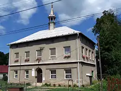
 Municipal office
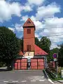 Fire station
 Old wooden house
References
- "Population of Municipalities – 1 January 2020". Czech Statistical Office. 2020-04-30.
- "Public database: Census 2011". Czech Statistical Office. Retrieved 2020-11-04.
- Mrózek, Robert (1984). Nazwy miejscowe dawnego Śląska Cieszyńskiego [Local names of former Cieszyn Silesia] (in Polish). Katowice: University of Silesia in Katowice. pp. 127–128. ISSN 0208-6336.
- Mrózek, Robert (1984). Nazwy miejscowe dawnego Śląska Cieszyńskiego [Local names of former Cieszyn Silesia] (in Polish). Katowice: University of Silesia in Katowice. p. 138. ISSN 0208-6336.
- Panic, Idzi (2010). Śląsk Cieszyński w średniowieczu (do 1528) [Cieszyn Silesia in Middle Ages (until 1528)] (in Polish). Cieszyn: Starostwo Powiatowe w Cieszynie. p. 313. ISBN 978-83-926929-3-5.
- Piątkowski, Kazimierz (1918). Stosunki narodowościowe w Księstwie Cieszyńskiem (in Polish). Cieszyn: Macierz Szkolna Księstwa Cieszyńskiego. pp. 267, 285.
- "Ustawa z dnia 27 października 1938 r. o podziale administracyjnym i tymczasowej organizacji administracji na obszarze Ziem Odzyskanych Śląska Cieszyńskiego". Dziennik Ustaw Śląskich (in Polish). Katowice. nr 18/1938, poz. 35. 31 October 1938. Retrieved 1 July 2014.
- Cicha, Irena; Jaworski, Kazimierz; Ondraszek, Bronisław; Stalmach, Barbara; Stalmach, Jan (2000). Olza od pramene po ujście. Český Těšín: Region Silesia. ISBN 80-238-6081-X.
External links
| Wikimedia Commons has media related to Písek (Frýdek-Místek District). |
- (in Czech) Official website

| Authority control |
|
|---|