Saint-Héand
Saint-Héand is a commune in the Loire department in central France, 12 kilometres from Saint-Étienne.
Saint-Héand | |
|---|---|
Commune | |
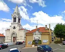 Church and town hall | |
.svg.png.webp) Coat of arms | |
Location of Saint-Héand 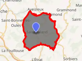
| |
 Saint-Héand  Saint-Héand | |
| Coordinates: 45°31′46″N 4°22′25″E | |
| Country | France |
| Region | Auvergne-Rhône-Alpes |
| Department | Loire |
| Arrondissement | Saint-Étienne |
| Canton | Sorbiers |
| Intercommunality | Saint-Étienne Métropole |
| Government | |
| • Mayor (2014–2020) | Jean-Marc Thélisson |
| Area 1 | 31.3 km2 (12.1 sq mi) |
| Population (2017-01-01)[1] | 3,592 |
| • Density | 110/km2 (300/sq mi) |
| Time zone | UTC+01:00 (CET) |
| • Summer (DST) | UTC+02:00 (CEST) |
| INSEE/Postal code | 42234 /42570 |
| Elevation | 467–870 m (1,532–2,854 ft) (avg. 680 m or 2,230 ft) |
| 1 French Land Register data, which excludes lakes, ponds, glaciers > 1 km2 (0.386 sq mi or 247 acres) and river estuaries. | |
The name Héand comes from Latin Eugendus; and was given to the town either by the saint himself when founding a monastery, or by pilgrims bringing relics here.
Population
|
|
See also
References
- "Populations légales 2017". INSEE. Retrieved 6 January 2020.
| Wikimedia Commons has media related to Saint-Héand. |
| Authority control |
|---|
This article is issued from Wikipedia. The text is licensed under Creative Commons - Attribution - Sharealike. Additional terms may apply for the media files.