Lebanon, New Jersey
Lebanon is a borough in Hunterdon County, New Jersey, United States. As of the 2010 United States Census, the borough's population was 1,358,[8][9][10] reflecting an increase of 293 (+27.5%) from the 1,065 counted in the 2000 Census, which had in turn increased by 29 (+2.8%) from the 1,036 counted in the 1990 Census.[19]
Lebanon, New Jersey | |
|---|---|
| Borough of Lebanon | |
 Lebanon Reformed Church | |
 Map of Lebanon in Hunterdon County. Inset: Location of Hunterdon County highlighted in the State of New Jersey. | |
 Census Bureau map of Lebanon, New Jersey | |
 Lebanon Location in Hunterdon County 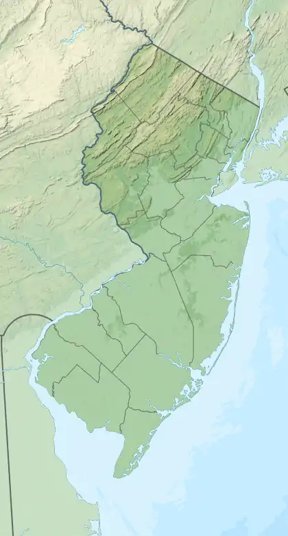 Lebanon Location in New Jersey  Lebanon Location in the United States | |
| Coordinates: 40.641862°N 74.833312°W[1][2] | |
| Country | |
| State | |
| County | |
| Incorporated | April 20, 1926 |
| Government | |
| • Type | Borough |
| • Body | Borough Council |
| • Mayor | James J. Pittinger (R, term ends December 31, 2022)[4][5] |
| • Administrator / Municipal clerk | Karen Romano[6] |
| Area | |
| • Total | 0.90 sq mi (2.34 km2) |
| • Land | 0.90 sq mi (2.34 km2) |
| • Water | 0.00 sq mi (0.00 km2) 0.00% |
| Area rank | 514th of 565 in state 25th of 26 in county[1] |
| Elevation | 246 ft (75 m) |
| Population | |
| • Total | 1,358 |
| • Estimate (2019)[11] | 1,644 |
| • Rank | 522nd of 566 in state 22nd of 26 in county[12] |
| • Density | 1,532.0/sq mi (591.5/km2) |
| • Density rank | 333rd of 566 in state 4th of 26 in county[12] |
| Time zone | UTC−05:00 (Eastern (EST)) |
| • Summer (DST) | UTC−04:00 (Eastern (EDT)) |
| ZIP Code | |
| Area code(s) | 908 Exchange: 236[15] |
| FIPS code | 3401939630[1][16][17] |
| GNIS feature ID | 0885275[1][18] |
| Website | www |
Lebanon was incorporated as a borough by an act of the New Jersey Legislature on March 26, 1926, from portions of Clinton Township, based on the results of a referendum held on April 20, 1926. Additional portions of Clinton Township were annexed in 1962.[20]
The borough is located north of the Round Valley Reservoir. The Borough was known in the early part of the 19th century as Jacksonville and later as Lebanonville, Lebanonville Depot and finally Lebanon, a station on the Central Railroad of New Jersey. The center of Lebanon has changed little in the past century. The Dutch Reformed Church is one of the oldest churches in the County. Records of the church begin in 1769, however, the church is cited as early as 1747.[21] The Lebanon Historic District was listed on the state and national registers of historic places in 2009.
Geography
According to the United States Census Bureau, the borough had a total area of 0.90 square miles (2.34 km2), almost all of which was land.[1][2]
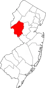
The borough is an independent municipality surrounded by Clinton Township, making it part of one of 21 pairs of "doughnut towns" in the state, where one municipality entirely surrounds another.[22][23][24]
Demographics
| Historical population | |||
|---|---|---|---|
| Census | Pop. | %± | |
| 1930 | 550 | — | |
| 1940 | 638 | 16.0% | |
| 1950 | 752 | 17.9% | |
| 1960 | 880 | 17.0% | |
| 1970 | 885 | 0.6% | |
| 1980 | 820 | −7.3% | |
| 1990 | 1,036 | 26.3% | |
| 2000 | 1,065 | 2.8% | |
| 2010 | 1,358 | 27.5% | |
| 2019 (est.) | 1,644 | [11][25] | 21.1% |
| Population sources: 1930[26] 1930-1990[27] 2000[28][29] 2010[8][9][10] | |||
Census 2010
The 2010 United States Census counted 1,358 people, 602 households, and 366 families in the borough. The population density was 1,532.0 per square mile (591.5/km2). There were 664 housing units at an average density of 749.1 per square mile (289.2/km2). The racial makeup was 90.13% (1,224) White, 1.77% (24) Black or African American, 0.15% (2) Native American, 5.23% (71) Asian, 0.00% (0) Pacific Islander, 0.88% (12) from other races, and 1.84% (25) from two or more races. Hispanic or Latino of any race were 5.01% (68) of the population.[8]
Of the 602 households, 28.6% had children under the age of 18; 46.5% were married couples living together; 10.5% had a female householder with no husband present and 39.2% were non-families. Of all households, 34.2% were made up of individuals and 13.1% had someone living alone who was 65 years of age or older. The average household size was 2.26 and the average family size was 2.93.[8]
21.1% of the population were under the age of 18, 6.4% from 18 to 24, 30.5% from 25 to 44, 28.9% from 45 to 64, and 13.2% who were 65 years of age or older. The median age was 40.2 years. For every 100 females, the population had 84.8 males. For every 100 females ages 18 and older there were 82.6 males.[8] The Census Bureau's 2006-2010 American Community Survey showed that (in 2010 inflation-adjusted dollars) median household income was $71,629 (with a margin of error of +/- $5,410) and the median family income was $96,500 (+/- $10,275). Males had a median income of $70,977 (+/- $9,418) versus $53,750 (+/- $18,758) for females. The per capita income for the borough was $37,035 (+/- $2,975). About 1.5% of families and 2.8% of the population were below the poverty line, including 1.3% of those under age 18 and 1.8% of those age 65 or over.[30]
Census 2000
As of the 2000 United States Census[16] there were 1,065 people, 458 households, and 287 families residing in the borough. The population density was 1,227.3 people per square mile (472.6/km2). There were 477 housing units at an average density of 549.7 per square mile (211.7/km2). The racial makeup of the borough was 95.40% White, 0.66% African American, 0.19% Native American, 3.10% Asian, 0.38% from other races, and 0.28% from two or more races. Hispanic or Latino of any race were 2.07% of the population.[28][29]
There were 458 households, out of which 30.8% had children under the age of 18 living with them, 50.4% were married couples living together, 9.6% had a female householder with no husband present, and 37.3% were non-families. 33.0% of all households were made up of individuals, and 10.5% had someone living alone who was 65 years of age or older. The average household size was 2.33 and the average family size was 2.97.[28][29]
In the borough the population was spread out, with 24.1% under the age of 18, 3.7% from 18 to 24, 35.1% from 25 to 44, 25.4% from 45 to 64, and 11.6% who were 65 years of age or older. The median age was 39 years. For every 100 females, there were 92.2 males. For every 100 females age 18 and over, there were 82.4 males.[28][29]
The median income for a household in the borough was $68,542, and the median income for a family was $83,436. Males had a median income of $52,316 versus $37,396 for females. The per capita income for the borough was $34,066. About 0.7% of families and 3.6% of the population were below the poverty line, including 2.0% of those under age 18 and 5.1% of those age 65 or over.[28][29]
Government
Local government
Lebanon Borough is governed under the Borough form of New Jersey municipal government, one of 218 municipalities (of the 565) statewide that use this form, the most common form of government in New Jersey.[31] The governing body is comprised of the Mayor and the Borough Council, with all positions elected at-large on a partisan basis as part of the November general election. The Mayor is elected directly by the voters to a four-year term of office. The Borough Council is comprised of six members elected to serve three-year terms on a staggered basis, with two seats coming up for election each year in a three-year cycle.[3] The Borough form of government used by Lebanon is a "weak mayor / strong council" government in which council members act as the legislative body with the mayor presiding at meetings and voting only in the event of a tie. The mayor can veto ordinances subject to an override by a two-thirds majority vote of the council. The mayor makes committee and liaison assignments for council members, and most appointments are made by the mayor with the advice and consent of the council.[32][33][34]
As of 2020, the Mayor of Lebanon Borough is Republican James J. Pittinger, whose term of office ends December 31, 2022. The Lebanon Borough Council is comprised of Council President Richard J. Burton (R, 2021), Marlene G. Baldinger (D, 2022), Samuel Berger (R, 2021), Denise Harris (R, 2022), Robert H. Junge (R, 2020), Melissa Saharic (R, 2020; elected to serve an unexpired term).[4][35][36][37][38][39][40]
In August 2019, the Borough Council selected Melissa Saharic to fill the seat expiring in December 2020 that became vacanat following the resignation of Michael Piagentini, who left office the previous month after announcing that he was moving out of the borough.[41] In November 2019, Saharic was elected
After Republican incumbent Barbara "Bonnie" Schmidt and Democratic challenger Marlene Baldinger ended up tied with 431 votes for the second of two council seats in the November 2016 general election, the two faced off in a January runoff, which Baldinger won by a 183-135 margin.[42]
Federal, state and county representation
Lebanon Borough is located in the 7th Congressional District[43] and is part of New Jersey's 23rd state legislative district.[9][44][45]
For the 116th United States Congress. New Jersey's Seventh Congressional District is represented by Tom Malinowski (D, Ringoes).[46] New Jersey is represented in the United States Senate by Democrats Cory Booker (Newark, term ends 2021)[47] and Bob Menendez (Paramus, term ends 2025).[48][49]
For the 2018–2019 session (Senate, General Assembly), the 23rd Legislative District of the New Jersey Legislature is represented in the State Senate by Michael J. Doherty (R, Washington Township, Warren County) and in the General Assembly by John DiMaio (R, Hackettstown) and Erik Peterson (R, Franklin Township, Hunterdon County).[50][51]
Hunterdon County is governed by a five-member Board of Chosen Freeholders, who serve three-year terms of office at-large on a staggered basis, with either one or two seats up for election each year on a partisan basis as part of the November general election. At an annual reorganization meeting held each January, the freeholders select one member to serve as the board's Director and another to serve as Deputy Director.[52] As of 2015, Hunterdon County's Freeholders are Freeholder Director John King (R; Raritan Township, 2015),[53] Freeholder Deputy Director Suzanne Lagay (R; Holland Township, 2016),[54] J. Matthew Holt (R; Clinton Town, 2015),[55] John E. Lanza (R; Flemington, 2016)[56] and Robert G. Walton (R; Hampton, 2017).[57][58] Constitutional officers elected on a countywide basis are County Clerk Mary H. Melfi (R; Flemington, 2017),[59] Sheriff Fredrick W. Brown (R; Alexandria Township, 2016)[60] and Surrogate Susan J. Hoffman (R; Kingwood Township, 2018).[61][62][63]
Politics
As of March 23, 2011, there were a total of 955 registered voters in Lebanon, of which 190 (19.9%) were registered as Democrats, 374 (39.2%) were registered as Republicans and 388 (40.6%) were registered as Unaffiliated. There were three voters registered to other parties.[64]
In the 2012 presidential election, Republican Mitt Romney received 57.5% of the vote (471 cast), ahead of Democrat Barack Obama with 40.9% (335 votes), and other candidates with 1.6% (13 votes), among the 826 ballots cast by the borough's 1,118 registered voters (7 ballots were spoiled), for a turnout of 73.9%.[65][66] In the 2008 presidential election, Republican John McCain received 56.7% of the vote (403 cast), ahead of Democrat Barack Obama with 41.4% (294 votes) and other candidates with 1.3% (9 votes), among the 711 ballots cast by the borough's 861 registered voters, for a turnout of 82.6%.[67] In the 2004 presidential election, Republican George W. Bush received 63.0% of the vote (410 ballots cast), outpolling Democrat John Kerry with 36.1% (235 votes) and other candidates with 0.6% (5 votes), among the 651 ballots cast by the borough's 780 registered voters, for a turnout percentage of 83.5.[68]
In the 2013 gubernatorial election, Republican Chris Christie received 77.1% of the vote (373 cast), ahead of Democrat Barbara Buono with 20.5% (99 votes), and other candidates with 2.5% (12 votes), among the 497 ballots cast by the borough's 1,107 registered voters (13 ballots were spoiled), for a turnout of 44.9%.[69][70] In the 2009 gubernatorial election, Republican Chris Christie received 67.1% of the vote (365 ballots cast), ahead of Democrat Jon Corzine with 19.9% (108 votes), Independent Chris Daggett with 10.1% (55 votes) and other candidates with 1.7% (9 votes), among the 544 ballots cast by the borough's 880 registered voters, yielding a 61.8% turnout.[71]
Historic district
Lebanon Historic District | |
 Italianate style house | |
| Location | Main St., Cherry St., Brunswick Ave., Maple St., High St., Lebanon Borough, New Jersey |
|---|---|
| Area | 91 acres (37 ha) |
| Built by | Oscar Apgar; John C. & Harry Stryker |
| Architectural style | Italianate, Bungalow/craftsman |
| NRHP reference No. | 09000652[72] |
| NJRHP No. | 4475[73] |
| Significant dates | |
| Added to NRHP | August 26, 2009 |
| Designated NJRHP | May 1, 2009 |
The Lebanon Historic District is a historic district encompassing the village of Lebanon. The district was added to the National Register of Historic Places on August 26, 2009, for its significance in architecture and community development from c. 1813 to c. 1942. It includes 227 contributing buildings.[74]
Education
Students in pre-kindergarten through sixth grade for public school are served by the Lebanon Borough School District at Lebanon Borough School.[75][76] As of the 2018–19 school year, the district, comprised of one school, had an enrollment of 40 students and 13.8 classroom teachers (on an FTE basis), for a student–teacher ratio of 2.9:1.[77] In the 2016–17 school year, Lebanon had the 9th-smallest enrollment of any school district in the state, with 101 students.[78]
Students in seventh and eighth grades attend Clinton Township Middle School in Clinton Township[79] as part of a sending/receiving relationship with the Clinton Township School District.[80] As of the 2018–19 school year, the high school had an enrollment of 479 students and 57.0 classroom teachers (on an FTE basis), for a student–teacher ratio of 8.4:1.[81]
Public school students in ninth through twelfth grades attend North Hunterdon High School in Annandale together with students from Bethlehem Township, Clinton Town, Clinton Township, Franklin Township and Union Township.[82][83][84] As of the 2018–19 school year, the high school had an enrollment of 1,584 students and 123.2 classroom teachers (on an FTE basis), for a student–teacher ratio of 12.9:1.[85] The school is part of the North Hunterdon-Voorhees Regional High School District, which also includes students from Califon, Glen Gardner, Hampton, High Bridge, Lebanon Township and Tewksbury Township, who attend Voorhees High School in Lebanon Township.[86][76][87]
Eighth grade students from all of Hunterdon County are eligible to apply to attend the high school programs offered by the Hunterdon County Vocational School District, a county-wide vocational school district that offers career and technical education at its campuses in Raritan Township and at programs sited at local high schools, with no tuition charged to students for attendance.[88]
Emergency services
The Borough of Lebanon is covered by three emergency services providers.[89]
Police and law enforcement is provided by the New Jersey State Police from Troop B, based at the Perryville station.[90]
The Lebanon Volunteer Fire Company provides fire suppression to the borough as per ordinance.[91]
The borough's Emergency Medical and Rescue services are provided by the Clinton First Aid & Rescue Squad.[92]
Transportation
_between_Exit_18_and_Exit_24_in_Lebanon%252C_Hunterdon_County%252C_New_Jersey.jpg.webp)
Roads and highways
As of May 2010, the borough had a total of 7.08 miles (11.39 km) of roadways, of which 4.52 miles (7.27 km) were maintained by the municipality, 0.33 miles (0.53 km) by Hunterdon County and 2.23 miles (3.59 km) by the New Jersey Department of Transportation.[93]
U.S. Route 22 passes through the center of town.[94] Interstate 78 runs through the northern part with Exit 20 within its borders.[95]
Public transportation
The Lebanon station[96] offers service on NJ Transit's Raritan Valley Line.[97] There is a station building on the south side of the tracks. The northern track is no longer in use and the stop has limited weekday and no weekend service.[98]
Gallery
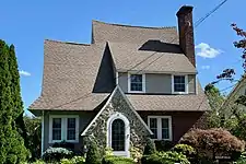 Tudor Revival style house
 Round Valley United Methodist Church
Notable people
People who were born in, residents of, or otherwise closely associated with Lebanon include:
- Alvah A. Clark (1840–1912), represented New Jersey's 4th congressional district in the United States House of Representatives from 1877 to 1881.[99]
- James N. Pidcock (1836–1899), represented New Jersey's 4th congressional district in the United States House of Representatives from 1885 to 1889.[100]
Points of interest
References
- 2019 Census Gazetteer Files: New Jersey Places, United States Census Bureau. Accessed July 1, 2020.
- US Gazetteer files: 2010, 2000, and 1990 , United States Census Bureau. Accessed September 4, 2014.
- 2012 New Jersey Legislative District Data Book, Rutgers University Edward J. Bloustein School of Planning and Public Policy, March 2013, p. 103.
- Directory, Borough of Lebanon. Accessed May 6, 2020.
- 2020 New Jersey Mayors Directory, New Jersey Department of Community Affairs. Accessed February 1, 2020.
- Borough Administrator / Clerk, Borough of Lebanon. Accessed May 6, 2020.
- U.S. Geological Survey Geographic Names Information System: Borough of Lebanon, Geographic Names Information System. Accessed March 7, 2013.
- DP-1 - Profile of General Population and Housing Characteristics: 2010 for Lebanon borough, Hunterdon County, New Jersey Archived 2020-02-12 at Archive.today, United States Census Bureau. Accessed November 15, 2012.
- Municipalities Sorted by 2011-2020 Legislative District, New Jersey Department of State. Accessed February 1, 2020.
- Profile of General Demographic Characteristics: 2010 for Lebanon borough Archived 2014-04-24 at the Wayback Machine, New Jersey Department of Labor and Workforce Development. Accessed November 15, 2012.
- Annual Estimates of the Resident Population for Minor Civil Divisions in New Jersey: April 1, 2010 to July 1, 2019, United States Census Bureau. Accessed May 21, 2020.
- GCT-PH1 Population, Housing Units, Area, and Density: 2010 - State -- County Subdivision from the 2010 Census Summary File 1 for New Jersey Archived 2020-02-12 at Archive.today, United States Census Bureau. Accessed November 15, 2012.
- Look Up a ZIP Code for Lebanon, NJ, United States Postal Service. Accessed November 15, 2012.
- Zip Codes, State of New Jersey. Accessed August 28, 2013.
- Area Code Lookup - NPA NXX for Lebanon, NJ, Area-Codes.com. Accessed August 28, 2013.
- U.S. Census website , United States Census Bureau. Accessed September 4, 2014.
- Geographic codes for New Jersey, Missouri Census Data Center. Accessed September 1, 2019.
- US Board on Geographic Names, United States Geological Survey. Accessed September 4, 2014.
- Table 7. Population for the Counties and Municipalities in New Jersey: 1990, 2000 and 2010, New Jersey Department of Labor and Workforce Development, February 2011. Accessed November 15, 2012.
- Snyder, John P. The Story of New Jersey's Civil Boundaries: 1606-1968, Bureau of Geology and Topography; Trenton, New Jersey; 1969. p. 156. Accessed October 26, 2012.
- About Us, Borough of Lebanon. Accessed November 20, 2019.
- DeMarco, Megan. "Voters to decide whether to merge two Princetons into one", The Star-Ledger, November 3, 2011. Accessed January 8, 2017. "There are 22 sets of 'doughnut towns' in New Jersey, those where one town wraps around the other town". Note that following voter approval of the Princeton merger, 21 pairs of "doughnut towns" remain.
- Map of County Municipalities, Hunterdon County, New Jersey. Accessed November 15, 2019.
- New Jersey Municipal Boundaries, New Jersey Department of Transportation. Accessed November 15, 2019.
- Census Estimates for New Jersey April 1, 2010 to July 1, 2019, United States Census Bureau. Accessed May 21, 2020.
- Fifteenth Census of the United States : 1930 - Population Volume I, United States Census Bureau, p. 716. Accessed November 15, 2012.
- Table 6. New Jersey Resident Population by Municipality: 1930 - 1990, New Jersey Department of Labor and Workforce Development. Accessed June 28, 2015.
- Census 2000 Profiles of Demographic / Social / Economic / Housing Characteristics for Lebanon borough, New Jersey Archived 2004-01-20 at the Wayback Machine, United States Census Bureau. Accessed November 15, 2012.
- DP-1: Profile of General Demographic Characteristics: 2000 - Census 2000 Summary File 1 (SF 1) 100-Percent Data for Lebanon borough, Hunterdon County, New Jersey Archived 2020-02-12 at Archive.today, United States Census Bureau. Accessed November 15, 2012.
- DP03: Selected Economic Characteristics from the 2006-2010 American Community Survey 5-Year Estimates for Lebanon borough, Hunterdon County, New Jersey Archived 2020-02-12 at Archive.today, United States Census Bureau. Accessed November 15, 2012.
- Inventory of Municipal Forms of Government in New Jersey, Rutgers University Center for Government Studies, July 1, 2011. Accessed November 18, 2019.
- Cerra, Michael F. "Forms of Government: Everything You've Always Wanted to Know, But Were Afraid to Ask" Archived 2014-09-24 at the Wayback Machine, New Jersey State League of Municipalities. Accessed November 30, 2014.
- "Forms of Municipal Government in New Jersey", p. 6. Rutgers University Center for Government Studies. Accessed June 3, 2015.
- Intro to the Borough Form of Government in the State of NJ, Lebanon Borough. Accessed May 18, 2007.
- 2020 Municipal Data Sheet, Borough of Lebanon. Accessed May 6, 2020.
- 2020 County and Municipal Directory, Hunterdon County, New Jersey. Accessed May 6, 2020.
- Borough of Lebanon, Hunterdon County, New Jersey. Accessed May 6, 2020.
- District Canvass November 6, 2018 Official Results, Hunterdon County, New Jersey, updated November 14, 2018. Accessed January 1, 2019.
- District Canvass November 7, 2017 Official Results, Hunterdon County, New Jersey, updated November 9, 2017. Accessed January 1, 2018.
- Hunterdon County District Canvass November 8, 2016, General Election, Hunterdon County, New Jersey, updated November 10, 2016. Accessed January 30, 2017.
- "The Lebanon Borough Council welcomes Councilwoman Melissa Saharic.", The Lebanon Lantern, Autumn 2019. Accessed November 20, 2019. "I want to thank Mike Piagentini for his service to Lebanon Boro on the town council. Mike resigned in July as his family relocated to Clinton Township. Congratulations and welcome to Melissa Saharic, who was voted onto the council to fill Mike’s vacancy in August."
- O'Brien, Walter. "Lebanon Borough reorganizes after run-off election", Hunterdon Review, January 4, 2017. Accessed May 15, 2017. "Attorney Judith Novack swore in Republican Jeffrey Schneider and Democrat Marlene Baldinger for three-year terms, and Republican Michael Piagentini for one-year unexpired term. Baldinger replaced former Councilwoman Barbara 'Bonnie' Schmidt after a Tuesday, Jan. 3, run-off election in the borough in when Baldiner garnered 183 votes and Schmidt 135. The two had tied for the second of three three-year terms after Schneider had taken in the most votes of the three in November."
- Plan Components Report, New Jersey Redistricting Commission, December 23, 2011. Accessed February 1, 2020.
- 2019 New Jersey Citizen's Guide to Government, New Jersey League of Women Voters. Accessed October 30, 2019.
- Districts by Number for 2011-2020, New Jersey Legislature. Accessed January 6, 2013.
- Directory of Representatives: New Jersey, United States House of Representatives. Accessed June 1, 2020.
- About Cory Booker, United States Senate. Accessed January 26, 2015. "He now owns a home and lives in Newark's Central Ward community."
- Biography of Bob Menendez, United States Senate, January 26, 2015. "He currently lives in Paramus and has two children, Alicia and Robert."
- Senators of the 116th Congress from New Jersey. United States Senate. Accessed April 17, 2019. "Booker, Cory A. - (D - NJ) Class II; Menendez, Robert - (D - NJ) Class I"
- Legislative Roster 2018-2019 Session, New Jersey Legislature. Accessed January 22, 2018.
- District 23 Legislators, New Jersey Legislature. Accessed January 22, 2018.
- About the Board, Hunterdon County, New Jersey. Accessed January 8, 2015.
- John King, Hunterdon County, New Jersey. Accessed January 8, 2015.
- Suzanne Lagay, Hunterdon County, New Jersey. Accessed January 8, 2015.
- J. Matthew Holt, Hunterdon County, New Jersey. Accessed January 8, 2015.
- John E. Lanza, Hunterdon County, New Jersey. Accessed January 8, 2015.
- Robert G. Walton, Hunterdon County, New Jersey. Accessed January 8, 2015.
- Hunterdon County Board of Chosen Freeholders, Hunterdon County, New Jersey. Accessed January 8, 2015.
- Hunterdon County Clerk Mary H. Melfi, Hunterdon County, New Jersey. Accessed January 8, 2015.
- Frederick W. Brown; Hunterdon County Sheriff, Hunterdon County, New Jersey. Accessed January 8, 2015.
- Surrogate Susan J. Hoffman, Hunterdon County, New Jersey. Accessed January 8, 2015.
- 2014 Elected Officials, Hunterdon County, New Jersey. Accessed January 8, 2015.
- 2014 County and Municipal Guide ... Hunterdon County Now, Hunterdon County, New Jersey. Accessed January 8, 2015.
- Voter Registration Summary - Hunterdon, New Jersey Department of State Division of Elections, March 23, 2011. Accessed November 15, 2012.
- "Presidential General Election Results - November 6, 2012 - Hunterdon County" (PDF). New Jersey Department of Elections. March 15, 2013. Retrieved December 24, 2014.
- "Number of Registered Voters and Ballots Cast - November 6, 2012 - General Election Results - Hunterdon County" (PDF). New Jersey Department of Elections. March 15, 2013. Retrieved December 24, 2014.
- 2008 Presidential General Election Results: Hunterdon County, New Jersey Department of State Division of Elections, December 23, 2008. Accessed November 15, 2012.
- 2004 Presidential Election: Hunterdon County, New Jersey Department of State Division of Elections, December 13, 2004. Accessed November 15, 2012.
- "Governor - Hunterdon County" (PDF). New Jersey Department of Elections. January 29, 2014. Retrieved December 24, 2014.
- "Number of Registered Voters and Ballots Cast - November 5, 2013 - General Election Results - Hunterdon County" (PDF). New Jersey Department of Elections. January 29, 2014. Retrieved December 24, 2014.
- 2009 Governor: Hunterdon County Archived 2012-10-17 at the Wayback Machine, New Jersey Department of State Division of Elections, December 31, 2009. Accessed November 15, 2012.
- "National Register Information System – (#09000652)". National Register of Historic Places. National Park Service. November 2, 2013.
- "New Jersey and National Registers of Historic Places - Hunterdon County" (PDF). New Jersey Department of Environmental Protection - Historic Preservation Office. September 30, 2020. p. 10.
- Parsekian, Ann; Armstrong, Janice; Bertland, Dennis (December 2007). "National Register of Historic Places Inventory/Nomination: Lebanon Historic District". National Park Service.
- Lebanon Borough Board of Education District Policy 0110 - Identification, Lebanon Borough School District. Accessed May 6, 2020. "Purpose: The Board of Education exists for the purpose of providing a thorough and efficient system of free public education in grades Kindergarten through eight in the Lebanon Borough School District. Composition: The Lebanon Borough School District is comprised of all the area within the municipal boundaries of the Borough of Lebanon."
- 2019-2020 Public School Directory, Hunterdon County Department of Education. Accessed May 6, 2020.
- District information for Lebanon Borough School District, National Center for Education Statistics. Accessed April 1, 2020.
- Guion, Payton. "These 43 N.J. school districts have fewer than 200 students", NJ Advance Media for NJ.com, September 2017. Accessed January 30, 2020. "Based on data from the state Department of Education from the last school year and the Census Bureau, NJ Advance Media made a list of the smallest of the small school districts in the state, excluding charter schools and specialty institutions.... 9. Lebanon Borough; Enrollment: 101; Grades: Pre-K-6; County: Hunterdon; Town population: 1,358"
- Clinton Township Middle School, Clinton Township School District. Accessed May 6, 2020.
- Clinton Township Middle School 2016 Report Card Narrative, New Jersey Department of Education. Accessed May 6, 2020. "Opened in 2007, the Clinton Township Middle School is the newest school in the district. It serves approximately 415 seventh and eighth grade students. The student body is comprised of Clinton Township students, Lebanon Borough students, and a number of School Choice students."
- School data for Clinton Township Middle School, National Center for Education Statistics. Accessed April 1, 2020.
- About the North Hunterdon-Voorhees Regional High School District, North Hunterdon-Voorhees Regional High School District. Accessed February 24, 2015. "North Hunterdon High School educates students from: Bethlehem Township, Clinton Town, Clinton Township, Franklin Township, Lebanon Borough, Union Township; Voorhees High School educates students from: Califon, Glen Gardner, Hampton, High Bridge, Lebanon Township, Tewksbury Township"
- Information Regarding Choice of District School, North Hunterdon-Voorhees Regional High School District. Accessed February 24, 2015. "In the past, parents and students of the North Hunterdon High School sending districts were able to select either North Hunterdon High School or Voorhees High School as their school of choice.... As our student population continued to grow and our two high schools reached, and exceeded, 90% capacity, the option of choosing Voorhees was eliminated in the 2005-2006 school year for the North Hunterdon sending districts (Bethlehem Township, Clinton Township, Franklin Township, Lebanon Borough and Union Township – Clinton Town students still have choice as they are classmates at Clinton Public School with Glen Gardner students, who attend Voorhees)."
- About the District North Hunterdoon-Voorhees Regional High School District. Accessed February 24, 2015. "North Hunterdon High School educates students from: Bethlehem Township, Clinton Town, Clinton Township, Franklin Township, Lebanon Borough, Union Township; Voorhees High School educates students from: Califon, Glen Gardner, Hampton, High Bridge, Lebanon Township, Tewksbury Township"
- School data for North Hunterdon High School, National Center for Education Statistics. Accessed April 1, 2020.
- Voorhees High School 2015 Report Card Narrative, New Jersey Department of Education. Accessed June 3, 2016. "Voorhees High School has consistently ranked among the top high schools in New Jersey and was named a National Blue Ribbon School in 2015. With an enrollment of 1,095 students in grades 9-12, the school serves the communities of Califon, Glen Gardner, Hampton, High Bridge, Lebanon Township, and Tewksbury Township."
- About the North Hunterdon-Voorhees Regional High School District, North Hunterdon-Voorhees Regional High School District, updated November 16, 2015. Accessed June 3, 2016. "North Hunterdon High School educates students from: Bethlehem Township, Clinton Town, Clinton Township, Franklin Township, Lebanon Borough, Union Township; Voorhees High School educates students from: Califon, Glen Gardner, Hampton, High Bridge, Lebanon Township, Tewksbury Township"
- Heyboer, Kelly. "How to get your kid a seat in one of N.J.'s hardest-to-get-into high schools", NJ Advance Media for NJ.com, May 2017. Accessed November 18, 2019. "Hunterdon County's vo-tech district has three academies for high-achieving students, all operating in partnerships with local high schools.... The academies are open to all students in the county. Students in the 8th grade are required to submit an application, schedule an interview and take a placement exam."
- Emergency Services, Borough of Lebanon. Accessed November 20, 2019.
- Troop B Road Stations, New Jersey State Police. Accessed November 20, 2019.
- Home page, Lebanon Volunteer Fire Company. Accessed November 15, 2012.
- Home page, Clinton First Aid & Rescue Squad. Accessed November 15, 2012. "The Clinton First Aid & Rescue Squad is a nonprofit organization that provides pre-hospital Emergency Medical Services and Rescue Services (vehicle extrication, water rescue, collapse, trench, rope and confined-space rescue) to the Town of Clinton, and portions of Clinton Township, Lebanon Borough, Franklin Township and Union Township."
- Hunterdon County Mileage by Municipality and Jurisdiction, New Jersey Department of Transportation, May 2010. Accessed July 18, 2014.
- U.S. Route 22 Straight Line Diagram, New Jersey Department of Transportation, updated March 2017. Accessed November 20, 2019.
- Interstate 78 Straight Line Diagram, New Jersey Department of Transportation, updated March 2016. Accessed November 20, 2019.
- Lebabnon station, NJ Transit. Accessed October 17, 2013.
- Raritan Valley Line, NJ Transit. Accessed October 17, 2013.
- Hunterdon County Bus / Rail Connections, NJ Transit, backed up by the Internet Archive as of July 26, 2010. Accessed November 15, 2012.
- Alvah Augustus Clark, Biographical Directory of the United States Congress. Accessed September 3, 2007.
- James Nelson Pidcock, Biographical Directory of the United States Congress. Accessed September 3, 2007.
External links
| Wikimedia Commons has media related to Lebanon, New Jersey. |
| Wikivoyage has a travel guide for Lebanon (New Jersey). |
- Lebanon Borough website
- Hunterdon County webpage for Lebanon Borough
- Lebanon Borough School District
- Lebanon Borough School District's 2015–16 School Report Card from the New Jersey Department of Education
- School Data for the Lebanon Borough School District, National Center for Education Statistics
- Clinton Township School District
- North Hunterdon-Voorhees Regional High School District
- Hunterdon Land Trust Alliance
| Authority control |
|---|