Leechburg, Pennsylvania
Leechburg is a borough in southern Armstrong County in the U.S. state of Pennsylvania, 35 miles (56 km) northeast of Pittsburgh. As of the 2010 census it had a population of 2,156.[3] Leechburg was founded by David Leech, for whom it was later named, and was incorporated as a borough in 1850.
Leechburg, Pennsylvania | |
|---|---|
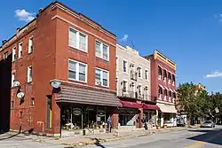 North side of 100 block of Market Street, looking east | |
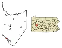 Location of Leechburg in Armstrong County, Pennsylvania. | |
 Leechburg Location of Leechburg in Armstrong County, Pennsylvania. | |
| Coordinates: 40°37′45″N 79°36′13″W | |
| Country | United States |
| State | Pennsylvania |
| County | Armstrong |
| Settled | 1832 |
| Incorporated | 1850 |
| Government | |
| • Type | Council-Mayor |
| • Mayor | Wayne Dobos |
| Area | |
| • Total | 0.48 sq mi (1.25 km2) |
| • Land | 0.44 sq mi (1.14 km2) |
| • Water | 0.04 sq mi (0.11 km2) |
| Elevation | 790 ft (240 m) |
| Population (2010) | |
| • Total | 2,156 |
| • Estimate (2019)[2] | 1,989 |
| • Density | 4,530.75/sq mi (1,748.01/km2) |
| Time zone | UTC-5 (Eastern (EST)) |
| • Summer (DST) | UTC-4 (EDT) |
| Zip code | 15656 |
| Area code(s) | 724 |
| FIPS code | 42-42280 |
Located along the Kiskiminetas River, Leechburg was a major port of the Pennsylvania Canal. Early in the 20th century, it was the site of extensive steel sheet works, foundries, cement plants, and productive coal mines. Leechburg was the first place where natural gas was used for industrial purposes.
Local government
Leechburg is governed by a Mayor and Council. Current officials and when their terms expire are:
Mayor: Wayne Dobos (R) 2021
Council:
Tom Foster (D), President 2023
Nancy Bono (D), Vice President 2021
Lorrie Bazella (R) 2021
Ruth Bender (D) 2023
Megan Goedicke (D) 2023
Chuck Pascal (D) 2021
Alan Tarr (D) 2021
Federal and state representatives
Leechburg is in Pennsylvania's 15th Congressional District, represented in Congress by Rep. Glenn Thompson (R).
At the state level, Leechburg is in the 41st Senatorial District, represented by State Senator Joe Pittman (R), and in the 55th Legislative District, represented by Rep. Jason Silvis (R).
Geography
Leechburg is located at 40°37′45″N 79°36′13″W (40.629304, -79.603727).[4] Elevations range from 780 feet (240 m) to 1,080 feet (330 m) above sea level.
According to the United States Census Bureau, the borough has a total area of 0.46 square miles (1.2 km2), of which 0.42 square miles (1.1 km2) is land and 0.039 square miles (0.1 km2), or 8.62%, is water.[3]
The town is bordered by the Kiskiminetas River to the south, on the border of Westmoreland County, and Gilpin Township to the north.
Demographics
| Historical population | |||
|---|---|---|---|
| Census | Pop. | %± | |
| 1860 | 359 | — | |
| 1870 | 368 | 2.5% | |
| 1880 | 1,123 | 205.2% | |
| 1890 | 1,921 | 71.1% | |
| 1900 | 2,459 | 28.0% | |
| 1910 | 3,624 | 47.4% | |
| 1920 | 3,991 | 10.1% | |
| 1930 | 4,489 | 12.5% | |
| 1940 | 4,275 | −4.8% | |
| 1950 | 4,042 | −5.5% | |
| 1960 | 3,545 | −12.3% | |
| 1970 | 2,999 | −15.4% | |
| 1980 | 2,682 | −10.6% | |
| 1990 | 2,504 | −6.6% | |
| 2000 | 2,386 | −4.7% | |
| 2010 | 2,156 | −9.6% | |
| 2019 (est.) | 1,989 | [2] | −7.7% |
| Sources:[5][6][7] | |||
As of the census[6] of 2000, there were 2,386 people, 1,109 households, and 645 families residing in the borough. The population density was 5,320.9 people per square mile (2,047.2/km²). There were 1,193 housing units at an average density of 2,660.5 per square mile (1,023.6/km²). The racial makeup of the borough was 97.53% White, 1.26% African American, 0.04% Native American, 0.17% Asian, 0.04% from other races, and 0.96% from two or more races. Hispanic or Latino of any race were 0.67% of the population.
There were 1,109 households, out of which 23.4% had children under the age of 18 living with them, 43.2% were married couples living together, 10.7% had a female householder with no husband present, and 41.8% were non-families. 39.1% of all households were made up of individuals, and 23.1% had someone living alone who was 65 years of age or older. The average household size was 2.14 and the average family size was 2.85.
The borough median age of 43 years was significantly more than the county median age of 40 years. The distribution by age group was 21.1% under the age of 18, 6.4% from 18 to 24, 26.2% from 25 to 44, 22.5% from 45 to 64, and 23.7% who were 65 years of age or older. The median age was 43 years. For every 100 females, there were 83.7 males. For every 100 females age 18 and over, there were 78.5 males.
According to the US Census Bureau, in 2012 the median household income in the borough was $35,682 and the median family income was $45,563. 17.8% of the population, 14.4% of families, 29.3% of children, and 8.8% of those 65 or older had income below the poverty level.[8]
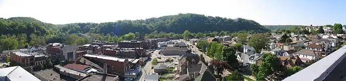 Panoramic view facing west showing approximately 160 degrees of downtown Leechburg from on top of the highrise located at 2nd and Main Street |
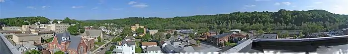 Panoramic view facing east showing approximately 180 degrees of downtown Leechburg from on top of the highrise located at 2nd and Main Street |
History
Leechburg was founded in 1850 by David Leech. Prior to 1850, the settlement was known as White Plains. David Leech purchased the land from a local Native American known as White Maddock.
Notable people
- Blake Foster, celebrity
- John Phillips, U.S. Ambassador to Italy
- Mickey Morandini, Olympic athlete and former All-Star MLB second baseman
- Alex Kroll, professional football player and CEO of Young & Rubicam
- Joseph Grant Beale, Member of Congress and industrialist
Education
The children of Leechburg are educated by the Leechburg Area School District. The school district consists of Leechburg, Gilpin Township and West Leechburg Borough.
Cemeteries
- Leechburg Cemetery[9]
References
- "2019 U.S. Gazetteer Files". United States Census Bureau. Retrieved July 28, 2020.
- "Population and Housing Unit Estimates". United States Census Bureau. May 24, 2020. Retrieved May 27, 2020.
- "Geographic Identifiers: 2010 Demographic Profile Data (G001): Leechburg borough, Pennsylvania". U.S. Census Bureau, American Factfinder. Archived from the original on February 12, 2020. Retrieved July 30, 2013.
- "US Gazetteer files: 2010, 2000, and 1990". United States Census Bureau. 2011-02-12. Retrieved 2011-04-23.
- "Census of Population and Housing". U.S. Census Bureau. Retrieved 11 December 2013.
- "U.S. Census website". United States Census Bureau. Retrieved 2008-01-31.
- "Incorporated Places and Minor Civil Divisions Datasets: Subcounty Resident Population Estimates: April 1, 2010 to July 1, 2012". Population Estimates. U.S. Census Bureau. Archived from the original on 11 June 2013. Retrieved 11 December 2013.
- "U.S. Census website". United States Census Bureau. Retrieved 2014-02-17.
- "Leechburg Cemetery". Geographic Names Information System. United States Geological Survey.
External links
| Wikimedia Commons has media related to Leechburg, Pennsylvania. |
Municipalities and communities of Armstrong County, Pennsylvania, United States | ||
|---|---|---|
| City | 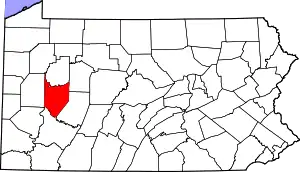 | |
| Boroughs | ||
| Townships | ||
| CDPs | ||
| Unincorporated communities |
| |
| ||
| Counties |  Map of the Pittsburgh Tri-State with green counties in the metropolitan area and yellow counties in the combined area | |
|---|---|---|
| Major cities | ||
| Cities and towns 15k–50k (in 2010) | ||
| Airports | ||
| Topics | ||
| ||
