Rayburn Township, Armstrong County, Pennsylvania
Rayburn Township is a township in Armstrong County, Pennsylvania, United States. The population was 1,907 at the 2010 census.[3]
Rayburn Township, Pennsylvania | |
|---|---|
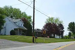 Along Pennsylvania Route 85 at Sunnyside | |
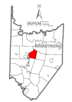 Map of Armstrong County, Pennsylvania highlighting Rayburn Township | |
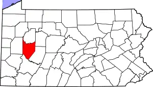 Map of Armstrong County, Pennsylvania | |
| Country | United States |
| State | Pennsylvania |
| County | Armstrong |
| Settled | 1784 |
| Incorporated | 1890 |
| Area | |
| • Total | 12.10 sq mi (31.33 km2) |
| • Land | 11.85 sq mi (30.69 km2) |
| • Water | 0.25 sq mi (0.64 km2) |
| Population (2010) | |
| • Total | 1,907 |
| • Estimate (2016)[2] | 1,821 |
| • Density | 153.70/sq mi (59.34/km2) |
| Time zone | UTC-5 (Eastern (EST)) |
| • Summer (DST) | UTC-4 (EDT) |
| FIPS code | 42-005-63560 |
Geography
Rayburn Township is located in central Armstrong County and is bordered to the west by the Allegheny River and the borough of Kittanning, the county seat. Cowanshannock Creek flows through the township into the Allegheny River.[4]
According to the United States Census Bureau, the township has a total area of 12.1 square miles (31.3 km2), of which 11.9 square miles (30.7 km2) is land and 0.23 square miles (0.6 km2), or 2.04%, is water.[3]
Demographics
| Historical population | |||
|---|---|---|---|
| Census | Pop. | %± | |
| 2010 | 1,907 | — | |
| 2016 (est.) | 1,821 | [2] | −4.5% |
| U.S. Decennial Census[5] | |||
As of the census[6] of 2000, there were 1,811 people, 694 households, and 526 families residing in the township. The population density was 152.4 people per square mile (58.8/km2). There were 737 housing units at an average density of 62.0/sq mi (23.9/km2). The racial makeup of the township was 99.06% White, 0.33% African American, 0.28% from other races, and 0.33% from two or more races. Hispanic or Latino of any race were 0.61% of the population.
There were 694 households, out of which 36.5% had children under the age of 18 living with them, 64.8% were married couples living together, 8.1% had a female householder with no husband present, and 24.2% were non-families. 20.3% of all households were made up of individuals, and 10.7% had someone living alone who was 65 years of age or older. The average household size was 2.57 and the average family size was 2.97.
The township median age of 38 years was less than that of the county median age of 40 years. The distribution by age group was 25.7% under the age of 18, 6.9% from 18 to 24, 28.5% from 25 to 44, 24.0% from 45 to 64, and 14.8% who were 65 years of age or older. The median age was 38 years. For every 100 females there were 96.2 males. For every 100 females age 18 and over, there were 91.1 males.
The median income for a household in the township was $29,830, and the median income for a family was $33,276. Males had a median income of $30,139 versus $20,433 for females. The per capita income for the township was $14,490. About 13.9% of families and 17.1% of the population were below the poverty line, including 25.3% of those under age 18 and 10.0% of those age 65 or over.
Cemeteries
References
- "2016 U.S. Gazetteer Files". United States Census Bureau. Retrieved Aug 13, 2017.
- "Population and Housing Unit Estimates". Retrieved June 9, 2017.
- "Geographic Identifiers: 2010 Demographic Profile Data (G001): Rayburn township, Armstrong County, Pennsylvania". U.S. Census Bureau, American Factfinder. Archived from the original on February 10, 2020. Retrieved August 1, 2013.
- "Cowanshannock Creek". Geographic Names Information System. United States Geological Survey. Retrieved 2010-11-15.
- "Census of Population and Housing". Census.gov. Retrieved June 4, 2016.
- "U.S. Census website". United States Census Bureau. Retrieved 2008-01-31.
- "County Home Cemetery". Geographic Names Information System. United States Geological Survey.
- "Kittanning Cemetery". Geographic Names Information System. United States Geological Survey.
- "Pine Creek Baptist Church Cemetery". Geographic Names Information System. United States Geological Survey.
- "Saint Joseph Cemetery". Geographic Names Information System. United States Geological Survey.
- "Saint Marys Cemetery". Geographic Names Information System. United States Geological Survey.
Municipalities and communities of Armstrong County, Pennsylvania, United States | ||
|---|---|---|
| City | | |
| Boroughs | ||
| Townships | ||
| CDPs | ||
| Unincorporated communities |
| |
| ||
| Counties |  Map of the Pittsburgh Tri-State with green counties in the metropolitan area and yellow counties in the combined area | |
|---|---|---|
| Major cities | ||
| Cities and towns 15k–50k (in 2010) | ||
| Airports | ||
| Topics | ||
| ||