Leetsdale, Pennsylvania
Leetsdale is a borough in Allegheny County, Pennsylvania, along the Ohio River. It is part of the Pittsburgh Metro Area. The population was 1,218 at the 2010 census.[3]
Leetsdale, Pennsylvania | |
|---|---|
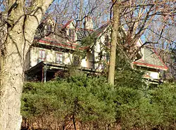 Elmridge, a historic site in the borough | |
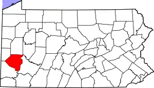
 Location in Allegheny County and the U.S. state of Pennsylvania. | |
| Coordinates: 40°34′0″N 80°12′41″W | |
| Country | United States |
| State | Pennsylvania |
| County | Allegheny |
| Incorporated | March 28, 1904 |
| Government | |
| • Mayor | Peter A. Poninsky (D) |
| Area | |
| • Total | 1.18 sq mi (3.05 km2) |
| • Land | 1.00 sq mi (2.59 km2) |
| • Water | 0.17 sq mi (0.45 km2) |
| Population (2010) | |
| • Total | 1,218 |
| • Estimate (2019)[2] | 1,157 |
| • Density | 1,157.00/sq mi (446.58/km2) |
| Time zone | UTC-5 (Eastern (EST)) |
| • Summer (DST) | UTC-4 (EDT) |
| FIPS code | 42-42392 |
| Website | leetsdaleboro |
History
Leetsdale was incorporated on March 28, 1904. Leetsdale at one time had a formidable industrial manufacturing base, with a Bethlehem Steel mill that closed in the late 1970s. The site of the mill on the shore of the Ohio River is now the Leetsdale Industrial Park, or the Port of Leetsdale, and is home to facilities leased, by The Buncher Company, to a number of companies of varying sizes.[4]
Leetsdale is also home to Elmridge, or the James Gardiner Coffin/John Walker house, which is listed on the National Register of Historic Places.[5]
Geography
Leetsdale is located at 40°34′0″N 80°12′41″W (40.566667, -80.211274).[6]
According to the United States Census Bureau, the borough has a total area of 1.1 square miles (2.8 km2), of which 1.0 square mile (2.6 km2) is land and 0.2 square miles (0.52 km2), or 13.91%, is water.
Surrounding communities
Leetsdale is bordered by Ambridge in Beaver County to the north, Leet Township to the northeast, and Edgeworth to the southeast. The borough includes the former town of Shields. The Ohio River forms the southwest border of the borough; across the river is Crescent Township.
Government and Politics
| Year | Republican | Democratic | Third Parties |
|---|---|---|---|
| 2016 | 46% 279 | 50% 302 | 4% 28 |
| 2012 | 45% 259 | 54% 311 | 1% 4 |
Demographics
| Historical population | |||
|---|---|---|---|
| Census | Pop. | %± | |
| 1910 | 1,904 | — | |
| 1920 | 2,311 | 21.4% | |
| 1930 | 2,774 | 20.0% | |
| 1940 | 2,332 | −15.9% | |
| 1950 | 2,411 | 3.4% | |
| 1960 | 2,153 | −10.7% | |
| 1970 | 1,862 | −13.5% | |
| 1980 | 1,604 | −13.9% | |
| 1990 | 1,387 | −13.5% | |
| 2000 | 1,337 | −3.6% | |
| 2010 | 1,218 | −8.9% | |
| 2019 (est.) | 1,157 | [2] | −5.0% |
| Sources:[9][10][11][12][13] | |||
As of the census[12] of 2000, there were 1,232 people, 586 households, and 370 families residing in the borough. The population density was 1,246.0 people per square mile (480.5/km2). There were 653 housing units at an average density of 660.4 per square mile (254.7/km2). The racial makeup of the borough was 89.20% White, 7.31% African American, 0.65% from other races, and 2.84% from two or more races. Hispanic or Latino of any race were 1.62% of the population.
There were 586 households, out of which 23.6% had children under the age of 18 living with them, 41.7% were married couples living together, 14.1% had a female householder with no husband present, and 40.8% were non-families. 38.0% of all households were made up of individuals, and 21.4% had someone living alone who was 65 years of age or older. The average household size was 2.14 and the average family size was 2.80.
In the borough the population was spread out, with 21.3% under the age of 18, 6.2% from 18 to 24, 26.9% from 25 to 44, 22.7% from 45 to 64, and 22.8% who were 65 years of age or older. The median age was 43 years. For every 100 females, there were 80.4 males. For every 100 females age 18 and over, there were 74.6 males.
The median income for a household in the borough was $28,672, and the median income for a family was $37,500. Males had a median income of $31,932 versus $25,750 for females. The per capita income for the borough was $19,172. About 9.6% of families and 12.8% of the population were below the poverty line, including 22.1% of those under age 18 and 10.2% of those age 65 or over.
References
- "2019 U.S. Gazetteer Files". United States Census Bureau. Retrieved July 28, 2020.
- "Population and Housing Unit Estimates". United States Census Bureau. May 24, 2020. Retrieved May 27, 2020.
- "Race, Hispanic or Latino, Age, and Housing Occupancy: 2010 Census Redistricting Data (Public Law 94-171) Summary File (QT-PL), Leetsdale borough, Pennsylvania". United States Census Bureau. Retrieved September 20, 2011.
- "Port of Leetsdale". Port of Pittsburgh Commission. Retrieved 28 December 2016.
- "National Register Information System". National Register of Historic Places. National Park Service. March 13, 2009.
- "US Gazetteer files: 2010, 2000, and 1990". United States Census Bureau. 2011-02-12. Retrieved 2011-04-23.
- EL. "2012 Allegheny County election". Pittsburgh Tribune-Review. Retrieved 15 October 2017.
- EL. "2016 Pennsylvani general election..." Pittsburgh Post-Gazette. Retrieved 15 October 2017.
- "Number and Distribution of Inhabitants:Pennsylvania-Tennessee" (PDF). Fifteenth Census. U.S. Census Bureau.
- "Number of Inhabitants: Pennsylvania" (PDF). 18th Census of the United States. U.S. Census Bureau. Retrieved 22 November 2013.
- "Pennsylvania: Population and Housing Unit Counts" (PDF). U.S. Census Bureau. Retrieved 22 November 2013.
- "U.S. Census website". United States Census Bureau. Retrieved 2008-01-31.
- "Annual Estimates of the Resident Population". U.S. Census Bureau. Archived from the original on 19 October 2013. Retrieved 22 November 2013.
External links
| Counties |  Map of the Pittsburgh Tri-State with green counties in the metropolitan area and yellow counties in the combined area | |
|---|---|---|
| Major cities | ||
| Cities and towns 15k–50k (in 2010) | ||
| Airports | ||
| Topics | ||
| ||
| Authority control |
|---|