Carnegie, Pennsylvania
Carnegie (/kɑːrˈneɪɡi/)[3] is a borough in Allegheny County, Pennsylvania, United States, and is part of the Pittsburgh metropolitan area. The population was 7,972 in the 2010 census.
Carnegie, Pennsylvania | |
|---|---|
 East Main Street, Carnegie, PA. | |
| Etymology: Andrew Carnegie | |
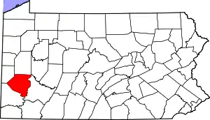
 Location in Allegheny County and the U.S. state of Pennsylvania. | |
.svg.png.webp) Location of Pennsylvania in the United States | |
| Coordinates: 40°24′25″N 80°05′12″W | |
| Country | United States |
| State | Pennsylvania |
| County | Allegheny |
| Incorporated | March 1, 1894 |
| Area | |
| • Total | 1.62 sq mi (4.19 km2) |
| • Land | 1.62 sq mi (4.19 km2) |
| • Water | 0.00 sq mi (0.00 km2) |
| Elevation | 833 ft (254 m) |
| Population (2010) | |
| • Total | 7,972 |
| • Estimate (2019)[2] | 7,806 |
| • Density | 4,824.47/sq mi (1,862.85/km2) |
| Time zone | UTC-5 (EST) |
| • Summer (DST) | UTC-4 (EDT) |
| ZIP code | 15106 |
| Area code(s) | 412 |
| FIPS code | 42-11336 |
| School District | Carlynton |
| Website | Borough of Carnegie |
Geography
Carnegie is located at 40°24′25″N 80°5′12″W. It is approximately 5 miles (8 km) southwest of Pittsburgh. Chartiers Creek runs through the center of the borough.
According to the United States Census Bureau, the borough has a total area of 1.6 square miles (4.1 km2), all of it land. Its average elevation is 833 ft (254 m) above sea level.[4]
Surrounding communities
Carnegie has four borders, including Rosslyn Farms to the north, Scott Township to the east, south and southwest, Collier Township to the west, and Robinson Township to the northwest.
History
Carnegie is named after Andrew Carnegie, who donated one of his libraries for the gesture.[5] It was incorporated on March 1, 1894 from the boroughs of Chartiers and Mansfield (separated by Chartiers Creek).[6] Later, the borough annexed part of Robinson Township (now Rosslyn Heights). Neighborhoods include Rosslyn Heights, Cubbage Hill, Irishtown, Forsythe Hill, Library Hill, and Old Mansfield.
Many neighborhoods were at one time or another mined for coal. The main employers were steel mills such as Superior Steel & Union Electric Steel. Carnegie had a rail yard that had connections to several railroads early in the twentieth century, including the Wabash Pittsburgh Terminal railroad, and the Pennsylvania Railroad.
On August 25, 1923, Carnegie was invaded by an estimated 10,000[7]–30,000 members of the Ku Klux Klan (from surrounding areas), there to celebrate a so-called "Karnegie Day" and target the heavily-Catholic town residents. The Klan's parade through town was resisted by local residents, resulting in a riot which left injuries on both sides and the death of a Klansman.[8][9][10]
In the 1970s, Carnegie suffered economically with the closure of the great steel mills such as J & L in and around Pittsburgh.
In 2004, Carnegie was significantly damaged by flooding as a result of Hurricane Ivan. Much of the commercial section of the borough, as well as the borough's Roman Catholic churches, was closed or damaged. But since 2014, Carnegie's Main Street has rebounded with many new restaurants and small businesses. It is becoming a popular Pittsburgh-area destination, especially on weekends.[11]
Culture
Carnegie is a walkable community with many interesting and unique stores and restaurants on its Main Street. Its park is home to a dog park, playground, tennis courts, a hockey rink, basketball courts, baseball fields, walking trails, and Pitcher Skate Park. The Andrew Carnegie Free Library & Music Hall is home to the Grand Army of the Republic Cpt. Thomas Espy Post and Stage 62 theater productions. Off the Wall Productions theater also makes its home in Carnegie, and hosts the annual Pittsburgh New Works Festival.
Carnegie is religiously diverse. There are two Orthodox Churches (Ukrainian and Russian), two Lutheran churches, a Ukrainian Catholic church, a Methodist church, an Episcopal church, a Polish Catholic church, a Roman Catholic Church (formerly 4), and a synagogue. In addition, the Attawheed Islamic Center opened in 2011, and the Indian Community Center in 2012.
Carnegie also has many local fraternal organizations including the VFW, FOE, American Legion, Elks, Polish Eagles, Polish Sportsmen, AOH, Ukrainian-American Citizens' Club, plus a number of smaller clubs.
Government and Politics
| Year | Republican | Democratic | Third Parties |
|---|---|---|---|
| 2016 | 43% 1,574 | 53% 1,944 | 4% 136 |
| 2012 | 42% 1,465 | 56% 1,945 | 2% 54 |
Education
Carnegie's students are served by the Carlynton School District. There is an elementary school within the Borough.
Demographics
| Historical population | |||
|---|---|---|---|
| Census | Pop. | %± | |
| 1900 | 7,330 | — | |
| 1910 | 10,009 | 36.5% | |
| 1920 | 11,516 | 15.1% | |
| 1930 | 12,497 | 8.5% | |
| 1940 | 12,663 | 1.3% | |
| 1950 | 12,105 | −4.4% | |
| 1960 | 11,887 | −1.8% | |
| 1970 | 10,864 | −8.6% | |
| 1980 | 10,099 | −7.0% | |
| 1990 | 9,278 | −8.1% | |
| 2000 | 8,389 | −9.6% | |
| 2010 | 7,972 | −5.0% | |
| 2019 (est.) | 7,806 | [2] | −2.1% |
| Sources:[14][15][16][17][18][19] | |||
As of the census[18] of 2000, there were 8,389 people, 3,967 households, and 2,134 families residing in the borough. The population density was 5,076.7 people per square mile (1,963.0/km²). There were 4,249 housing units at an average density of 2,571.3 per square mile (994.3/km²). The racial makeup of the borough was 91.32% White, 5.57% African American, 0.08% Native American, 1.23% Asian, 0.05% Pacific Islander, 0.39% from other races, and 1.36% from two or more races. Hispanic or Latino of any race were 0.99% of the population.
There were 3,967 households, out of which 22.7% had children under the age of 18 living with them, 37.4% were married couples living together, 13.2% had a female householder with no husband present, and 46.2% were non-families. 40.4% of all households were made up of individuals, and 18.3% had someone living alone who was 65 years of age or older. The average household size was 2.10 and the average family size was 2.86.
In the borough the population was spread out, with 19.4% under the age of 18, 8.1% from 18 to 24, 30.4% from 25 to 44, 22.0% from 45 to 64, and 20.1% who were 65 years of age or older. The median age was 40 years. For every 100 females, there were 85.0 males. For every 100 females age 18 and over, there were 81.0 males.
The median income for a household in the borough was $32,589, and the median income for a family was $41,371. Males had a median income of $30,792 versus $26,239 for females. The per capita income for the borough was $21,119. About 9.7% of families and 11.5% of the population were below the poverty line, including 19.4% of those under age 18 and 7.2% of those age 65 or over.
Notable people
Athletes
- Mike Ditka, Pro Football Hall of Fame member [20]
- Bernie Faloney, Canadian Football Hall of Fame member
- Skip Prosser, Former NCAA Division I basketball head coach for Wake Forest University
- Butts Wagner, Major League Baseball player, older brother of Honus Wagner
- Honus Wagner, Baseball Hall of Fame member[21]
Politicians
- Ruggero J. Aldisert, judge on the United States Court of Appeals
- James H. Duff, governor of Pennsylvania, 1947–1951; member of the U.S. Senate, 1951–1957
- James A. Wright, member of the U.S. House of Representatives, 1941–1945
See also
Gallery
 Forsythe Home, built around 1850, located at 920 Forsythe Road.
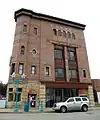 Husler Building, built in 1896, located at 1 West Main Street.
 The Andrew Carnegie Free Library, built in 1899, located at 300 Beechwood Avenue.
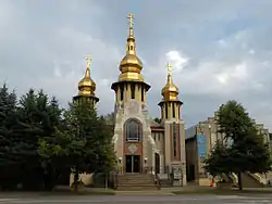 St. Peter & St. Paul Ukrainian Orthodox Church, built in 1906, located at 220 Mansfield Boulevard.
 St. Peter & St. Paul Ukrainian Orthodox Church and The Holy Virgin Russian Orthodox Church in Carnegie, PA.
 The Holy Virgin Russian Orthodox Church, built in 1920, located at 214 Mansfield Boulevard.
References
- "2019 U.S. Gazetteer Files". United States Census Bureau. Retrieved July 28, 2020.
- "Population and Housing Unit Estimates". United States Census Bureau. May 24, 2020. Retrieved May 27, 2020.
- "Carnegie". Random House Webster's Unabridged Dictionary.
- "US Board on Geographic Names". United States Geological Survey. 2007-10-25. Retrieved 2008-01-31.
- Ackerman, Jan (May 10, 1984). "Town names carry bit of history". Pittsburgh Post-Gazette. p. 1. Retrieved 31 October 2015.
- "Allegheny County - 2nd Class" (PDF). Retrieved 2008-03-16.
- Oyler, John. "Ku Klux Klan staged massive rally in Carnegie in August 1923," TribLive (July 16, 2014).
- Brown, Carole Gilbert. "Senior judge visits his boyhood home with book, stories: Aldisert writes of growing up in Carnegie," Pittsburgh Post-Gazette (OCT. 13, 2005).
- Tucker, Todd (2004), Notre Dame vs. the Klan: How the Fighting Irish Defeated the Ku Klux Klan, Loyola Press, ISBN 978-0-8294-1771-5, p. 133,
- Pegram, Thomas R. (2011), One Hundred Percent American: The Rebirth and Decline of the Ku Klux Klan in the 1920s, Rowman & Littlefield, ISBN 978-1-56663-711-4, p. 177.
- Batz, Bob, Jr. "Main Street in Carnegie lined with culinary charms: Main Street of this little borough south of the city is lined with culinary charms," Pittsburgh Post-Gazette (JUL 31, 2014).
- EL. "2012 Allegheny County election". Pittsburgh Tribune-Review. Retrieved 15 October 2017.
- EL. "2016 Pennsylvania general election results". Pittsburgh Post-Gazette. Retrieved 15 October 2017.
- "Population-Pennsylvania" (PDF). U.S. Census 1910. U.S. Census Bureau. Retrieved 22 November 2013.
- "Number and Distribution of Inhabitants:Pennsylvania-Tennessee" (PDF). Fifteenth Census. U.S. Census Bureau.
- "Number of Inhabitants: Pennsylvania" (PDF). 18th Census of the United States. U.S. Census Bureau. Retrieved 22 November 2013.
- "Pennsylvania: Population and Housing Unit Counts" (PDF). U.S. Census Bureau. Retrieved 22 November 2013.
- "U.S. Census website". United States Census Bureau. Retrieved 2008-01-31.
- "Annual Estimates of the Resident Population". U.S. Census Bureau. Archived from the original on 19 October 2013. Retrieved 22 November 2013.
- years - Pro Football Hall of Fame Archived January 17, 2007, at the Wayback Machine
- Reichler, Joseph L., ed. (1979) [1969]. The Baseball Encyclopedia (4th ed.). New York: Macmillan Publishing. ISBN 0-02-578970-8.
External links
| Wikimedia Commons has media related to Carnegie, Pennsylvania. |
- Borough of Carnegie (official site)
- . Encyclopædia Britannica (11th ed.). 1911.
- . Encyclopedia Americana. 1920.
- Historical Society of Carnegie & genealogy site
- https://web.archive.org/web/20090806052307/http://www.foe.com/index.aspx Fraternal Order of Eagles
- http://www.carnegiecarnegie.org/ Andrew Carnegie Free Library
- https://web.archive.org/web/20090624230113/http://www.pa.gov/portal/server.pt/community/government/3014 Government - Allegheny County
| Counties |  Map of the Pittsburgh Tri-State with green counties in the metropolitan area and yellow counties in the combined area | |
|---|---|---|
| Major cities | ||
| Cities and towns 15k–50k (in 2010) | ||
| Airports | ||
| Topics | ||
| ||
| Authority control |
|---|
| Preceded by Rosslyn Farms |
Bordering communities of Pittsburgh |
Succeeded by Green Tree |