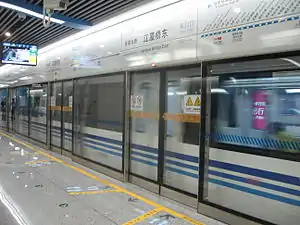
Line 1 (Ningbo Rail Transit)
Line 1 of Ningbo Rail Transit (Chinese: 宁波轨道交通1号线) is a rapid transit line in Ningbo. It starts from Gaoqiao Town in the west, crosses the central area of Ningbo, and reaches Beilun District in the east. The line started service on May 30, 2014.[1]
| Line 1 | |
|---|---|
| 1 | |
 A view of the Jiangxia Bridge East Station | |
| Overview | |
| Status | Operational |
| Owner | Ningbo |
| Locale | Ningbo, Zhejiang, China |
| Termini | Gaoqiao West Xiapu |
| Stations | 29 |
| Website | nbmetro.com |
| Service | |
| Type | Rapid transit |
| System | Ningbo Rail Transit |
| Operator(s) | Ningbo Rail Transit Co.,Ltd. |
| Depot(s) | Tiantongzhuang Depot, Jiangnan Coach Yard, Zhutang Village Coach Yard |
| History | |
| Opened | May 30, 2014 |
| Technical | |
| Line length | 46.165 km (28.69 mi) (total) |
| Number of tracks | 2 |
| Character | Underground Elevated |
| Track gauge | 1,435 mm (4 ft 8 1⁄2 in) |
| Electrification | Fully electrified (DC 1500V) |
| Operating speed | 80 km/h |
Route
Line 1 is the first metro line in Ningbo, stretching in the east-west direction. The Phase 1 section starts as elevated rail from Gaoqiao Town in the west and turns underground when it approaches Haishu District (Wangchun Bridge Station). The tunnel stretches under Zhongshan Road, an east-west arterial road in Ningbo while crossing Fenghua River to enter Yinzhou District. The route travels through the Ningbo East New Town, where Phase 1 terminates (Donghuan South Road Station). Phase 2 starts underground at Donghuan South Road Station and continues as elevated rail after Qiuga East Station. The route travels through rural area of Yinzhou District and Beilun District, before entering Downtown Beilun around Daqi Station. The final section travels to the eastern end of Downtown Beilun before terminating at Xiapu Station. Phase 1, connecting Gaoqiao, Xiapu, Yinzhou, and Ningbo East New Town, started service on May 30, 2014.[1] The rest section from Ningbo East New Town to Beilun District opened on March 19, 2016.[2] The line has 29 stations in total, of which 13 are elevated and the 16 are underground. Starting from March 2016, all 29 stations of Line 1 are operational.
Timeline
| Segment | Commencement | Length | Station(s) | Name |
|---|---|---|---|---|
| Gaoqiao West — Donghuan South Road | 30 May 2014[3] | 20.8 km (12.92 mi) | 20 | Phase 1 |
| Donghuan South Road — Xiapu | 19 March 2016[3] | 25.3 km (15.72 mi) | 9 | Phase 2 |
Stations

| Station name | Connections | Distance km |
Location | ||
|---|---|---|---|---|---|
| English | Chinese | ||||
| Gaoqiao West | 高桥西 | 0.00 | 0.00 | Haishu | |
| Gaoqiao | 高桥 | 1.52 | 1.52 | ||
| Liangzhu | 梁祝 | 1.42 | 2.94 | ||
| Lugang | 芦港 | 1.16 | 4.10 | ||
| Xujiacao Changle | 徐家漕长乐 | 0.98 | 5.08 | ||
| Wangchun Bridge | 望春桥 | 6 | 1.33 | 6.41 | |
| Zemin | 泽民 | 1.24 | 7.65 | ||
| Daqing Bridge | 大卿桥 | 4 | 1.10 | 8.75 | |
| Ximenkou | 西门口 | 0.78 | 9.53 | ||
| Gulou / Drum Tower | 鼓楼 | 2 | 0.97 | 10.50 | |
| Dongmenkou (Tianyi Square) | 东门口(天一广场) | 0.62 | 11.12 | ||
| Jiangxia Bridge East | 江厦桥东 | 0.94 | 12.06 | Yinzhou | |
| Zhoumeng North Road | 舟孟北路 | 0.89 | 12.95 | ||
| Sakura Park | 樱花公园 | 3 | 0.75 | 13.70 | |
| Fuming Road | 福明路 | 1.22 | 14.92 | ||
| Shiji Avenue | 世纪大道 | 0.90 | 15.82 | ||
| Haiyan North Road | 海晏北路 | 5 | 1.35 | 17.17 | |
| Fuqing North Road | 福庆北路 | 0.95 | 18.12 | ||
| Shengmo Road | 盛莫路 | 7 | 1.18 | 19.30 | |
| Donghuan South Road | 东环南路 | 1.50 | 20.80 | ||
| Qiuga East | 邱隘东 | 1.25 | 22.05 | ||
| Wuxiang | 五乡 | 3.25 | 25.30 | ||
| Baozhuang | 宝幢 | 4.22 | 29.52 | ||
| Wuga | 邬隘 | 6.45 | 35.97 | Beilun | |
| Daqi | 大碶 | 2.38 | 38.35 | ||
| Songhuajiang Road | 松花江路 | 6 | 2.15 | 40.5 | |
| Zhonghe Road | 中河路 | 2.40 | 42.90 | ||
| Changjiang Road | 长江路 | 1.38 | 44.28 | ||
| Xiapu | 霞浦 | 1.29 | 45.57 | ||
References
- (Chinese)今日上午10时左右宁波轨道交通1号线一期试运营
- "(Chinese) 宁波市轨道交通1号线二期开通试运营 - 宁波轨道交通 "". www.nbmetro.com. Retrieved 2019-12-24.
- "宁波轨道交通线路详细信息". 程轨通. Retrieved 24 December 2019.
| Wikimedia Commons has media related to Line 1, Ningbo Rail Transit. |