List of ghost towns in Florida
This is an incomplete List of ghost towns in Florida sortable by name, county, or coordinates. Note that the county names are modern (as of 2018); in several cases the ghost town, when inhabited, was in a different county than the modern one. A map of these locations is here:
| Town | County | Latitude/Longitude |
|---|---|---|
| Acron | Lake | 29°0.1'N 81°31.2'W |
| Acton | Polk | 28°3.2'N 81°56.0'W |
| Agricola | Polk | 27°47.3'N 81°53.3'W |
| Aladdin City | Miami-Dade | 25°34.6'N 80°27.2'W |
| Allenhurst | Brevard | 28°44.1'N 80°45.4'W |
| Andytown | Broward | 26°8.7'N 80°26.6'W |
| Angola | Manatee | 27°29'N 82°35'W |
| Anona | Pinellas | 27°53.6'N 82°49.9'W |
| Apix | Palm Beach | 26°56.6'N 80°20.6'W |
| Apoxsee | Osceola | 27°48.0'N 80°56.4'W |
| Arlington | Citrus | 28°52.2' 82°21.7'W |
| Atsena Otie Key | Levy | 29°7.3'N 83°1.6'W |
| Aurytown | Glades | 26°50.0'N 81°17.8'W |
| Aurytown | Pinellas | 28°4.8'N 82°49.9'W |
| Balm(inhabited) | Hillsborough | 27°44.5'N 82°12.2'W |
| Bareah | Polk | 27°39.6'N 81°37.5'W |
| Barrsville | Columbia | 30°0'N 82°35'W |
| Basinger | Okeechobee | 27°23.3'N 81°2.0'W |
| Bay Harbor (industrial) | Bay | 30°8.7'N 85°37.3'W |
| Bayview | Lake | 28°32.7'N 82°38.6'W |
| Bayview (inhabited) | Pinellas | 27°27.5'N 82°42.5'W |
| Bean City | Palm Beach | 26°40.9'N 80°45.7'W |
| Bermont | Charlotte | 26°56.8'N 81°45.7'W |
| Bethany | Manatee | 27°28.4'N 82°16.2'W |
| Birdon | Collier | 25°54±'N 81°18.6'W |
| Boyette | Hillsborough | 27°49.1'N 82°13.4'W |
| Brewster | Polk | 27°45.1'N 81°58.4'W |
| Bryant | Palm Beach | 26°50.9'N 80°36.8'W |
| Buchanan | Hardee | 27°24.7'N 81°47.7'W |
| Bullowville | Flagler | 21°25'N 81°09'N |
| Bunce Village | Pinellas | 27°38.7'N 82°44.3'W |
| Bunkerhill | Manatee | 27°35.7'N 82°12.4'W |
| Castor Town | Hillsborough | 27°35±'N 82°45.7'W |
| Centralia | Hernando | 28°36.9'N 82°32.7'W |
| Campville | Alachua | 29°39.9'N 82°7.1'W |
| Chetwynd | Lake | 28°52.6'N 81°55.0'W |
| Chevelier | Monroe | T54S R31E |
| Chicora | Polk | 27°43.8'N 81°59'W |
| Chokoloskee (inhabited) | Collier | 25°48.8'N 81°21.6'W |
| Chosen | Palm Beach | 26°42'N 80°46.8'W |
| Citrus Center | Glades | 26°48.8'N 81°14.9'W |
| Clifton | Brevard | 28°45.0'N 80°46.2'W |
| College Hill | Hardee | 27°37.7'N 81°52.3'W |
| Columbus | Suwannee | 30°23.1'N 83°10.4'W |
| Conant | Lake | 28°56.3'N 81°55.7'W |
| Cornwell | Highlands | 27°23.7'N 81°9.4'W |
| Cosme (inhabited) | Hillsborough | 28°06.5'N 82°34.4'W |
| Craig | Monroe[4] | 24.8379°N 80.7595°W |
| Crewsville | Hardee | 27°25.3'N 81°35.0'W |
| Cromanton (Tyndall Air Force Base) | Bay | 30°7.0'N 85°37.6'W |
| Croom (inhabited) | Hernando | 28°35.4'N 82°13.7'W |
| Cutler | Miami-Dade | 25°36.9'N 80°18.6'W |
| Deep Lake | Collier | 26°02.5'N 81°20.6'W |
| Deer Park (inhabited) | Osceola | 28°5.5'N 80°53.9'W |
| East Goose Creek | Wakulla | 30°6.3'N 84°15.7'W |
| Eden (inhabited) | Saint Lucie | 27°16.5'N 80°14.6'W |
| Edgeville | Manatee | 27°18.9'N 82°6.5'W |
| Eldora | Volusia | 28°54.6'N 80°49.2'W |
| Electra | Marion | 29°7.7'N 81°53.3'W |
| Ellaville | Madison | 30°23.2'N 83°10.4'W |
| Englewood | Orange | 28°23.7'N 81°30.2'W |
| Espanola (inhabited) | Flagler | 29°30.4 81°18.5'W |
| Ethel | Lake | 28°50.1'N 81°26.6'W |
| Fairmount | Citrus | |
| Fivay | Pasco | 28°19.9'N 82°38.4±'W |
| Flamingo | Monroe | 25°8.5'N 81°0'W |
| Fontaine | Brevard | 28°45.4'N 80°54.4'W |
| Fort Basinger | Highlands | 27°21.7'N 81°3.2'W |
| Fort Chokonikla | Hardee | 27°37.2'N 81°48.5'W |
| Fort Dade | Hillsborough | 27°35.8'N 82°45.7'W |
| Fort Dallas | Miami Dade | 25°46.6'N 80°12.1'W |
| Fort Denaud (inhabited) | Hendry | 26°44.7'N 81°27.9'W |
| Fort DeSoto | Pinellas | 27°38.2'N 82°44.2'W |
| Fort Drum | Okeechobee | 27°37.6'N 80°48.4'W |
| Fort Jefferson | Monroe | 24°37.7'N 82°52.4'W |
| Fort King | Marion | 29°11.2'N 82°5.0'W |
| Fort Kissimmee | Polk/Highlands | 27°35.5'N 81°9.4'W |
| Fort Lonesome | Hillsborough | 27°42.3'N 81°8.3'W |
| Fort Mosé | St. Johns | 29°55.8'N 81°19.3'W |
| Fort Pickens | Escambia | 30°19.5'N 87°16.8'W |
| Freeman | Hernando | 28°34'N 82°33'N |
| Fruitcrest | Palm Beach | 26°37.8'N 80°44.9'W |
| Gaiter | Marion | 29°0.5'N 82°20.6'W |
| Gamble Plantation | Manatee | 27°32'N 82°32'W |
| Gardena | Palm Beach | 26°37.0'N 80°50.7'W |
| Gardner | Hardee | 27°21.1'N 81°48.1'W |
| Garfield | Volusia | 28°52.1'N 81°13.5'W |
| Geerworth | Palm Beach | 26°40.7'N 80°32.3'W |
| Gillette | Manatee | 27°36.1'N 82°31.7'W |
| Gladecrest | Palm Beach | 26°37.8'N 80°34.1'W |
| Goodno | Glades | 26°46.1'N 81°18.7'W |
| Green Pond | Polk | 28°18.6'N 81°53.9'W |
| Greenbay | Polk | 27°50.2'N 81°55.5'W |
| Gulf City (inhabited) | Hillsborough | 27°42.3'N 82°27.8'W |
| Hague (inhabited) | Alachua | 29°46.2'N 82°25.3'W |
| Haile | Alachua | 37°41.4'N 82°34.4'W |
| Hall City | Glades | 26°52.7'N 81°19.6'W |
| Hampton Springs | Taylor | 30°05.0'N 83°39.1'W |
| Hardaway | Gadsden | 30°37.9'N 84°44.2'W |
| Harker | Collier | 26°20.6′ N 81°20.6′W |
| Hawkinsville | Lake | 29°2.2'N 81°25.2'W |
| Heidtville | Marion | 29°3.6'N 82°20.6'W |
| Helen | Leon | 30°18.5'N 84°24.0'W |
| Hicoria | Highlands | 27°9.1'N 81°21.2'W |
| Hilolo | Okeechobee | 27°26.9'N 80°46.3'W |
| Holopaw (inhabited) | Osceola | 28°8.2'N 81°4.6'W |
| Hopewell | Hillsborough | 27°55.7'N 82°07.5'W |
| Hopkins | Brevard | 28°4.2'N 80°35.9'W |
| Illahaw | Osceola | 28°1.1'N 81°1.9'W |
| Indian Key | Monroe | 24°53'N 80°41'W |
| Indiantown (inhabited) | Martin | 27°1.8'N 80°29.0' |
| Island Grove | Alachua | 29°27.2'N 82°6.4'W |
| Jane Jay | Polk | 27°40.3'N 81°49.2'W |
| Jerome (inhabited) | Collier | 25°59.9'N 81°20.8'W |
| Jessamine | Pasco | 28°24.8'N 82°16.2'W |
| Juliette | Marion | 29°6.2'N 82°26.4'W |
| Juno (Inhabited) | Palm Beach | 26°50.6'N 80°3.6'W |
| Kenansville | Osceola | 80°59.3'N 27°52.6'W |
| Kerr City | Marion | 29°22.5'N 81°46.9'W |
| Kicco | Osceola | |
| Kismet | Lake | 29°2.5'N 81°37.5'W |
| Koreshan (Inhabited) | Lee | 26°26.0'N 81°49.0'W |
| Kreamer Island | Palm Beach | 26°45.4'N 80°44.0'W |
| Lake Fern (inhabited) | Hillsborough | 28°8.9'N 82°34.8'W |
| Lake Jackson Mounds | Leon | 30°30.0'N 84°18.5'W |
| Lawtey (inhabited) | Bradford | 30°2.6'N 82°4.3'W |
| Leno | Columbia | 30°2.6'N 82°4.3'W |
| Limona (inhabited) | Hillsborough | 27°57.1'N 82°18.6'W |
| Linden | Sumter | 28°33.7'N 82°2.0'W |
| Liverpool | DeSoto | 27°2.7'N 81°58.2'W |
| Locosee | Osceola | 27°45.3'N 80°54.7'W |
| Lulu (inhabited) | Columbia | 30°6.4'N 82°29.5'W |
| Mabel | Sumter | 28°34.7'N 81°58.4'W |
| Magnolia | Wakulla | 30°13.2'N 84°10.5'W |
| Manasota | Charlotte | 27°0.8'N 82°24.2'W |
| Manhattan | Manatee | 27°23.1'N 82°19.2'W |
| Mannfield | Citrus | 28°47.0'N 82°26.6'W |
| Midland | Polk | 27°44.3'N 81°37.3'W |
| Minton's Corner | Brevard | 28°4.7'N 80°40.3'W |
| Modello (Dania Beach) | Broward | 26°3.0'N 80°8.8'W |
| Moffit | Hardee | 27°27.3'N 81°47.8'W |
| Montague | Marion | 29°9.0'N 82°4.4'W |
| Montbrook | Levy | 29°19.6'N 82°27.0'W |
| Muscogee | Escambia | 30°36.4'N 87°24.8'W |
| Naranja (inhabited) | Miami-Dade | 25°31.0'N 80°25.3'W |
| Narcoossee (inhabited) | Osceola | 28°17.9'N 81°14.3'W |
| Negro Fort | Franklin | 29°56.4'N 85°0.7'W |
| Neilson | Polk | 27°40.7'N 81°30.1'W |
| Newhall | Glades | 26°51.1'N 81°7.4'W |
| New Troy | Lafayette | 30°0.4'N 83°0.8'W |
| Newnansville | Alachua | 29°48.5'N 82°28.6'W |
| Newport | Wakulla | 30°12.0'N 84°10.8'W |
| Nittaw | Osceola | 27°57.2'N 81°0.0'W |
| Oakgrove | Hernando | |
| Okeelanta | Palm Beach | 26°36.6'N 80°42.7'W |
| Old Bethel | Okaloosa | 30°47.5'N 86°36.2'W |
| Old Providence | Union | 30°0.9'N 82°33.6'W |
| Old Town | Lake | 29°2.2'N 81°25.2'W |
| Old Venus | Highlands | 27°4.0'N 81°21.5'W |
| Olympia | Martin | 27°3.2'N 80°7.9'W |
| Ona | Hardee | 27°28.9'N 81°55.2'W |
| Orange Center | Orange | 28°23.7'N 81°30.2'W |
| Orleans | Citrus | 25°47.5'N 82°22.5'W |
| Orsino | Brevard | 28°31.6'N 80°39.8'W |
| Ortona | Glades | 26°48.7'N 81°18.9'W |
| Osceola | Seminole | 28°47.6'N 81°3.5'W |
| Oslo | Indian River | 27°35.2'N 80°22.8'W |
| Osowaw Junction | Okeechobee | 27°34.8'N 80°50.1'W |
| Old Venus | Highlands | |
| Palma Sola (inhabited) | Manatee | 27°30.7'N 82°37.9'W |
| Parmalee | Manatee | 27°22.3'N 82°13.2'W |
| Parramore | Jackson | 30°52.3'N 84°59.9'W |
| Pembroke (industrial) | Polk | 27°47.2'N 81°48.3'W |
| Pennsuco | Miami-Dade | 25°53.7'N 80°22.7'W |
| Perky | Monroe | 24°38.9'N 81°34.3'W |
| Peru | Hillsborough | 27°52.7'N 82°19.1'W |
| Peters | Miami-Dade | 25°35.9'N 80°21.2'W |
| Picnic | Hillsborough | 27°45.7'N 82°8.8'W |
| Picture City (inhabited) | Martin | 27°4.6'N 80°8.5'W |
| Pierce | Polk | 27°50.1'N 81°58.3'W |
| Pigeon Key | Monroe | 24°42.2'N 81°9.3'E |
| Pinecrest (inhabited) | Monroe | 25°39.7'N 80°18.5'W |
| Pine Level | DeSoto | 27°15.9'N 81°59.5'W |
| Pittman | Lake | 28°59.8'N 81°38.6'W |
| Pittsburg | Polk | 27°39.2'N 81°30.1'W |
| Popash | Hardee | 27°30.8'N 81°41.8'W |
| Port Leon | Wakulla | 30°7.9'N 84°11.7'W |
| Port Tampa (inhabited) | Hillsborough | 27°51.8'N 82°31.7'W |
| Prairie Ridge | Okeechobee | |
| Providence (inhabited) | Union | 30°0.2'N 82°32.9'W |
| Punta Rassa | Lee | 26°30.7'N 81°59.9'W |
| Quay | Indian River | 27°43.1'N 80°24.8'W |
| Rattlesnake (Tampa) | Hillsborough | 27°53.8 82°31.4'W |
| Renfro Springs | Marion | 29°3.4'N 82°28.4'W |
| Ridgewood | Putnam | 27°53.4'N 81°54.8'W |
| Ringgold (inhabited) | Hernando | 28°39.1'N 82°26.8'W |
| Rital | Hernando | 28°31.3'N 82°13.0'W |
| Ritta Island | Palm Beach | 26°43.3'N 80°48.3'W |
| Rochelle | Alachua | 29°35.8'N 82°13.1'W |
| Rollestown | Putnam | 29.63 N 81.59 W |
| Romeo | Marion | 29°12.4'N 82°26.2'W |
| Rosewood | Levy | 29°14.4'N 82°55.9'W |
| Runnymede | Osceola | 28°15.9'N 81°14.7'W |
| Rye | Manatee | 27°30.8'N 82°22.1'W |
| Saint Annes Shrine | Polk | 27°52′38.19″N 81°29′20.84″W |
| Saint Catherine | Sumter | 28°36.7'N 82°8.3'W |
| Sampson City | Bradford | 29°55.0'N 82°12.3'W |
| Sand Cut | Palm Beach | |
| Sandy | Manatee | 27°16′25″N 82°06′56″W |
| Sardis | Manatee | 27°17.0'N 82°12.0'W |
| Sears | Hendry | 26°38.8'N 81°22.6'W |
| Sherman | Okeechobee | 27°12.6'N 80°45.2'W |
| Silver Palm (inhabited) | Miami-Dade | 25°33.1'N 80°26.7'W |
| Sisco | Putnam | 29°31.14'N 81°37.31'W |
| Slavia | Seminole | 28°38.8'N 81°13.9'W |
| Slighville | Lake | |
| Shiloh | Brevard | 28°46.0'N 80°46.6'W |
| Snake Bight | Monroe | 25°10.1'N 80°52.7'W |
| Sparkman | Charlotte | |
| Spray | Madison | |
| Spruce Bluff | Saint Lucie | |
| St. Francis | Lake | 29°2.2'N 81°25.2'W |
| St. Joseph | Gulf | |
| Stage Pond | Citrus | 28°41.9'N 82°24.4'W |
| Stanton | Marion | |
| Sumica | Polk | 27°51.4'N 81°22.6'W |
| Sun City (inhabited) | Hillsborough | 27°40.7'N 82°28.7'W |
| Sweetwater | Hardee | 27°24.6'N 81°42.2'W |
| Tantie | Okeechobee | |
| Tarrytown | Sumter | 28°33.3'N 82°0.1'W |
| Tasmania | Glades or Highlands | |
| Tiger Bay | Polk | 27°45.6'N 81°50.9'W |
| Tillman (Palm Bay) | Brevard | 28°2.0'N 80°35.0'W |
| Tohopkee | Osceola | 28°13.5'N 81°4.6'W |
| Torrey (inhabited) | Hardee | 27°36.6'N 81°49.5'W |
| Traxler | Alachua | 29°52.2'N 82°32.3'W |
| Troy | Lafayette | 30°0.2'N 82°59.9'W |
| Utopia | Okeechobee | 27°1.9'N 80°41.8'W |
| Vandolah | Hardee | 27°30.9'N 81°55.6'W |
| Velda Mound | Leon | 30°30.4'N 84°13.19'W |
| Venus | Highlands | 27°4.0'N 81°21.5'W |
| Venus | Palm Beach | |
| Verna | Manatee | 27°23.2'N 82°16.1'W |
| Viana | Citrus | 28°54'N 82°27'W |
| Vicksburg | Bay | 30°19.5'N 85°39.9'W |
| Viking | Saint Lucie | 27°32.5'N 80°21.7'W |
| Villa City | Lake | 28°37.1'N 81°51.1'W |
| Vineland (inhabited) | Orange | 28°23.7'N 81°30.2'W |
| Vogt Springs | Marion | 29°3.4'N 82°28.4'W |
| Waterbury | Manatee | 27°26.7'N 82°18.2'W |
| Waveland | Martin | 27°16.1'N 80°12.4'W |
| Weedon Island | Pinellas | 27°50.5'N 82°36.2'W |
| Welchton (inhabited) | Marion | 29°5.0'N 81°59.5'W |
| Welcome (industrial) | Hillsborough | 27°51.9'N 82°5.2'W |
| West Tocoi | Clay | 29°51.0'N 81°37.4'W |
| Willow | Manatee | 27°38.6'N 82°20.8'W |
| Wilson (Kennedy S. C.) | Brevard | 28°38.6'N 80°41.8'W |
| Wiscon (inhabited) | Hernando | 28°32.0'N 82°27.6'W |
| Yamato Colony | Palm Beach | 26°24.6'N 80°5.4'W |
| Yukon | Duval | 30°14.1'N 81°41.9'W |
| Zana | Martin | 27°7.2'N 80°37.1'W |
| Zion (inhabited) | Palm Beach | 26°27.7'N 80°3.5'W |
- Note: some 19th-Century Florida maps show longitude west of Washington (WW), which is approximately 77°2.8' west of Greenwich (WG).
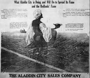
An advertisement showing the layout plans for Aladdin City, Florida, from the Homestead Leader
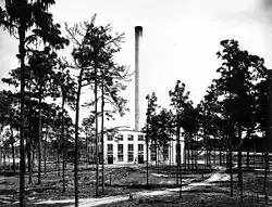
The power plant in Brewster, Florida, 1920
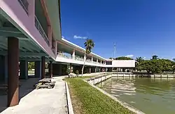
The visitor's center for Flamingo, Florida
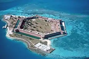
Fort Jefferson, Florida is a massive but unfinished coastal fortress. It is the largest masonry structure in the Americas,[1][2] and is composed of over 16 million bricks. The fort is located on Garden Key in the lower Florida Keys within the Dry Tortugas National Park, about 70 miles (110 km) west of the island of Key West.
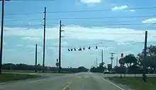
The intersection of SR 674/CR 39 at Fort Lonesome, Florida
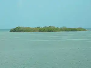
Indian Key, Florida, now uninhabited
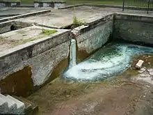
Site of the old Hampton Springs Hotel at Hampton Springs, Florida[3]
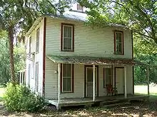
The former post office at Kerr City, Florida
Notes and references
- National Park Service Dry Tortugas National Park
- Trips: Florida’s Dry Tortugas National Park
- The Hampton Springs Hotel was built in 1908 and was destroyed by fire in 1954. The hotel was world-renowned for its sulphur springs and baths known for their healing and medicinal powers. The luxurious hotel boasted lush gardens with elaborate fountains and planters. The resort had a covered pool with foot baths fed by the springs, a golf course, tennis courts, stables, casino, grand ballroom, outdoor dance pavilion, and railroad depot. The nine-hole golf course was among the first in the region. The hotel had its own bottling plant and shipped the healing sulphur water nationwide. It also had its own power plant and the majority of the food served in the dining room was grown and raised at the hotel farm. The hotel had a private hunting and fishing lodge on Spring Creek six miles from the hotel site and an excursion boat with a covered launch. From the mid 1930s to mid 40s the hotel served as barracks for military personnel testing aircraft at Perry-Foley Airport in nearby Perry. Archaeological excavations here revealed the formation of the hotel and outbuildings. (Read more at the entry for Hampton Springs Hotel at The Historical Marker Database: Link)
- Craig Key
External links
This article is issued from Wikipedia. The text is licensed under Creative Commons - Attribution - Sharealike. Additional terms may apply for the media files.