Hendry County, Florida
Hendry County is a county located in the U.S. state of Florida. As of the 2010 census, the population was 39,140.[1] Its county seat is LaBelle.[2]
Hendry County | |
|---|---|
| Hendry County | |
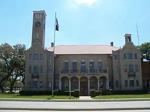 The Hendry County Courthouse at LaBelle in 2010. | |
 Seal | |
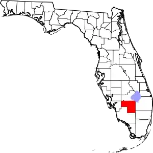 Location within the U.S. state of Florida | |
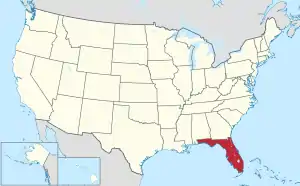 Florida's location within the U.S. | |
| Coordinates: 26°33′N 81°10′W | |
| Country | |
| State | |
| Founded | May 11, 1923 |
| Named for | Francis A. Hendry |
| Seat | LaBelle |
| Largest city | Clewiston |
| Area | |
| • Total | 1,190 sq mi (3,100 km2) |
| • Land | 1,153 sq mi (2,990 km2) |
| • Water | 37 sq mi (100 km2) 3.1%% |
| Population | |
| • Estimate (2019) | 42,022 |
| • Density | 34/sq mi (13/km2) |
| Time zone | UTC−5 (Eastern) |
| • Summer (DST) | UTC−4 (EDT) |
| Congressional district | 25th |
| Website | www |
Hendry County comprises the Clewiston, Micropolitan Statistical Area.
History
Hendry County was created in 1923. It was named for Captain Francis A. Hendry, a Florida cattle rancher, politician, and officer in the Confederate States Army during the American Civil War.
Geography
According to the U.S. Census Bureau, the county has a total area of 1,190 square miles (3,100 km2), of which 1,153 square miles (2,990 km2) is land and 37 square miles (96 km2) (3.1%) is water.[3] The county borders Lake Okeechobee; the Lake Okeechobee Scenic Trail runs through Hendry County.
Adjacent counties
- Glades County - north
- Martin County - northeast
- Okeechobee County -
northeast point in the middle of Lake Okeechobee - Palm Beach County - east
- Broward County - southeast
- Collier County - south
- Lee County - west
- Charlotte County - west
Demographics
| Historical population | |||
|---|---|---|---|
| Census | Pop. | %± | |
| 1930 | 3,492 | — | |
| 1940 | 5,237 | 50.0% | |
| 1950 | 6,051 | 15.5% | |
| 1960 | 8,119 | 34.2% | |
| 1970 | 11,859 | 46.1% | |
| 1980 | 18,599 | 56.8% | |
| 1990 | 25,773 | 38.6% | |
| 2000 | 36,210 | 40.5% | |
| 2010 | 39,140 | 8.1% | |
| 2019 (est.) | 42,022 | [4] | 7.4% |
| U.S. Decennial Census[5] 1790-1960[6] 1900-1990[7] 1990-2000[8] 2010-2019[1] | |||
As of the census[9] of 2000, there were 36,210 people, 10,850 households, and 8,137 families residing in the county. The population density was 31 people per square mile (12/km2). There were 12,294 housing units at an average density of 11 per square mile (4/km2). The racial makeup of the county was 66.08% White, 14.75% Black or African American, 0.80% Native American, 0.45% Asian, 0.03% Pacific Islander, 14.67% from other races, and 3.22% from two or more races. 39.59% of the population were Hispanic or Latino of any race.
In 2000 there were 10,850 households, out of which 40.2% had children under the age of 18 living with them, 55.7% were married couples living together, 12.5% had a female householder with no husband present, and 25.0% were non-families. 18.6% of all households were made up of individuals, and 7.3% had someone living alone who was 65 years of age or older. The average household size was 3.09 and the average family size was 3.44.
In the county, the population was spread out, with 30.0% under the age of 18, 13.3% from 18 to 24, 28.3% from 25 to 44, 18.3% from 45 to 64, and 10.1% who were 65 years of age or older. The median age was 30 years. For every 100 females, there were 125.0 males. For every 100 females age 18 and over, there were 131.4 males.
The median income for a household in the county was $33,592, and the median income for a family was $34,902. Males had a median income of $25,896 versus $20,070 for females. The per capita income for the county was $13,663. About 16.9% of families and 24.1% of the population were below the poverty line, including 29.9% of those under age 18 and 15.0% of those age 65 or over.
2010 Census
In 2010 the population of Hendry Country was 39,140. The racial and ethnic composition of the population was 34.9% non-Hispanic white, 13.4% black or African American, 1.7% Native American, 0.7% Asian, 0.1% Pacific Islander, 0.1% non-Hispanic reporting some other race, 2.7% reporting two or more races and 49.2% Hispanic or Latino.[10]
Politics
| Year | Republican | Democratic | Other |
|---|---|---|---|
| 2020 | 61.02% 7,906 | 38.04% 4,929 | 0.93% 121 |
| 2016 | 55.40% 6,195 | 41.27% 4,615 | 3.33% 372 |
| 2012 | 52.42% 5,355 | 46.51% 4,751 | 1.07% 109 |
| 2008 | 52.94% 5,780 | 45.78% 4,998 | 1.27% 139 |
| 2004 | 58.90% 5,757 | 40.51% 3,960 | 0.59% 58 |
| 2000 | 58.32% 4,747 | 39.81% 3,240 | 1.87% 152 |
| 1996 | 43.32% 3,855 | 43.66% 3,885 | 13.02% 1,159 |
| 1992 | 40.91% 3,279 | 33.57% 2,691 | 25.52% 2,046 |
| 1988 | 65.70% 3,965 | 33.74% 2,036 | 0.56% 34 |
| 1984 | 69.15% 4,524 | 30.85% 2,018 | |
| 1980 | 49.93% 2,703 | 46.97% 2,543 | 3.10% 168 |
| 1976 | 43.32% 1,843 | 54.94% 2,337 | 1.74% 74 |
| 1972 | 78.85% 2,763 | 21.09% 739 | 0.06% 2 |
| 1968 | 27.04% 900 | 23.76% 791 | 49.20% 1,638 |
| 1964 | 54.96% 1,650 | 45.04% 1,352 | |
| 1960 | 44.38% 1,043 | 55.62% 1,307 | |
| 1956 | 51.64% 1,071 | 48.36% 1,003 | |
| 1952 | 46.60% 918 | 53.40% 1,052 | |
| 1948 | 26.21% 340 | 53.89% 699 | 19.89% 258 |
| 1944 | 27.11% 347 | 72.89% 933 | |
| 1940 | 23.36% 317 | 76.64% 1,040 | |
| 1936 | 24.00% 234 | 76.00% 741 | |
| 1932 | 19.27% 163 | 80.73% 683 | |
| 1928 | 54.18% 337 | 42.77% 266 | 3.05% 19 |
| 1924 | 12.21% 21 | 76.74% 132 | 11.05% 19 |
Libraries
The Clewiston Public Library in Clewiston, the Harlem Library, also in Clewiston and the Barron Library in Labelle, all make up the Hendry County Library Cooperative.
The Clewiston Public Library, now known as the Harry T. Vaughn Library, came about in 1941 when the Mayor at the time, asked the Garden Club to organize a library. They enlisted the help of a librarian from the Moore Haven High School, a Miss Hazel Humble, who, with the help of two others, cataloged all the books over the course of their weekends for three months and then prepared to open the library to the public. In 1967 the library moved to its permanent location and in 1992 it was added to through funding from state and federal grants, the City of Lewiston, Hendry County, $100,000 from US Sugar and $57,510 from private donations.[12][13]
The mission of the cooperative, as taken from their website, is this: The mission of the Hendry County Library Cooperative is to provide its citizens with access to materials and information for work, school, and personal life that are both educational and entertaining. The goals (documented in the Annual Plan of Service) are to provide up-to-date resources, including electronic media, to meet their information needs at the Cooperative Libraries; to develop specialty areas to better serve all our patrons; to enable residents to have access to increased materials reflecting current topics and titles; to provide students of all ages with access to educational materials; to take steps towards serving as information and community referral centers; and to ensure residents have access to up-to-date resources in all formats.[12]
Archaeology
Transportation
Fictional references
- In Carl Hiaasen's novel Skinny Dip, agribusiness executive "Red" Hammernut has his offices in LaBelle, and owns significant areas of farmland in Hendry County.
- A scene from Just Cause (film), a 1995 suspense crime thriller film directed by Arne Glimcher and starring Sean Connery and Laurence Fishburne, was filmed in Fort Denaud, Florida.
References
- "State & County QuickFacts". United States Census Bureau. Retrieved February 14, 2014.
- "Find a County". National Association of Counties. Archived from the original on 2011-05-31. Retrieved 2011-06-07.
- "US Gazetteer files: 2010, 2000, and 1990". United States Census Bureau. 2011-02-12. Retrieved 2011-04-23.
- "Population and Housing Unit Estimates". Retrieved May 21, 2020.
- "U.S. Decennial Census". United States Census Bureau. Retrieved June 14, 2014.
- "Historical Census Browser". University of Virginia Library. Retrieved June 14, 2014.
- "Population of Counties by Decennial Census: 1900 to 1990". United States Census Bureau. Retrieved June 14, 2014.
- "Census 2000 PHC-T-4. Ranking Tables for Counties: 1990 and 2000" (PDF). United States Census Bureau. Retrieved June 14, 2014.
- "U.S. Census website". United States Census Bureau. Retrieved 2011-05-14.
- 2010 general demographic report for Hendry County
- Leip, David. "Dave Leip's Atlas of U.S. Presidential Elections". uselectionatlas.org. Retrieved 2018-06-15.
- http://hendrylibraries.org
- https://www.facebook.com/clewistonpubliclibrary/
External links
| Wikimedia Commons has media related to Hendry County, Florida. |
Government links/constitutional offices
Special districts
Judicial branch
Tourism links
- Hendry County Tourism Archived 2004-12-03 at the Wayback Machine
Museum and Library Resources
- The Caloosa Belle, the local newspaper for Hendry County, Florida fully and openly available in the Florida Digital Newspaper Library
Places adjacent to Hendry County, Florida | ||||||||||
|---|---|---|---|---|---|---|---|---|---|---|
| ||||||||||
Municipalities and communities of Hendry County, Florida, United States | ||
|---|---|---|
| Cities | | |
| CDPs | ||
| Indian reservation | ||
| Unincorporated community | ||
| Footnotes | ‡This populated place also has portions in an adjacent county or counties | |
| ||
| Authority control |
|---|