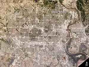
Omaha–Council Bluffs metropolitan area
The Omaha metropolitan area, officially known as the Omaha-Council Bluffs, NE-IA Metropolitan Statistical Area (MSA), is an urbanized region centered on the city of Omaha, Nebraska. The region extends over a large area on both sides of the Missouri River in Nebraska and Iowa, in the American Midwest. The Omaha metropolitan area is the largest in Nebraska and is the 57th largest in the United States, with an estimated population of 1,058,125 (2020).[1] As defined by the Office of Management and Budget, it consists of eight counties—five in Nebraska and three in Iowa.[2][3] The region is locally referred to as "Big O", "the Metro Area", "the Metro", or simply "Omaha". The core counties of Douglas and Sarpy in Nebraska and Pottawattamie in Iowa contain large urbanized areas; the other five counties consist primarily of rural communities. The larger Omaha-Council Bluffs-Fremont, NE-IA Combined Statistical Area (CSA) encompasses the Omaha-Council Bluffs MSA as well as the separate Fremont, NE Micropolitan Statistical Area, which consists of the entirety of Dodge County, Nebraska.
Omaha Metro | |
|---|---|
| Omaha-Council Bluffs, NE-IA Metropolitan Statistical Area | |
 | |
| Coordinates: 41°15′35″N 95°55′18″W | |
| Country | United States |
| State(s) | |
| Largest city | Omaha |
| Other cities | |
| Area | |
| • Total | 4,407 sq mi (11,410 km2) |
| Population (2019 estimate) | |
| • Total | 1,058,125 |
| • Rank | 59th in the U.S. |
| • Density | 213.8/sq mi (133/km2) |
Historical definitions and populations
| Historical population | |||
|---|---|---|---|
| Census | Pop. | %± | |
| 1950 | 366,395 | — | |
| 1960 | 457,873 | 25.0% | |
| 1970 | 540,142 | 18.0% | |
| 1980 | 589,857 | 9.2% | |
| 1990 | 678,262 | 15.0% | |
| 2000 | 867,041 | 27.8% | |
| 2010 | 965,350 | 11.3% | |
| [4] | |||
Standard definitions for United States metropolitan areas were created in 1949; the first census which had metropolitan area data was the 1950 census. At that time, the Omaha–Council Bluffs metropolitan area comprised three counties: Douglas and Sarpy in Nebraska, and Pottawattamie in Iowa. No additional counties were added to the metropolitan area until 1983, when Washington County, Nebraska was added. Cass County, Nebraska was added in 1993; Saunders County in Nebraska and Harrison and Mills counties in Iowa became part of the Omaha–Council Bluffs metropolitan area in 2003.
The 2003 revision to metropolitan area definitions was accompanied by the creation of micropolitan areas and Combined Statistical Areas. Fremont, in Dodge County, Nebraska, was designated a micropolitan area. The Omaha–Council Bluffs–Fremont combined statistical area has a population of 1,058,125 (2020 estimate).[5]
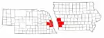
Components of the Omaha–Council Bluffs metropolitan area
Counties
| County | State | 2018 estimate | 2010 Census | Change |
|---|---|---|---|---|
| Cass | Nebraska | 26,159 | 25,241 | +3.64%[6] |
| Douglas | Nebraska | 566,880 | 517,110 | +9.62%[6] |
| Sarpy | Nebraska | 184,459 | 158,840 | +16.13%[6] |
| Saunders | Nebraska | 21,303 | 20,780 | +2.52%[6] |
| Washington | Nebraska | 20,667 | 20,234 | +2.14%[6] |
| Harrison | Iowa | 14,134 | 14,937 | −5.38%[7] |
| Mills | Iowa | 15,063 | 15,059 | +0.03%[7] |
| Pottawattamie | Iowa | 93,533 | 93,158 | +0.40%[7] |

Cities of 10,000 people or more
- Council Bluffs, Iowa - 62,421 inhabitants (2018)
- Bellevue, Nebraska – 53,627 inhabitants (2018)
- La Vista, Nebraska – 23,637 inhabitants (2018)
- Papillion, Nebraska – 20,530 inhabitants (2018)
Cities of 5,000 to 10,000 people
- Blair, Nebraska – 7,990 inhabitants
- Glenwood, Iowa – 5,269 inhabitants
- Plattsmouth, Nebraska – 6,502 inhabitants
- Ralston, Nebraska – 7,187 inhabitants
Cities of 1,000 to 5,000 people
|
|
Cities and villages with fewer than 1,000 people
|
|
Census-designated places
- Chalco, Nebraska – 10,736 inhabitants
- Offutt Air Force Base – 8,901 inhabitants
Annexations of formerly incorporated places by the City of Omaha
| Annexations by the City of Omaha | |||||
|---|---|---|---|---|---|
| Year | Former incorporated area name | ||||
| 1854 | East Omaha, Nebraska | ||||
| 1877 | Kountze Place | ||||
| 1877 | Gifford Park | ||||
| 1877 | Saratoga, Nebraska | ||||
| 1877 | Near North Side, Omaha | ||||
| 1887 | Sheelytown | ||||
| 1887 | Bemis Park | ||||
| 1915 | South Omaha, Nebraska | ||||
| 1915 | Dundee, Nebraska | ||||
| 1917 | Benson, Nebraska | ||||
| 1917 | Florence, Nebraska | ||||
| 1971 | Millard, Nebraska | ||||
| 2005 | Elkhorn, Nebraska | ||||
Notes
- "Table 1. Annual Estimates of the Population of Combined Statistical Ar/s: April 1, 2010 to July 1, 2017 (CBSA-EST2012-02)" (CSV). 2017 Population Estimates. United States Census Bureau, Population Division. July 1, 2017. Retrieved January 9, 2019.
- Hunzeker, S. "Nebraska Metro & Micro Statistical Areas" Archived January 7, 2009, at the Wayback Machine, Nebraska Department of Labor. Retrieved September 5, 2008.
- "May 2007 OES Metropolitan and Nonmetropolitan Area Definitions." Bureau of Labor Statistics. Retrieved September 5, 2008.
- "Metro population hits 965,350". Omaha World-Herald. March 1, 2011. Retrieved March 6, 2011.
- Iowa Data Center. "Population Estimates and Components of Population Change for Iowa's Combined Statistical Areas (2003 Definition): 2000–2006" (PDF). Retrieved April 6, 2007.
- "U.S. Census Bureau QuickFacts: Washington County, Nebraska; Sarpy County, Nebraska; Saunders County, Nebraska; Douglas County, Nebraska; Cass County, Nebraska". Census Bureau QuickFacts.
- "U.S. Census Bureau QuickFacts: Harrison County, Iowa; Pottawattamie County, Iowa; Mills County, Iowa". Census Bureau QuickFacts.
External links
- Population for Iowa metropolitan areas and components, 1950 – 2000
- omaha.towncommons.com – wiki website for the Omaha–Council Bluffs metro area
| Topics |  | |
|---|---|---|
| Geography | ||
| History | ||
| Government | ||
| Education | ||
| People |
| |
| ||
Metropolitan area of Omaha–Council Bluffs | ||||||
|---|---|---|---|---|---|---|
| Primary cities |
|  | ||||
| Cities over 10,000 (per 2010 Census) |
| |||||
| Cities of 5,000 to 10,000 (per 2010 Census) |
| |||||
| Cities of 1,000 to 5,000 (per 2010 Census) |
| |||||
| Census-designated places |
| |||||
| Cities and villages of fewer than 1,000 (per 2010 Census) |
| |||||
| Counties |
| |||||

