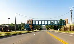
La Vista, Nebraska
La Vista is a city in Sarpy County, Nebraska, United States. The population was 15,758 at the 2010 census. The city was incorporated on February 23, 1960.
La Vista, Nebraska | |
|---|---|
 | |
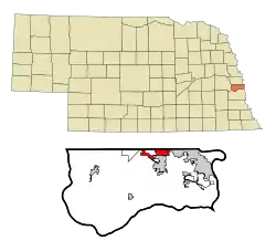 Location of La Vista within Nebraska and Sarpy County | |
| Coordinates: 41°11′4″N 96°2′22″W | |
| Country | United States |
| State | Nebraska |
| County | Sarpy |
| Area | |
| • Total | 5.43 sq mi (14.07 km2) |
| • Land | 5.43 sq mi (14.06 km2) |
| • Water | 0.00 sq mi (0.01 km2) |
| Elevation | 1,109 ft (338 m) |
| Population | |
| • Total | 15,758 |
| • Estimate (2019)[3] | 17,170 |
| • Density | 3,162.06/sq mi (1,220.89/km2) |
| Time zone | UTC-6 (Central (CST)) |
| • Summer (DST) | UTC-5 (CDT) |
| ZIP code | 68128 |
| Area code(s) | 402 |
| FIPS code | 31-26385 |
| GNIS feature ID | 0830573[4] |
| Website | http://cityoflavista.org/ |
La Vista is a suburb of Omaha. It is bordered by the cities of Omaha and Ralston on the north, Papillion on the south, Bellevue on the east, and Interstate 80 to the west. La Vista is Sarpy County's third largest city, after Bellevue and Papillion, the county seat.
History
La Vista got its start in the year 1959, when it was built up by a property developer.[5]
Geography
La Vista is located at 41°11′4″N 96°2′22″W (41.184344, -96.039441).[6]
According to the United States Census Bureau, the city has a total area of 4.28 square miles (11.09 km2), all land.[7]
The nearest hospital is Midlands Hospital (3.4 miles distant), located in Papillion. Papillion is also the location of the county courthouse.
Demographics
| Historical population | |||
|---|---|---|---|
| Census | Pop. | %± | |
| 1970 | 4,858 | — | |
| 1980 | 9,588 | 97.4% | |
| 1990 | 9,840 | 2.6% | |
| 2000 | 11,699 | 18.9% | |
| 2010 | 15,758 | 34.7% | |
| 2019 (est.) | 17,170 | [3] | 9.0% |
| U.S. Decennial Census[8] | |||
2010 census
At the 2010 census there were 15,758 people, 6,419 households, and 4,058 families living in the city. The population density was 3,681.8 inhabitants per square mile (1,421.6/km2). There were 6,670 housing units at an average density of 1,558.4 per square mile (601.7/km2). The racial makeup of the city was 86.9% White, 3.9% African American, 0.4% Native American, 3.2% Asian, 0.1% Pacific Islander, 2.6% from other races, and 2.8% from two or more races. Hispanic or Latino of any race were 6.5%.[2]
Of the 6,419 households 34.5% had children under the age of 18 living with them, 45.7% were married couples living together, 12.9% had a female householder with no husband present, 4.6% had a male householder with no wife present, and 36.8% were non-families. 28.7% of households were one person and 5.1% were one person aged 65 or older. The average household size was 2.45 and the average family size was 3.06.
The median age was 32.1 years. 25.9% of residents were under the age of 18; 10.3% were between the ages of 18 and 24; 31.7% were from 25 to 44; 24.6% were from 45 to 64; and 7.5% were 65 or older. The gender makeup of the city was 48.3% male and 51.7% female.
2000 census
At the 2000 census, there were 11,699 people, 4,404 households, and 3,131 families living in the city. The population density was 4,114.8 people per square mile (1,590.5/km2). There were 4,511 housing units at an average density of 1,586.6/sq mi (613.3/km2). The racial makeup of the city was 90.45% White, 2.94% African American, 0.39% Native American, 2.35% Asian, 0.10% Pacific Islander, 1.62% from other races, and 2.14% from two or more races. Hispanic or Latino of any race were 4.15% of the population.
Of the 4,404 households 40.0% had children under the age of 18 living with them, 52.5% were married couples living together, 14.9% had a female householder with no husband present, and 28.9% were non-families. 21.4% of households were one person and 3.3% were one person aged 65 or older. The average household size was 2.66 and the average family size was 3.13.
The age distribution was 29.8% under the age of 18, 10.4% from 18 to 24, 36.4% from 25 to 44, 18.9% from 45 to 64, and 4.5% 65 or older. The median age was 30 years. For every 100 females, there were 94.6 males. For every 100 females age 18 and over, there were 89.6 males.
The median household income was $47,280, and the median family income was $52,819. Males had a median income of $34,732 versus $25,076 for females. The per capita income for the city was $19,612. About 4.4% of families and 5.7% of the population were below the poverty line, including 7.9% of those under age 18 and 3.1% of those age 65 or over.
Schools
La Vista falls within the Papillion-La Vista Public School system.[9]
Elementary schools
(Grades K-6)
- Portal Elementary, 9920 Brentwood Drive
- Parkview Heights Elementary, 7609 South 89th Street
- La Vista West Elementary, 7821 Terry Drive
- G. Stanley Hall Elementary, 7600 South 72nd Street
Middle school
Grades 7-8 La Vista Junior High is located at 7900 Edgewood Blvd
References
- "2019 U.S. Gazetteer Files". United States Census Bureau. Retrieved July 26, 2020.
- "U.S. Census website". United States Census Bureau. Retrieved 2012-06-24.
- "Population and Housing Unit Estimates". United States Census Bureau. May 24, 2020. Retrieved May 27, 2020.
- "US Board on Geographic Names". United States Geological Survey. 2007-10-25. Retrieved 2008-01-31.
- "La Vista, Sarpy County". Center for Advanced Land Management Information Technologies. University of Nebraska. Retrieved 23 August 2014.
- "US Gazetteer files: 2010, 2000, and 1990". United States Census Bureau. 2011-02-12. Retrieved 2011-04-23.
- "US Gazetteer files 2010". United States Census Bureau. Archived from the original on 2012-01-25. Retrieved 2012-06-24.
- United States Census Bureau. "Census of Population and Housing". Retrieved June 19, 2013.
- http://www.paplv.esu3.org/index.cfm?action=202&bt=8,18&bt1=47&id=449
External links
| Wikimedia Commons has media related to La Vista, Nebraska. |
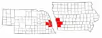
Municipalities and communities of Sarpy County, Nebraska, United States | ||
|---|---|---|
| Cities | Map of Nebraska highlighting Sarpy County | |
| CDPs | ||
| Other unincorporated communities | ||
| ||
Metropolitan area of Omaha–Council Bluffs | ||||||
|---|---|---|---|---|---|---|
| Primary cities |
|  | ||||
| Cities over 10,000 (per 2010 Census) |
| |||||
| Cities of 5,000 to 10,000 (per 2010 Census) |
| |||||
| Cities of 1,000 to 5,000 (per 2010 Census) |
| |||||
| Census-designated places |
| |||||
| Cities and villages of fewer than 1,000 (per 2010 Census) |
| |||||
| Counties |
| |||||

| Authority control |
|---|