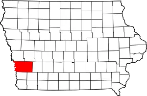
Pottawattamie County, Iowa
Pottawattamie County (/ˌpɑːtəˈwɑːtəmiː/) is located in the U.S. state of Iowa. At the 2010 census, the population was 93,158.[1] The county takes its name from the Potawatomi Native American tribe. The county seat is Council Bluffs.[2][3]
Pottawattamie County | |
|---|---|
 | |
 Location within the U.S. state of Iowa | |
 Iowa's location within the U.S. | |
| Coordinates: 41°20′N 95°32′W | |
| Country | |
| State | |
| Founded | September 21, 1848 |
| Named for | Potawatomi tribe |
| Seat | Council Bluffs |
| Largest city | Council Bluffs |
| Area | |
| • Total | 959 sq mi (2,480 km2) |
| • Land | 950 sq mi (2,500 km2) |
| • Water | 8.9 sq mi (23 km2) 0% |
| Population (2010) | |
| • Total | 93,158 |
| • Estimate (2018) | 93,533 |
| • Density | 97/sq mi (38/km2) |
| Time zone | UTC−6 (Central) |
| • Summer (DST) | UTC−5 (CDT) |
| Congressional district | 3rd |
| Website | www |
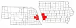
Pottawattamie County is included in the Omaha–Council Bluffs, NE–IA Metropolitan Statistical Area.[4]
Geography
According to the U.S. Census Bureau, the county has a total area of 959 square miles (2,480 km2), of which 950 square miles (2,500 km2) is land and 8.9 square miles (23 km2) (0.9%) is water.[5] It is the second-largest county in Iowa by area after Kossuth County.[6]
Due to movement of the Missouri River and a Supreme Court ruling, part of the county, Carter Lake, actually lies on the far side of the Missouri River. This part of the county cannot be reached by road without entering Nebraska; no direct bridge exists.[7]
Major highways
 Interstate 29
 Interstate 80
.svg.png.webp) Interstate 480
Interstate 480.svg.png.webp) Interstate 680
Interstate 680.svg.png.webp) Interstate 880
Interstate 880 U.S. Highway 6
 U.S. Highway 59
.svg.png.webp) U.S. Highway 275
U.S. Highway 275 Iowa Highway 83
 Iowa Highway 92
 Iowa Highway 165
 Iowa Highway 191
 Iowa Highway 192
Adjacent counties
- Harrison County (north)
- Shelby County (northeast)
- Cass County (east)
- Montgomery County (southeast)
- Mills County (south)
- Sarpy County, Nebraska (southwest)
- Douglas County, Nebraska (west)
- Washington County, Nebraska (northwest)
National protected area
Demographics
| Historical population | |||
|---|---|---|---|
| Census | Pop. | %± | |
| 1850 | 7,828 | — | |
| 1860 | 4,968 | −36.5% | |
| 1870 | 16,893 | 240.0% | |
| 1880 | 39,850 | 135.9% | |
| 1890 | 47,430 | 19.0% | |
| 1900 | 54,336 | 14.6% | |
| 1910 | 55,832 | 2.8% | |
| 1920 | 61,550 | 10.2% | |
| 1930 | 69,888 | 13.5% | |
| 1940 | 66,756 | −4.5% | |
| 1950 | 69,682 | 4.4% | |
| 1960 | 83,102 | 19.3% | |
| 1970 | 86,991 | 4.7% | |
| 1980 | 86,561 | −0.5% | |
| 1990 | 82,628 | −4.5% | |
| 2000 | 87,704 | 6.1% | |
| 2010 | 93,158 | 6.2% | |
| 2018 (est.) | 93,533 | [8] | 0.4% |
| U.S. Decennial Census[9] 1790-1960[10] 1900-1990[11] 1990-2000[12] 2010-2018[1] | |||
2010 census
The 2010 census recorded a population of 93,158 in the county, with a population density of 97.6233/sq mi (37.6926/km2). There were 39,330 housing units, of which 36,775 were occupied.[13]
2000 census
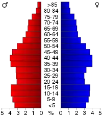
At the 2000 census,[14] there were 87,704 people, 33,844 households and 23,623 families residing in the county. The population density was 92 per square mile (35/km2). There were 35,761 housing units at an average density of 38 per square mile (14/km2). The racial makeup of the county was 95.98% White, 0.77% Black or African American, 0.37% Native American, 0.48% Asian, 0.02% Pacific Islander, 1.27% from other races, and 1.11% from two or more races. 3.30% of the population were Hispanic or Latino of any race.
There were 33,844 households, of which 32.30% had children under the age of 18 living with them, 53.60% were married couples living together, 11.80% had a female householder with no husband present and 30.20% were non-families. 24.90% of all households were made up of individuals, and 10.00% had someone living alone who was 65 years of age or older. The average household size was 2.54 and the average family size was 3.03.
26.00% of the population were under the age of 18, 9.10% from 18 to 24, 28.60% from 25 to 44, 22.70% from 45 to 64, and 13.70% who were 65 years of age or older. The median age was 36 years. For every 100 females there were 95.50 males. For every 100 females age 18 and over, there were 92.60 males.
The median household income was $40,089 and the median family income was $47,105. Males had a median income of $31,642 vand females $24,243. The per capita income was $19,275. About 6.40% of families and 8.40% of the population were below the poverty line, including 11.00% of those under age 18 and 6.30% of those age 65 or over.
Communities
Cities
Unincorporated community
Townships
Population ranking
The population ranking of the following table is based on the 2010 census of Pottawattamie County.[15]
† county seat
| Rank | City/Town/etc. | Municipal type | Population (2010 Census) |
|---|---|---|---|
| 1 | † Council Bluffs | City | 62,230 |
| 2 | Carter Lake | City | 3,785 |
| 3 | Oakland | City | 1,527 |
| 4 | Avoca | City | 1,506 |
| 5 | Treynor | City | 919 |
| 6 | Underwood | City | 917 |
| 7 | Neola | City | 842 |
| 8 | Carson | City | 812 |
| 9 | Walnut | City | 785 |
| 10 | Crescent | City | 617 |
| 11 | Minden | City | 599 |
| 12 | Macedonia | City | 246 |
| 13 | Hancock | City | 196 |
| 14 | McClelland | City | 151 |
| 15 | Bentley | CDP | 118 |
| 16 | Weston | CDP | 92 |
| 17 | Loveland | CDP | 35 |
| 18 | Shelby (partially in Shelby County) | City | 23 (641 total) |
Law enforcement
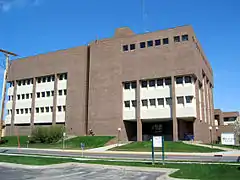
Pottawattamie County is served by the Pottawattamie County Sheriff's Office consisting of 51 sworn deputies, 13 reserve deputies, 92 detention officers and eight civilian support staff. Its headquarters is located in Council Bluffs, Iowa.[16]
Politics
Pottawattamie County is a strongly Republican county. The county last backed a Democratic presidential candidate in 1964 as the party won nationally by a landslide, & only voted Democratic in four other elections prior to that. Some recent elections were more competitive, with Barack Obama losing the county in 2008 by less than 1,000 votes. However, Donald Trump won the county by 21% in 2016 and by 17% in 2020.
| Year | Republican | Democratic | Third Parties |
|---|---|---|---|
| 2020 | 57.4% 26,247 | 40.6% 18,575 | 2.0% 922 |
| 2016 | 57.3% 24,447 | 36.0% 15,355 | 6.7% 2,878 |
| 2012 | 51.7% 21,860 | 46.4% 19,644 | 1.9% 797 |
| 2008 | 50.2% 21,237 | 48.3% 20,436 | 1.5% 651 |
| 2004 | 58.7% 24,558 | 40.4% 16,906 | 0.9% 356 |
| 2000 | 54.5% 18,783 | 42.7% 14,726 | 2.8% 958 |
| 1996 | 47.7% 15,648 | 40.5% 13,276 | 11.9% 3,897 |
| 1992 | 42.2% 15,671 | 35.6% 13,228 | 22.1% 8,216 |
| 1988 | 53.1% 17,193 | 46.2% 14,958 | 0.8% 254 |
| 1984 | 63.1% 21,527 | 36.1% 12,329 | 0.8% 256 |
| 1980 | 61.0% 20,222 | 32.3% 10,709 | 6.8% 2,239 |
| 1976 | 53.1% 17,264 | 45.4% 14,754 | 1.5% 501 |
| 1972 | 69.3% 19,722 | 28.4% 8,074 | 2.3% 654 |
| 1968 | 56.5% 16,038 | 33.4% 9,495 | 10.1% 2,866 |
| 1964 | 44.7% 14,208 | 55.3% 17,569 | 0.1% 22 |
| 1960 | 57.8% 19,223 | 42.2% 14,025 | 0.0% 13 |
| 1956 | 57.9% 17,632 | 41.8% 12,731 | 0.3% 105 |
| 1952 | 61.2% 18,894 | 38.6% 11,897 | 0.2% 63 |
| 1948 | 51.4% 12,384 | 47.4% 11,430 | 1.2% 281 |
| 1944 | 54.3% 14,007 | 45.5% 11,752 | 0.2% 59 |
| 1940 | 51.1% 15,929 | 48.8% 15,221 | 0.1% 38 |
| 1936 | 42.3% 12,223 | 56.2% 16,259 | 1.5% 431 |
| 1932 | 35.9% 9,565 | 62.7% 16,674 | 1.4% 377 |
| 1928 | 58.9% 14,354 | 40.7% 9,905 | 0.5% 109 |
| 1924 | 52.8% 13,380 | 20.9% 5,305 | 26.3% 6,667 |
| 1920 | 64.7% 13,506 | 31.9% 6,659 | 3.5% 722 |
| 1916 | 47.8% 5,992 | 50.0% 6,263 | 2.2% 274 |
| 1912 | 14.8% 1,753 | 42.1% 4,993 | 43.1% 5,120[lower-alpha 1] |
| 1908 | 51.2% 6,137 | 46.0% 5,520 | 2.8% 338 |
| 1904 | 61.1% 6,868 | 33.2% 3,731 | 5.6% 634 |
| 1900 | 54.1% 6,525 | 44.6% 5,373 | 1.3% 154 |
| 1896 | 51.0% 5,810 | 48.0% 5,468 | 1.0% 114 |
Notes
- The leading “other” candidate, Progressive Theodore Roosevelt, received 4,538 votes, while Socialist candidate Eugene Debs received 489 votes, Prohibition candidate Eugene Chafin received 93 votes.
References
- "State & County QuickFacts". United States Census Bureau. Archived from the original on July 17, 2011. Retrieved July 20, 2014.
- Pottawattamie County, Iowa Archived May 27, 2009, at the Wayback Machine, Pottawattamie County, 2007. Retrieved September 5, 2007.
- "Find a County". National Association of Counties. Retrieved June 7, 2011.
- United States Office of Management and Budget. "Update of Statistical Area Definitions and Guidance on Their Uses" (PDF). pp. 5, 36. Archived from the original (PDF) on May 14, 2006. Retrieved July 21, 2006.
- "US Gazetteer files: 2010, 2000, and 1990". United States Census Bureau. February 12, 2011. Retrieved April 23, 2011.
- National Association of Counties. "NACo - Find a county". Archived from the original on 2005-04-10. Retrieved 2008-04-30.
- "A History of Carter Lake". Adam Fletcher Sasse. 2013-09-28. Retrieved 2020-09-14.
- "Population and Housing Unit Estimates". Retrieved June 15, 2019.
- "U.S. Decennial Census". United States Census Bureau. Retrieved July 20, 2014.
- "Historical Census Browser". University of Virginia Library. Retrieved July 20, 2014.
- "Population of Counties by Decennial Census: 1900 to 1990". United States Census Bureau. Retrieved July 20, 2014.
- "Census 2000 PHC-T-4. Ranking Tables for Counties: 1990 and 2000" (PDF). United States Census Bureau. Retrieved July 20, 2014.
- "Population & Housing Occupancy Status 2010". United States Census Bureau American FactFinder. Retrieved June 1, 2011.
- "U.S. Census website". United States Census Bureau. Retrieved January 31, 2008.
- https://www.census.gov/2010census/
- "Pottawattamie County Sheriff's Office". Retrieved May 2, 2016.
- Leip, David. "Dave Leip's Atlas of U.S. Presidential Elections". uselectionatlas.org. Retrieved 2020-11-14.
External links
| Wikimedia Commons has media related to Pottawattamie County, Iowa. |
Places adjacent to Pottawattamie County, Iowa | |
|---|---|
Municipalities and communities of Pottawattamie County, Iowa, United States | ||
|---|---|---|
| Cities | Map of Iowa highlighting Pottawattamie County | |
| Townships | ||
| CDPs | ||
| Other community | ||
| Footnotes | ‡This populated place also has portions in an adjacent county or counties | |
| ||
Metropolitan area of Omaha–Council Bluffs | ||||||
|---|---|---|---|---|---|---|
| Primary cities |
|  | ||||
| Cities over 10,000 (per 2010 Census) |
| |||||
| Cities of 5,000 to 10,000 (per 2010 Census) |
| |||||
| Cities of 1,000 to 5,000 (per 2010 Census) |
| |||||
| Census-designated places |
| |||||
| Cities and villages of fewer than 1,000 (per 2010 Census) |
| |||||
| Counties |
| |||||

| Authority control |
|---|