Douglas County, Nebraska
Douglas County is a county located in the U.S. state of Nebraska. As of the 2010 United States Census, the population was 517,110.[1] It is the state's most populous county, home to over one-fourth of Nebraska's residents. Its county seat is Omaha,[2] the state's largest city. The county was established in 1854 and named after Stephen A. Douglas (1813–1861), Senator from Illinois.[3][4]
Douglas County | |
|---|---|
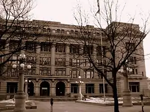 Douglas County Courthouse in Omaha | |
 Seal  Logo | |
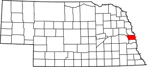 Location within the U.S. state of Nebraska | |
 Nebraska's location within the U.S. | |
| Coordinates: 41°18′N 96°09′W | |
| Country | |
| State | |
| Founded | 23 November 1854 |
| Named for | Stephen A. Douglas |
| Seat | Omaha |
| Largest city | Omaha |
| Area | |
| • Total | 339 sq mi (880 km2) |
| • Land | 328 sq mi (850 km2) |
| • Water | 11 sq mi (30 km2) 3.2%% |
| Population | |
| • Estimate (2019) | 571,327 |
| • Density | 1,728/sq mi (667/km2) |
| Time zone | UTC−6 (Central) |
| • Summer (DST) | UTC−5 (CDT) |
| Congressional district | 2nd |
| Website | www |
Douglas County is part of the Omaha-Council Bluffs, NE-IA Metropolitan Statistical Area.[5]
In the Nebraska license plate system, Douglas County was represented by the prefix "1" (as it had the largest number of vehicles registered in the county when the license plate system was established in 1922). In 2002, the state discontinued the 1922 system in the three most populous counties: Douglas, Lancaster, and Sarpy counties.[6]
Geography
Douglas County is on the east side of Nebraska. Its east boundary line abuts the west boundary line of the state of Iowa, across the Missouri River. The Elkhorn River runs southward through the west-central part of Douglas County, and it is bordered on east (Missouri River) and west (Platte River) by rivers. According to the U.S. Census Bureau, the county has a total area of 339 square miles (880 km2), of which 328 square miles (850 km2) is land and 11 square miles (28 km2) (3.2%) is water.[7]
Major highways
 Interstate 80
 Interstate 480
 Interstate 680
 U.S. Highway 6
 U.S. Highway 75
 U.S. Highway 275
 Nebraska Highway 31
 Nebraska Highway 36
 Nebraska Highway 50
 Nebraska Highway 64
 Nebraska Highway 85
 Nebraska Highway 92
 Nebraska Highway 133
Adjacent counties
- Dodge County – northwest
- Washington County – north
- Pottawattamie County, Iowa – east
- Sarpy County – south
- Saunders County – west
Demographics
| Historical population | |||
|---|---|---|---|
| Census | Pop. | %± | |
| 1860 | 4,328 | — | |
| 1870 | 19,982 | 361.7% | |
| 1880 | 37,645 | 88.4% | |
| 1890 | 158,008 | 319.7% | |
| 1900 | 140,590 | −11.0% | |
| 1910 | 168,546 | 19.9% | |
| 1920 | 204,524 | 21.3% | |
| 1930 | 232,982 | 13.9% | |
| 1940 | 247,562 | 6.3% | |
| 1950 | 281,020 | 13.5% | |
| 1960 | 343,490 | 22.2% | |
| 1970 | 389,455 | 13.4% | |
| 1980 | 397,038 | 1.9% | |
| 1990 | 416,444 | 4.9% | |
| 2000 | 463,585 | 11.3% | |
| 2010 | 517,110 | 11.5% | |
| 2019 (est.) | 571,327 | [10] | 10.5% |
| US Decennial Census[11] 1790-1960[12] 1900-1990[13] 1990-2000[14] 2010-2019[1] | |||
2010 census
As of the 2010 United States Census, there were 517,110 people and 206,522 households in the county. The population density was 1,574 people per square mile (978/km2). There were 219,580 housing units at an average density of 669 per square mile (415/km2). The racial makeup of the county was 76.4% White, 11.6% Black or African American, 0.7% Native American, 2.7% Asian, 0.1% Pacific Islander, 5.7% from some other race, and 2.8% from two or more races. 11.2% of the population were Hispanic or Latino of any race. 30% were of German, 15% Irish, 8.0% English, and 4.9% Italian ancestry.
The median income for a household in the county was $51,878, and the median income for a family was $67,666. Males had a median income of $44,542 versus $35,801 for females. The per capita income for the county was $28,092. About 9.4% of families and 13.1% of the population were below the poverty line, including 17.6% of those under age 18 and 8.0% of those age 65 or over.
2000 census
As of the 2000 United States Census, there were 463,585 people, 182,194 households, and 115,146 families in the county. The population density was 1,401 people per square mile (541/km2). There were 192,672 housing units at an average density of 582 per square mile (225/km2). The racial makeup of the county was 80.96% White, 11.50% Black or African American, 0.61% Native American, 1.71% Asian, 0.05% Pacific Islander, 3.40% from other races, and 1.76% from two or more races. 6.67% of the population were Hispanic or Latino of any race. 26.3% were of German, 11.5% Irish and 6.2% English ancestry.
There were 182,194 households, out of which 32.00% had children under the age of 18 living with them, 47.50% were married couples living together, 12.10% had a female householder with no husband present, and 36.80% were non-families. 29.80% of all households were made up of individuals, and 8.70% had someone living alone who was 65 years of age or older. The average household size was 2.48 and the average family size was 3.12.
The county population contained 26.60% under the age of 18, 10.30% from 18 to 24, 31.20% from 25 to 44, 21.00% from 45 to 64, and 11.00% who were 65 years of age or older. The median age was 34 years. For every 100 females there were 95.70 males. For every 100 females age 18 and over, there were 92.90 males.
The median income for a household in the county was $43,209, and the median income for a family was $54,651. Males had a median income of $36,577 versus $27,265 for females. The per capita income for the county was $22,879. About 6.70% of families and 9.80% of the population were below the poverty line, including 13.00% of those under age 18 and 7.20% of those age 65 or over.
Government
Douglas County is governed by a board of seven county commissioners, elected to staggered[15] four–year terms. County courthouse positions are also elected on a partisan basis. Most of the county's offices are located at the Douglas County Courthouse.
| District | Commissioner |
|---|---|
| 1 | Mike Boyle |
| 2 | James Cavanaugh |
| 3 | Chris Rodgers (Vice-chair)[16] |
| 4 | P.J. Morgan |
| 5 | Marc Kraft |
| 6 | Mary Ann Borgeson (Chair)[16] |
| 7 | Clare Duda |
| Office | Officeholder |
|---|---|
| Assessor/Register of Deeds | Diane Battiato[17] |
| County Attorney | Donald Kleine[18] |
| County Clerk/Comptroller | Dan Esch[19] |
| Clerk of the District Court | John Friend |
| County Engineer | Tom Doyle |
| County Sheriff | Tim Dunning |
| County Treasurer | John W. Ewing |
| Public Defender | Tom Riley |
For much of the time after World War II, Douglas County was one of the more conservative urban counties in the United States. It supported the Republican candidate for president in all but one election from 1952 to 2004. However, it has become a far more competitive county in national elections compared to the rest of the state in the last ten years. Barack Obama won a majority of the county's votes in 2008, becoming the first Democrat to do so since 1964. He also narrowly carried the 2nd congressional district as well, garnering him one electoral vote statewide. It swung back to the Republican column in 2012 with Mitt Romney winning the county by an even closer majority. The county swung back to Democratic hands in 2016 with Hillary Clinton winning a plurality of its votes, but unlike Obama eight years prior she failed to carry the 2nd congressional district. In 2020, Joe Biden won the county by 11 points, a 56-year high for Democrats, and flipped the 2nd district back into the Democratic column.
As of December 2020, Douglas County is one of three counties is Nebraska alongside Thurston and Dakota to have a plurality of registered Democrats.[20]
| Democratic | Republican | Libertarian | Non-Partisan | Total |
|---|---|---|---|---|
| 144,119 (38.57%) | 132,461 (35.45%) | 5,897 (1.58%) | 91,203 (24.41%) | 373,680 (100%) |
| Year | Republican | Democratic | Third Parties |
|---|---|---|---|
| 2020 | 43.0% 119,159 | 54.3% 150,350 | 2.5% 7,031 |
| 2016 | 45.0% 108,077 | 47.3% 113,798 | 7.7% 18,558 |
| 2012 | 50.6% 113,220 | 47.5% 106,456 | 1.9% 4,251 |
| 2008 | 46.9% 106,291 | 51.5% 116,810 | 1.6% 3,600 |
| 2004 | 58.3% 120,813 | 40.2% 83,330 | 1.4% 2,928 |
| 2000 | 55.2% 101,025 | 40.1% 73,347 | 4.8% 8,784 |
| 1996 | 51.4% 92,334 | 39.3% 70,708 | 9.3% 16,679 |
| 1992 | 46.7% 93,512 | 33.5% 67,097 | 19.8% 39,512 |
| 1988 | 56.3% 99,916 | 43.1% 76,541 | 0.6% 1,108 |
| 1984 | 65.3% 112,676 | 34.2% 58,979 | 0.6% 1,003 |
| 1980 | 59.1% 96,908 | 31.5% 51,668 | 9.4% 15,354 |
| 1976 | 58.7% 93,204 | 39.0% 61,877 | 2.3% 3,626 |
| 1972 | 67.8% 101,579 | 32.2% 48,201 | |
| 1968 | 50.9% 69,808 | 37.6% 51,617 | 11.5% 15,739 |
| 1964 | 44.3% 61,613 | 55.7% 77,480 | |
| 1960 | 52.9% 72,005 | 47.1% 64,060 | |
| 1956 | 59.4% 73,270 | 40.6% 50,110 | |
| 1952 | 56.2% 71,457 | 43.8% 55,591 | |
| 1948 | 48.9% 47,175 | 51.1% 49,258 | |
| 1944 | 45.6% 53,443 | 54.4% 63,762 | |
| 1940 | 44.4% 53,325 | 55.6% 66,840 | |
| 1936 | 33.0% 35,349 | 65.6% 70,245 | 1.4% 1,482 |
| 1932 | 35.8% 33,938 | 62.6% 59,347 | 1.6% 1,483 |
| 1928 | 52.6% 47,551 | 46.8% 42,267 | 0.7% 587 |
| 1924 | 45.0% 29,390 | 28.6% 18,672 | 26.4% 17,278 |
| 1920 | 57.8% 28,543 | 37.3% 18,439 | 4.9% 2,393 |
| 1916 | 35.1% 14,557 | 59.8% 24,796 | 5.0% 2,084 |
| 1912 | 21.1% 6,185 | 44.1% 12,908 | 34.8% 10,189 |
| 1908 | 45.8% 14,066 | 50.7% 15,583 | 3.5% 1,064 |
| 1904 | 57.9% 15,248 | 25.9% 6,831 | 16.2% 4,270 |
| 1900 | 50.9% 14,266 | 47.2% 13,241 | 1.9% 530 |
| 1896 | 49.9% 12,326 | 47.6% 11,755 | 2.4% 596 |
| 1892 | 48.2% 10,702 | 13.1% 2,904 | 38.6% 8,566 |
| 1888 | 47.5% 10,237 | 50.1% 10,810 | 2.2% 493 |
| 1884 | 51.6% 4,894 | 47.6% 4,516 | 0.7% 73 |
| 1880 | 55.8% 3,290 | 40.8% 2,407 | 3.2% 192 |
Communities
Cities
See also
References
- "State & County QuickFacts". US Census Bureau. Archived from the original on July 28, 2011. Retrieved September 19, 2013.
- "Find a County". National Association of Counties. Archived from the original on 31 May 2011. Retrieved 7 June 2011.
- About Douglas County: History. DC website.
- Fitzpatrick, Lilian Linder (1925). Nebraska Place-Names. Lincoln: University of Nebraska Studies in Language, Literature, and Criticism. p. 55. Retrieved December 18, 2014.
- US OMB. "Update of Statistical Area Definitions and Guidance on Their Uses" (PDF). pp. 5, 36. Archived from the original (PDF) on 14 May 2006. Retrieved 21 July 2006.
- "History Of Nebraska Passenger Vehicle License Plates". Nebraska Department of Motor Vehicles. Retrieved 29 October 2015.
- "2010 Census Gazetteer Files". US Census Bureau. August 22, 2012. Archived from the original on November 13, 2013. Retrieved December 6, 2014.
- Bluestem Prairie Preserve, Omaha NE Google Maps (accessed 20 January 2019)
- Two Rivers State Recreation Area Google Maps (accessed 20 January 2019)
- "Population and Housing Unit Estimates". Retrieved March 26, 2020.
- "US Decennial Census". US Census Bureau. Archived from the original on April 26, 2015. Retrieved December 6, 2014.
- "Historical Census Browser". University of Virginia Library. Retrieved December 6, 2014.
- "Population of Counties by Decennial Census: 1900 to 1990". US Census Bureau. Retrieved December 6, 2014.
- "Census 2000 PHC-T-4. Ranking Tables for Counties: 1990 and 2000" (PDF). US Census Bureau. Retrieved December 6, 2014.
- "Board members are elected to four-year terms, staggered, with three or four members elected every two years."
- Douglas County Commissioners. (10 January 2017). Board of County Commissioners. Retrieved from
- "Kelly: Diane Battiato was made to measure for county post". Omaha World-Herald. Retrieved 25 October 2015.
- "Douglas County Attorney Don Kleine switches to GOP after Democrats' critical resolution". Omaha World-Herald. Retrieved 7 October 2020.
- "Home - Douglas County Clerk/Comptroller". Douglas County. Retrieved 26 January 2017.
- "2020 Eligible Voter Statistics" (PDF). Nebraska Secretary of State. December 1, 2020.
- Election Results
- Green Meadows NE Google Maps (accessed 20 January 2019)
External links
Places adjacent to Douglas County, Nebraska | ||||||||||
|---|---|---|---|---|---|---|---|---|---|---|
| ||||||||||
Municipalities and communities of Douglas County, Nebraska, United States | ||
|---|---|---|
| Cities | Map of Nebraska highlighting Douglas County | |
| Villages | ||
| CDPs | ||
| Unincorporated communities | ||
| See also | ||
| ||

Metropolitan area of Omaha–Council Bluffs | ||||||
|---|---|---|---|---|---|---|
| Primary cities |
|  | ||||
| Cities over 10,000 (per 2010 Census) |
| |||||
| Cities of 5,000 to 10,000 (per 2010 Census) |
| |||||
| Cities of 1,000 to 5,000 (per 2010 Census) |
| |||||
| Census-designated places |
| |||||
| Cities and villages of fewer than 1,000 (per 2010 Census) |
| |||||
| Counties |
| |||||
| Authority control |
|---|