Loughbrickland
Loughbrickland (/lɒxˈbrɪklæn/ or /lɒxˈbrɪklænd/ lokh-BRIK-lan(d); from Irish: Loch Bricleann)[1] is a small village in County Down, Northern Ireland, south of Banbridge on the main Belfast to Dublin road. In the 2011 Census it had a population of 693. Loughbrickland is within the Banbridge District.
Loughbrickland
| |
|---|---|
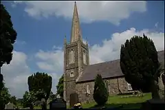 St Mellon's parish church, Loughbrickland | |
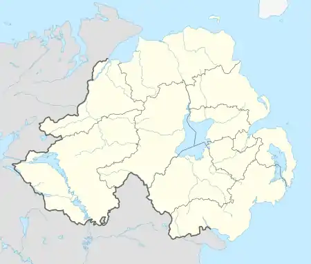 Loughbrickland Location within Northern Ireland | |
| Population | 693 |
| District | |
| Country | Northern Ireland |
| Sovereign state | United Kingdom |
| Post town | Banbridge |
| Postcode district | BT |
| Dialling code | 028 |
| Police | Northern Ireland |
| Fire | Northern Ireland |
| Ambulance | Northern Ireland |
| NI Assembly | |
History
Loughbrickland may have been the site where the Three Collas fought the Battle of Achadh Leithdheirg in 331 AD, defeating the forces of Fergus Foga, king of Ulster.[2][3] The victors killed Fergus and burned Emain Macha, the famous palace of the Ultonian kings, to the ground. The sovereignty of Ulster thus passed from the race of Ir to the race of Heremon. John O'Mahony the Gaelic scholar states that the battle site was commemorated by "a huge Carn of loose stones near Loughbrickland".[4] Samuel Lewis (publisher) in his "Topographical dictionary of Ireland - County Down" states - "At Drummillar is a vast cairn of loose stones, 60 feet high and 226 feet in circumference."[5] This Carn, known as Carn Cochy in the Annals of the Four Masters, stood seventy feet high but appears to have been destroyed when the Scarva to Banbridge railway line was constructed in 1859. What appears to be the Carn can be seen on the image of a 1778 map as a huge pile of stones to the left of the Loughbrickland to Scarva Road, about 2 miles outside Loughbrickland.
Four seventh-century saints are associated with the area: Nasad, Beoan, Ross and Mellan, hermits of Down. The three are recorded in the Martyrology of Aengus and are mentioned as having been interred "in one church: Tamlacht Menand on Loch Bricrend in Iveagh in Ulidia". The Annals of the Four Masters records two of these saints: "Beoan, Bishop and Mellan of Tamlacht Menan on Loch Bricrenn". These references suggest the existence of an early church in the townland of Meenan, around two miles from modern Loughbrickland.
Loughbrickland was a major seat of the Magennises of Iveagh. The Magennis castle was believed to be on the shores of Loughbrickland Lake, although they also inhabited the crannog on the lake as late as the seventeenth century. The Magennises were succeeded in the Loughbrickland area by Sir Marmaduke Whitechurch.[6] Probably the most prominent developer of the district, Whitechurch established villages, churches, and markets that formed the basis of the local infrastructure. Sir Marmaduke built his castle by the lake,[7] which was subsequently dismantled by Cromwell's army. The castle remained in ruins until 1812, when they were removed and a dwelling-house was erected on its site. Its exact location has never been accurately identified; possible sites range from the site of the Magennis castle to where the old Aghaderg School now stands to where the Church of Ireland built their rectory in 1801.
In 1690, William III camped near Loughbrickland with his army from 14 to 25 June, on his march to the Boyne. Tradition has it that William stayed overnight at Bovennet house, and mounted his horse from a stone on the corner of the Poyntzpass Road.
Demography
Loughbrickland is classified as a small village or hamlet by the Northern Ireland Statistics and Research Agency. On Census day (27 March 2011) there were 693 people living in Loughbrickland. Of these:
- 99.86% were from the white (including Irish Traveller) ethnic group;
- 49.49% belong to or were brought up Catholic and 45.31% belong to or were brought up'Protestant and Other Christian (including Christian related); and
- 51.52% indicated that they had a British national identity, 25.40% had an Irish national identity and 29.29% had a Northern Irish national identity.
- 10.57% had some knowledge of Irish;
- 4.98% had some knowledge of Ulster-Scots; and
- 2.11% did not have English as their first language.
Education
- Loughbrickland Primary School (closed September 2006)
- New-Bridge Integrated College
- St. Francis' Primary School
Places of interest
_-_geograph.org.uk_-_272004.jpg.webp)
The Loughbrickland ringfort, in the townland of Coolnacran, is a high status bivallate fort around 30.5 metres (100 ft) across. It dates to early Christian times. Besides Loughbrickland Crannóg, there is also reputed to have been a second crannog in the area, in a lake which is now Meenan bog, in the townland of Lisnagonnell.
Lewis's description of Aghaderg Parish from the Topographical Dictionary of Ireland states, "about half a mile to the south-west of Loughbrickland are three upright stones, called The Three Sisters of Greenan, apparently the remains of an ancient cromlech: they are situated on a gentle eminence, and near them is a fourth lying in a ditch."[8] While the fourth stone seems to have been forgotten in recent times, The Three Sisters came to be associated with a short alignment of three standing stones in the townland of Greenan, whose name comes from grianan, "the place of the sun", hinting that the stones may have been the site of midsummer and midwinter rituals. Only two of the original stones remains standing.[9]
The remains of Water Hill Fort (Dun Uisce) stand on a hill to the south of the lake.
Local tradition refers to an early monastic foundation, a Franciscan house, which is believed to have prospered in the townland of Drumsallagh from the early fifteenth century until 1569, when it suffered suppression under Elizabeth I. It lies in the valley to the west of the village. A manuscript attributed to Rev. John Deth, first Protestant Vicar of Aghaderg, claims that the monastery was quarried to provide building materials for the original Church of Ireland church in Loughbrickland, constructed in 1600. The manuscript also records that, according to information he received from one of the friars, the remains of the three aforementioned saints of Meenan had been previously reinterred in the chapel of the Franciscan monastery.
Notable people
- Patrick Brontë (né Brunty), father of the Brontë sisters and their brother Branwell, was born in a cottage four miles from Loughbrickland.
- Dermott Lennon, the 2002 Show Jumping World Champion, is a native of the village.[10]
- Enoch Powell, a Conservative Member of Parliament for Wolverhampton South West, lived at 14 Main Street.
- Helen Mabel Trevor, landscape and genre painter, was born in Loughbrickland.
References
- Placenames Database of Ireland
- http://www.lisburn.com/books/dromore-diocese/parish-aghaderg.html
- http://www.placenamesni.org/resultdetails.php?entry=17280
- JOHN O'MAHONY (1866). FORAS FEASA AR EIRINN DO REIR AN ATHAR, SEATHRUN CEITING, OLLAMH RE DIADHACHTA.THE HISTORY OF IRELAND, FROM THE GAELIEST PERIOD TO THE ENGLISH INBASION. pp. 726–.
- http://www.lecalehistory.co.uk/lewisA.htm
- Raymond. "Loughbrickland". Raymonds County Down Website. Retrieved 1 March 2013.
- Lewis, Samuel (1847). "Loughbrickland". A Topographical Dictionary of Ireland. 2 (2nd ed.). London. p. 275. Retrieved 16 February 2012.
- Lewis, Samuel (1837). "Aghaderg". A Topographical Dictionary of Ireland. 1 (1st ed.). London. pp. 14–15. Retrieved 16 February 2012.
- "Greenan Stone Row or Alignment, Co. Down (The Three Sisters)". megalithomania.com. Retrieved 16 February 2012.
- "Dermot Lennon: Champion of the World". Equestrian Federation of Ireland. Retrieved 1 March 2013.
| Authority control |
|---|