Magnolia, New Jersey
Magnolia is a borough in Camden County, New Jersey, United States. As of the 2010 United States Census, the borough's population was 4,341,[9][10][11] reflecting a decline of 68 (-1.5%) from the 4,409 counted in the 2000 Census, which had in turn declined by 452 (-9.3%) from the 4,861 counted in the 1990 Census.[20]
Magnolia, New Jersey | |
|---|---|
| Borough of Magnolia | |
| Motto(s): | |
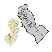 Magnolia highlighted in Camden County. Inset: Location of Camden County in New Jersey | |
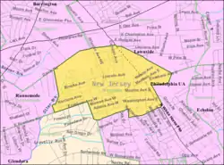 Census Bureau map of Magnolia, New Jersey | |
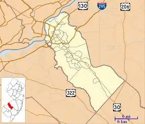 Magnolia Location in Camden County  Magnolia Location in New Jersey  Magnolia Location in the United States | |
| Coordinates: 39.856195°N 75.036397°W[3][4] | |
| Country | |
| State | |
| County | Camden |
| Incorporated | May 12, 1915 |
| Government | |
| • Type | Borough |
| • Body | Borough Council |
| • Mayor | BettyAnn Cowling-Carson (D, term ends December 31, 2023)[6] |
| • Municipal clerk | Christine M. Pippet[7] |
| Area | |
| • Total | 0.98 sq mi (2.53 km2) |
| • Land | 0.98 sq mi (2.53 km2) |
| • Water | 0.00 sq mi (0.00 km2) 0.00% |
| Area rank | 503rd of 565 in state 27th of 37 in county[3] |
| Elevation | 79 ft (24 m) |
| Population | |
| • Total | 4,341 |
| • Estimate (2019)[12] | 4,273 |
| • Rank | 397th of 566 in state 25th of 37 in county[13] |
| • Density | 4,485.3/sq mi (1,731.8/km2) |
| • Density rank | 131st of 566 in state 14th of 37 in county[13] |
| Time zone | UTC−05:00 (Eastern (EST)) |
| • Summer (DST) | UTC−04:00 (Eastern (EDT)) |
| ZIP Code | |
| Area code(s) | 609 and 856[16] |
| FIPS code | 3400742630[3][17][18] |
| GNIS feature ID | 0885288[3][19] |
| Website | www |
History
Magnolia was incorporated as a borough by an act of the New Jersey Legislature on April 14, 1915, from portions of the now-defunct Centre Township, and parts of Clementon, based on the results of a referendum held on May 12, 1915.[21] The borough was named for magnolia trees that grow in the area.[22][23]
Magnolia has been the site of one of seven remaining single-arch McDonald's signs in the United States, with the bulk of signs in the nation matching the company's trademarked Golden Arches.[24]
Geography
According to the United States Census Bureau, the borough had a total area of 0.98 square miles (2.53 km2), all of which was land.[3][4]
The borough borders the Camden County municipalities of Barrington, Gloucester Township, Lawnside, Runnemede and Somerdale.[25][26][27]
Demographics
| Historical population | |||
|---|---|---|---|
| Census | Pop. | %± | |
| 1920 | 1,245 | — | |
| 1930 | 1,522 | 22.2% | |
| 1940 | 1,552 | 2.0% | |
| 1950 | 1,883 | 21.3% | |
| 1960 | 4,199 | 123.0% | |
| 1970 | 5,893 | 40.3% | |
| 1980 | 4,881 | −17.2% | |
| 1990 | 4,861 | −0.4% | |
| 2000 | 4,409 | −9.3% | |
| 2010 | 4,341 | −1.5% | |
| 2019 (est.) | 4,273 | [12][28] | −1.6% |
| Population sources:1920-2000[29] 1920[30] 1920-1930[31] 1930-1990[32] 2000[33][34] 2010[9][10][11] | |||
Census 2010
The 2010 United States Census counted 4,341 people, 1,710 households, and 1,147 families in the borough. The population density was 4,485.3 per square mile (1,731.8/km2). There were 1,850 housing units at an average density of 1,911.5 per square mile (738.0/km2). The racial makeup was 74.71% (3,243) White, 18.27% (793) Black or African American, 0.30% (13) Native American, 1.89% (82) Asian, 0.05% (2) Pacific Islander, 2.21% (96) from other races, and 2.58% (112) from two or more races. Hispanic or Latino of any race were 7.83% (340) of the population.[9]
Of the 1,710 households, 28.1% had children under the age of 18; 45.4% were married couples living together; 15.5% had a female householder with no husband present and 32.9% were non-families. Of all households, 26.1% were made up of individuals and 8.7% had someone living alone who was 65 years of age or older. The average household size was 2.53 and the average family size was 3.08.[9]
21.8% of the population were under the age of 18, 8.9% from 18 to 24, 29.0% from 25 to 44, 28.1% from 45 to 64, and 12.2% who were 65 years of age or older. The median age was 38.3 years. For every 100 females, the population had 93.6 males. For every 100 females ages 18 and older there were 90.8 males.[9]
The Census Bureau's 2006-2010 American Community Survey showed that (in 2010 inflation-adjusted dollars) median household income was $53,125 (with a margin of error of +/- $7,496) and the median family income was $74,042 (+/- $10,349). Males had a median income of $49,196 (+/- $2,966) versus $38,523 (+/- $5,667) for females. The per capita income for the borough was $27,896 (+/- $1,765). About 1.0% of families and 4.7% of the population were below the poverty line, including 3.8% of those under age 18 and none of those age 65 or over.[35]
Census 2000
As of the 2000 United States Census[17] there were 4,409 people, 1,710 households, and 1,162 families residing in the borough. The population density was 4,543.3 people per square mile (1,755.0/km2). There were 1,836 housing units at an average density of 1,891.9 per square mile (730.8/km2). The racial makeup of the borough was 77.00% White, 17.80% African American, 0.23% Native American, 0.93% Asian, 0.02% Pacific Islander, 1.54% from other races, and 2.47% from two or more races. Hispanic or Latino of any race were 4.06% of the population.[33][34]
There were 1,710 households, out of which 30.6% had children under the age of 18 living with them, 48.4% were married couples living together, 15.1% had a female householder with no husband present, and 32.0% were non-families. 25.7% of all households were made up of individuals, and 8.4% had someone living alone who was 65 years of age or older. The average household size was 2.57 and the average family size was 3.12.[33][34]
In the borough the population was spread out, with 24.7% under the age of 18, 7.9% from 18 to 24, 33.2% from 25 to 44, 21.4% from 45 to 64, and 12.8% who were 65 years of age or older. The median age was 36 years. For every 100 females, there were 93.8 males. For every 100 females age 18 and over, there were 87.8 males.[33][34]
The median income for a household in the borough was $43,728, and the median income for a family was $50,791. Males had a median income of $38,480 versus $27,172 for females. The per capita income for the borough was $19,032. About 5.9% of families and 7.9% of the population were below the poverty line, including 10.9% of those under age 18 and 5.0% of those age 65 or over.[33][34]
Government
Local government
Magnolia is governed under the Borough form of New Jersey municipal government, one of 218 municipalities (of the 565) statewide that use this form, the state's most common form of government.[36] The governing body is comprised of a Mayor and a Borough Council, with all positions elected at-large on a partisan basis as part of the November general election. A Mayor is elected directly by the voters to a four-year term of office. The Borough Council is comprised of six members elected to serve three-year terms on a staggered basis, with two seats coming up for election each year in a three-year cycle.[5] The Borough form of government used by Magnolia is a "weak mayor / strong council" government in which council members act as the legislative body with the mayor presiding at meetings and voting only in the event of a tie. The mayor can veto ordinances subject to an override by a two-thirds majority vote of the council. The mayor makes committee and liaison assignments for council members, and most appointments are made by the mayor with the advice and consent of the council.[37][38]
As of 2020, the Mayor of the Borough of Magnolia is Democrat BettyAnn Cowling-Carson, whose term of office ends December 31, 2023.[39] Members of the Magnolia Borough Council are Council President Richard V. Krause Jr. (D, 2021), Paula Bonamassa (D, 2022), Anthony DePrince III (D, 2022), Mary F. Martz (D, 2020), Odell Saxton (D, 2021) and Steve Whalen (D, 2020).[40][41][42][43][44]
Federal, state and county representation
Magnolia is located in the 1st Congressional District[45] and is part of New Jersey's 5th state legislative district.[10][46][47]
For the 116th United States Congress, New Jersey's First Congressional District is represented by Donald Norcross (D, Camden).[48][49] New Jersey is represented in the United States Senate by Democrats Cory Booker (Newark, term ends 2021)[50] and Bob Menendez (Paramus, term ends 2025).[51][52]
For the 2018–2019 session (Senate, General Assembly), the 5th Legislative District of the New Jersey Legislature is represented in the State Senate by Nilsa Cruz-Perez (D, Barrington) and in the General Assembly by Patricia Egan Jones (D, Barrington) and William Spearman (D, Camden).[53][54] Spearman took office in June 2018 following the resignation of Arthur Barclay.[55]
Camden County is governed by a Board of Chosen Freeholders, whose seven members chosen at-large in partisan elections to three-year terms office on a staggered basis, with either two or three seats coming up for election each year.[56] As of 2018, Camden County's Freeholders are Freeholder Director Louis Cappelli Jr. (D, Collingswood, term as freeholder ends December 31, 2020; term as director ends 2018),[57] Freeholder Deputy Director Edward T. McDonnell (D, Pennsauken Township, term as freeholder ends 2019; term as deputy director ends 2018),[58] Susan Shin Angulo (D, Cherry Hill, 2018),[59] William F. Moen Jr. (D, Camden, 2018),[60] Jeffrey L. Nash (D, Cherry Hill, 2018),[61] Carmen Rodriguez (D, Merchantville, 2019)[62] and Jonathan L. Young Sr. (D, Berlin Township, 2020).[63][56]
Camden County's constitutional officers, all elected directly by voters, are County clerk Joseph Ripa (Voorhees Township, 2019),[64][65] Sheriff Gilbert "Whip" Wilson (Camden, 2018)[66][67] and Surrogate Michelle Gentek-Mayer (Gloucester Township, 2020).[68][69][70] The Camden County Prosecutor is Jill S. Mayer.[71]
Politics
As of March 23, 2011, there were a total of 2,918 registered voters in Magnolia, of which 1,170 (40.1%) were registered as Democrats, 367 (12.6%) were registered as Republicans and 1,381 (47.3%) were registered as Unaffiliated. There were no voters registered to other parties.[72]
In the 2012 presidential election, Democrat Barack Obama received 69.8% of the vote (1,383 cast), ahead of Republican Mitt Romney with 29.3% (580 votes), and other candidates with 0.9% (18 votes), among the 2,002 ballots cast by the borough's 3,162 registered voters (21 ballots were spoiled), for a turnout of 63.3%.[73][74] In the 2008 presidential election, Democrat Barack Obama received 66.2% of the vote (1,442 cast), ahead of Republican John McCain, who received around 30.1% (656 votes), with 2,177 ballots cast among the borough's 2,877 registered voters, for a turnout of 75.7%.[75] In the 2004 presidential election, Democrat John Kerry received 60.7% of the vote (1,293 ballots cast), outpolling Republican George W. Bush, who received around 37.3% (795 votes), with 2,129 ballots cast among the borough's 2,887 registered voters, for a turnout percentage of 73.7.[76]
In the 2013 gubernatorial election, Republican Chris Christie received 53.3% of the vote (555 cast), ahead of Democrat Barbara Buono with 44.9% (468 votes), and other candidates with 1.8% (19 votes), among the 1,070 ballots cast by the borough's 3,196 registered voters (28 ballots were spoiled), for a turnout of 33.5%.[77][78] In the 2009 gubernatorial election, Democrat Jon Corzine received 53.7% of the vote (640 ballots cast), ahead of both Republican Chris Christie with 37.2% (443 votes) and Independent Chris Daggett with 5.3% (63 votes), with 1,191 ballots cast among the borough's 2,942 registered voters, yielding a 40.5% turnout.[79]
Education
The Magnolia School District serves public school students in pre-kindergarten through eighth grade at Magnolia School.As of the 2018–19 school year, the district, comprised of one school, had an enrollment of 408 students and 39.1 classroom teachers (on an FTE basis), for a student–teacher ratio of 10.4:1.[80]
For ninth through twelfth grades, public school students attend Sterling High School, a regional high school serving students from Magnolia, Somerdale, Stratford, along with students from Hi-Nella and Laurel Springs who attend as part of sending/receiving relationships.[81][82] The high school is located in Somerdale. As of the 2018–19 school year, the high school had an enrollment of 958 students and 69.8 classroom teachers (on an FTE basis), for a student–teacher ratio of 13.7:1.[83]
Transportation
_at_Hurlock_Avenue_in_Magnolia%252C_Camden_County%252C_New_Jersey.jpg.webp)
Roads and highways
As of May 2010, the borough had a total of 17.53 miles (28.21 km) of roadways, of which 13.44 miles (21.63 km) were maintained by the municipality, 3.15 miles (5.07 km) by Camden County and 0.94 miles (1.51 km) by the New Jersey Department of Transportation.[84]
U.S. Route 30 is the main highway serving Magnolia. County Route 544 also traverses the borough.
Public transportation
NJ Transit offers bus service between Turnersville and Camden on the 403 route.[85][86]
Notable people
People who were born in, residents of, or otherwise closely associated with Magnolia include:
- Kristin Hunter (1931-2008), author best known for her first novel, God Bless the Child, published in 1964.[87]
References
- McCoy, Shawna. "Magnolia Celebrates The Fourth - And Its 80th - All Week Long The Square-mile Borough Turned A Park Into A Hub Of Fun. It's On Land Donated By A Town Founder's Family.", The Philadelphia Inquirer, July 9, 1995. Accessed August 6, 2011. "'Magnolia, as it enters into the next decade is looking ahead. We are anxiously looking forward to new business on the White Horse Pike,' said Cowling-Carson. 'But at the same time, continue to be 'One Square Mile of Friendliness.'"
- Kuperinsky, Amy. "'The Jewel of the Meadowlands'?: N.J.'s best, worst and weirdest town slogans", NJ Advance Media for NJ.com, January 22, 2015. Accessed July 12, 2016. "Magnolia, in Camden County (settled 1685), promises precisely 'One square mile ... of friendliness.' Helen Bradley, the town historian since 1975, knows how this one came to be. 'It was a school project for the sixth and seventh graders in 1966,' she immediately recalls."
- 2019 Census Gazetteer Files: New Jersey Places, United States Census Bureau. Accessed July 1, 2020.
- US Gazetteer files: 2010, 2000, and 1990, United States Census Bureau. Accessed September 4, 2014.
- 2012 New Jersey Legislative District Data Book, Rutgers University Edward J. Bloustein School of Planning and Public Policy, March 2013, p. 28.
- 2020 New Jersey Mayors Directory, New Jersey Department of Community Affairs. Accessed February 1, 2020.
- Office of the Municipal Clerk, Borough of Magnolia. Accessed February 26, 2020.
- U.S. Geological Survey Geographic Names Information System: Borough of Magnolia, Geographic Names Information System. Accessed March 7, 2013.
- DP-1 - Profile of General Population and Housing Characteristics: 2010 for Magnolia borough, Camden County, New Jersey Archived 2020-02-12 at Archive.today, United States Census Bureau. Accessed October 10, 2012.
- Municipalities Sorted by 2011-2020 Legislative District, New Jersey Department of State. Accessed February 1, 2020.
- Profile of General Demographic Characteristics: 2010 for Magnolia borough Archived 2013-08-12 at the Wayback Machine, New Jersey Department of Labor and Workforce Development. Accessed October 10, 2012.
- Annual Estimates of the Resident Population for Minor Civil Divisions in New Jersey: April 1, 2010 to July 1, 2019, United States Census Bureau. Accessed May 21, 2020.
- GCT-PH1 Population, Housing Units, Area, and Density: 2010 - State -- County Subdivision from the 2010 Census Summary File 1 for New Jersey Archived 2015-05-26 at Archive.today, United States Census Bureau. Accessed October 10, 2012.
- Look Up a ZIP Code for Magnolia, NJ, United States Postal Service. Accessed October 10, 2012.
- Zip Codes, State of New Jersey. Accessed August 28, 2013.
- Area Code Lookup - NPA NXX for Magnolia, NJ, Area-Codes.com. Accessed August 28, 2013.
- U.S. Census website , United States Census Bureau. Accessed September 4, 2014.
- Geographic codes for New Jersey, Missouri Census Data Center. Accessed September 1, 2019.
- US Board on Geographic Names, United States Geological Survey. Accessed September 4, 2014.
- Table 7. Population for the Counties and Municipalities in New Jersey: 1990, 2000 and 2010, New Jersey Department of Labor and Workforce Development, February 2011. Accessed October 10, 2012.
- Snyder, John P. The Story of New Jersey's Civil Boundaries: 1606-1968, Bureau of Geology and Topography; Trenton, New Jersey; 1969. p. 107. Accessed October 10, 2012.
- Hutchinson, Viola L. The Origin of New Jersey Place Names, New Jersey Public Library Commission, May 1945. Accessed September 4, 2015.
- Comegno, Carol. "Magnolia celebrates 100th anniversary; Magnolia is small-town America where people know and care about one another and all know its motto: "One Square Mile of Friendliness.'", Courier-Post, May 15, 2015. "Magnolia is small-town America where people know and care about one another and all know its motto: 'One Square Mile of Friendliness.'"
- Strunsky, Steve. "Only 7 original McDonald's golden arches still exist, and one is in N.J.", NJ Advance Media for NJ.com, December 10, 2018, updated September 24, 2019. Accessed August 18, 2020. "The single-arch marquee is an original version that dates to 1962, and is one of only a half dozen like it from among the 37,000 McDonald's locations around the world, according to collectors, curators and other sign experts who have been wowed by what may be the Borough of Magnolia's most widely-renowned piece of architecture.... Seltzer said the Magnolia sign is one of just seven remaining single-arch McDonald's 'crest' signs scattered along the byways of America, still bearing the family crest of Richard and Maurice McDonald."
- Areas touching Magnolia, MapIt. Accessed February 26, 2020.
- Municipalities within Camden County, NJ, Delaware Valley Regional Planning Commission. Accessed February 26, 2020.
- New Jersey Municipal Boundaries, New Jersey Department of Transportation. Accessed November 15, 2019.
- Census Estimates for New Jersey April 1, 2010 to July 1, 2019, United States Census Bureau. Accessed May 21, 2020.
- Barnett, Bob. Population Data for Camden County Municipalities, 1850 - 2000, WestJersey.org, January 6, 2011. Accessed October 10, 2012.
- Compendium of censuses 1726-1905: together with the tabulated returns of 1905, New Jersey Department of State, 1906. Accessed October 21, 2013.
- Fifteenth Census of the United States: 1930 - Population Volume I, United States Census Bureau, p. 715. Accessed October 10, 2012.
- Table 6. New Jersey Resident Population by Municipality: 1930 - 1990, New Jersey Department of Labor and Workforce Development. Accessed June 28, 2015.
- Census 2000 Profiles of Demographic / Social / Economic / Housing Characteristics for Magnolia borough, New Jersey Archived 2013-08-12 at the Wayback Machine, United States Census Bureau. Accessed October 10, 2012.
- DP-1: Profile of General Demographic Characteristics: 2000 - Census 2000 Summary File 1 (SF 1) 100-Percent Data for Magnolia borough, Camden County, New Jersey Archived 2020-02-12 at Archive.today, United States Census Bureau. Accessed October 10, 2012.
- DP03: Selected Economic Characteristics from the 2006-2010 American Community Survey 5-Year Estimates for Magnolia borough, Camden County, New Jersey Archived 2020-02-12 at Archive.today, United States Census Bureau. Accessed June 21, 2012.
- Inventory of Municipal Forms of Government in New Jersey, Rutgers University Center for Government Studies, July 1, 2011. Accessed November 18, 2019.
- Cerra, Michael F. "Forms of Government: Everything You've Always Wanted to Know, But Were Afraid to Ask" Archived 2014-09-24 at the Wayback Machine, New Jersey State League of Municipalities. Accessed November 30, 2014.
- "Forms of Municipal Government in New Jersey", p. 6. Rutgers University Center for Government Studies. Accessed June 3, 2015.
- Honorable Mayor BettyAnn Cowling-Carson, Borough of Magnolia. Accessed May 7, 2020.
- Borough Council, Borough of Magnolia. Accessed May 7, 2020.
- 2019 User Friendly Budget, Borough of Magnolia. Accessed May 7, 2020.
- Official Election Results 2019 General Election November 5, 2019, Camden County, New Jersey, updated November 15, 2019. Accessed January 1, 2020.
- Official Election Results 2018 General Election November 6, 2018, Camden County, New Jersey, amended December 4, 2018. Accessed January 1, 2019.
- Official Election Results 2017 General Election November 7, 2017, Camden County, New Jersey, November 16, 2017. Accessed January 1, 2018.
- Plan Components Report, New Jersey Redistricting Commission, December 23, 2011. Accessed February 1, 2020.
- 2019 New Jersey Citizen's Guide to Government, New Jersey League of Women Voters. Accessed October 30, 2019.
- Districts by Number for 2011-2020, New Jersey Legislature. Accessed January 6, 2013.
- Directory of Representatives: New Jersey, United States House of Representatives. Accessed January 3, 2019.
- Full Biography, Congressman Donald Norcross. Accessed January 3, 2019. "Donald and his wife Andrea live in Camden City and are the proud parents of three grown children and grandparents of two."
- About Cory Booker, United States Senate. Accessed January 26, 2015. "He now owns a home and lives in Newark's Central Ward community."
- Biography of Bob Menendez, United States Senate, January 26, 2015. "He currently lives in Paramus and has two children, Alicia and Robert."
- Senators of the 116th Congress from New Jersey. United States Senate. Accessed April 17, 2019. "Booker, Cory A. - (D - NJ) Class II; Menendez, Robert - (D - NJ) Class I"
- Legislative Roster 2018-2019 Session, New Jersey Legislature. Accessed July 3, 2018.
- District 5 Legislators, New Jersey Legislature. Accessed July 3, 2018.
- Johnson, Brent. "Yet another new lawmaker takes office in N.J.", NJ Advance Media for NJ.com, July 2, 2018. Accessed July 3, 2018. "Former Camden councilman William Spearman was sworn in Saturday as the newest member of the state Assembly, replacing Arthur Barclay, who resigned last month amid assault charges stemming from a domestic violence incident."
- About the Freeholder Board, Camden County, New Jersey. Accessed June 6, 2018.
- Louis Cappelli Jr. , Camden County, New Jersey. Accessed June 6, 2018.
- Edward T. McDonnell, Camden County, New Jersey. Accessed June 6, 2018.
- Susan Shin Angulo, Camden County, New Jersey. Accessed June 6, 2018.
- William F. Moen Jr.l, Camden County, New Jersey. Accessed June 6, 2018.
- Jeffrey L. Nash, Camden County, New Jersey. Accessed June 6, 2018.
- Carmen Rodriguez, Camden County, New Jersey. Accessed June 6, 2018.
- Jonathan L. Young Sr., Camden County, New Jersey. Accessed June 6, 2018.
- County Clerk Joseph Ripa, Camden County, New Jersey. Accessed June 6, 2018.
- Members List: Clerks, Constitutional Officers Association of New Jersey. Accessed June 6, 2018.
- Sheriff Gilbert "Whip" Wilson, Camden County, New Jersey. Accessed June 6, 2018.
- Members List: Sheriffs, Constitutional Officers Association of New Jersey. Accessed June 6, 2018.
- Surrogate Michelle Gentek-Mayer, Camden County, New Jersey. Accessed June 6, 2018.
- Members List: Surrogates , Constitutional Officers Association of New Jersey. Accessed June 6, 2018.
- Your Government, Camden County, New Jersey. Accessed June 6, 2018.
- "Prosecutor Jill S. Mayer". Camden County. Retrieved January 23, 2021.
- Voter Registration Summary - Camden, New Jersey Department of State Division of Elections, March 23, 2011. Accessed October 15, 2012.
- "Presidential General Election Results - November 6, 2012 - Camden County" (PDF). New Jersey Department of Elections. March 15, 2013. Retrieved December 24, 2014.
- "Number of Registered Voters and Ballots Cast - November 6, 2012 - General Election Results - Camden County" (PDF). New Jersey Department of Elections. March 15, 2013. Retrieved December 24, 2014.
- 2008 Presidential General Election Results: Camden County, New Jersey Department of State Division of Elections, December 23, 2008. Accessed October 15, 2012.
- 2004 Presidential Election: Camden County, New Jersey Department of State Division of Elections, December 13, 2004. Accessed October 15, 2012.
- "Governor - Camden County" (PDF). New Jersey Department of Elections. January 29, 2014. Retrieved December 24, 2014.
- "Number of Registered Voters and Ballots Cast - November 5, 2013 - General Election Results - Camden County" (PDF). New Jersey Department of Elections. January 29, 2014. Retrieved December 24, 2014.
- 2009 Governor: Camden County Archived 2012-10-17 at the Wayback Machine, New Jersey Department of State Division of Elections, December 31, 2009. Accessed October 15, 2012.
- District information for Magnolia School District, National Center for Education Statistics. Accessed April 1, 2020.
- Comprehensive Annual Financial Report For the Fiscal Year Ended June 30, 2011, Sterling High School District. Accessed December 8, 2014. "The purpose of the School District is to provide educational services for resident students in grades 9 through 12 that reside in the Borough's of Magnolia, Somerdale and Stratford. In addition, the School District provides educational services for students in grades 9 through 12 received, on a tuition basis, from the Laurel Springs School District and the Hi-Nella School District."
- "Sterling High School District; Somerdale, New Jersey - Comprehensive Annual Financial Report for the Fiscal Year Ended June 30, 2011", Sterling High School District. Accessed October 21, 2013. "The purpose of the School District is to provide educational services for resident students in grades 9 through 12 that reside in the Borough's of Magnolia, Somerdale and Stratford. In addition, the School District provides educational services for students in grades 9 through 12 received, on a tuition basis, from the Laurel Springs School District and the Hi-Nella School District."
- School data for Sterling High School, National Center for Education Statistics. Accessed April 1, 2020.
- Camden County Mileage by Municipality and Jurisdiction, New Jersey Department of Transportation, May 2010. Accessed July 18, 2014.
- Camden County Bus/Rail Connections, NJ Transit, backed up by the Internet Archive as of May 22, 2009. Accessed August 6, 2011.
- South Jersey Transit Guide Archived 2018-09-29 at the Wayback Machine, Cross County Connection, as of April 1, 2010. Accessed September 29, 2014.
- Morrison, John F. "Kristin Hunter Lattany, novelist and activist, dies at 77" Archived 2016-02-22 at the Wayback Machine, Philadelphia Daily News, November 21, 2008, copied at AlYoung.org. Accessed September 28, 2017. "She died Friday of a heart attack after collapsing in her home in Magnolia, N.J. She was 77.... She was living in Magnolia when she first was exposed to the charms of South Street, from which, she said, much of her fiction sprang."
External links
| Wikimedia Commons has media related to Magnolia, New Jersey. |
Municipalities and communities of Camden County, New Jersey, United States | ||
|---|---|---|
| Cities | 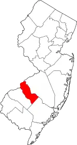 Map of New Jersey highlighting Camden County | |
| Boroughs | ||
| Townships | ||
| CDPs | ||
| Other unincorporated communities | ||
| ||
| Authority control |
|---|