Mahabubabad district
Mahabubabad district is a district in the Indian state of Telangana.[2][3] It was a part of the Warangal district prior to the re-organisation of districts in the state in October 2016.The district shares boundaries with Suryapet, Khammam, Bhadradri Kothagudem, Warangal Rural, Jayashankar Bhupalpalle and Jangaon districts. It consists of Dornakal, Mahabubabad, Maripeda, Thorrur Municipalities.
Mahabubabad district | |
|---|---|
District of Telangana | |
 Pandavula Gutta | |
.svg.png.webp) Location of Mahabubabad district in Telangana | |
| Country | India |
| State | Telangana |
| Headquarters | Mahabubabad |
| Tehsils | 16 |
| Government | |
| • District collector | Sri V.P.Goutham |
| • Lok Sabha constituencies | Mahabubabad |
| • Vidhan Sabha constituencies | Mahabubabad, Dornakal |
| Area | |
| • Total | 2,876.70 km2 (1,110.70 sq mi) |
| Population (2011) | |
| • Total | 774,549 |
| • Density | 270/km2 (700/sq mi) |
| Time zone | UTC+05:30 (IST) |
| Vehicle registration | TS–26[1] |
| Website | mahabubabad |
Geography
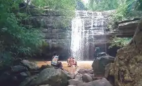
The district is spread over an area of 2,876.70 square kilometres (1,110.70 sq mi).[4] The region is mostly plain with occasional hillocks. Most of the land is used for agriculture.The mandals Bayyaram and Garla have rich iron ore and coal deposits.It also has Bheemunipadam waterfall and Edubavula waterfall. There are several popular hillocks such as Pandavula Guttalu in Bayyaram Mandal (Pandavula Guhalu, Thirumalagiri is different one, located in Jayshankar Bhupalpally district, east of Warangal).
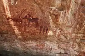
The district is also famous for Kuravi Veerabhadra Swamy temple
Demographics
As of 2011 Census of India, the district has a population of 774,549.[4] Percentage of males is 50.10% and 49.9% females. Most of the population lives in villages with 90.14% rural population and 9.86% urban population. Literacy percentage of the district is 57.1% below the state average of 66.5%. The district has significant amount of scheduled tribes population, called Lambadas with about 37.8% whereas scheduled castes are about 13.5%.
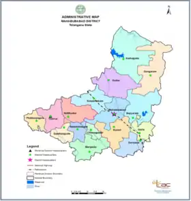
Administrative divisions
The district has two revenue divisions, Mahabubabad and Thorrur and is sub-divided into 16 mandals.
Mandals
The district has sixteen mandals .
The following are the list of mandals.
- Mahabubabad
- Kuravi
- Kesamudram
- Dornakal
- Gudur
- Kothaguda
- Gangaram
- Bayyaram
- Garla
- Chinnagudur
- Danthalapalle
- Thorrur
- Nellikudur
- Maripeda
- Narsimhulapet
- Peddavangara
See also
- List of districts in Telangana
References
- "Telangana New Districts Names 2016 Pdf TS 31 Districts List". Timesalert.com. 11 October 2016. Retrieved 11 October 2016.
- "Mahabubabad district" (PDF). Chief Commissioner of Land Administration. Archived from the original (PDF) on 9 September 2016. Retrieved 22 August 2016.
- "New districts map". newdistrictsformation.telangana.gov.in. Retrieved 22 August 2016.
- "New districts". Andhra Jyothy.com. March 2017. Retrieved 8 March 2017.
External links
| Wikimedia Commons has media related to Mahabubabad district. |
Places adjacent to Mahabubabad district | ||||||||||
|---|---|---|---|---|---|---|---|---|---|---|
| ||||||||||
| portal | |
|---|---|
| Dynasties | |
| Districts |
|
| Commissionerates | |
| Major cities | |
| Tourism |
|
| Municipal corporations | |
| Related lists |
|