Karimnagar district
Karimnagar district is one of the 33 districts of the Indian state of Telangana. Karimnagar city is its administrative headquarters.[2] The district shares boundaries with Peddapalli, Jagityal, Sircilla, Siddipet, Jangaon, Warangal urban and Jayashankar Bhupalapally districts.
Karimnagar district | |
|---|---|
District of Telangana | |
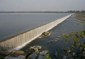
 Lower Manair Dam reservoir, Karimnagar | |
.svg.png.webp) Location of Karimnagar district in Telangana | |
| Coordinates (Karimnagar): 18.43694°N 79.124167°E | |
| Country | India |
| State | Telangana |
| Headquarters | Karimnagar |
| Government | |
| • District collector | Konduru Shashanka |
| Area | |
| • Total | 2,128 km2 (822 sq mi) |
| Population (2011) | |
| • Total | 1,005,711 |
| • Density | 470/km2 (1,200/sq mi) |
| • Urban | 30.72% |
| Demographics | |
| • Literacy | 69.16% |
| • Sex ratio | 993 |
| Time zone | UTC+05:30 (IST) |
| Vehicle registration | TS–02[1] |
| Website | karimnagar |
Etymology
Karimnagar was originally called Elagandala.[3] Later Kannada kingdoms such as Western Chalukyas ruled it. It was part of the great Satavahana Empire. Later, the ruling Nizams of Hyderabad changed the name to Karimnagar, derived from the name of Shahenshah E Karimnagar Syed Kareemullah Shah Quadrii nithinvasi.
History
After the districts re-organisation in October 2016, 3 new districts were carved out from the erstwhile Karimnagar district to form three new districts of Jagtial district, Peddapalli district and Rajanna Sircilla district.[4] Few mandals were merged into other newly formed districts of Warangal Urban, Siddipet, Jayashankar Bhupalpally.
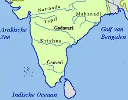
Geography
The district is spread over an area of 2,128 square kilometres (822 sq mi). Karimnagar is the fifth smallest district in Telangana by area.[4] Karimnagar shares it boundaries with Jagtial to its north, Peddapalli district on north-east, Warangal Urban district towards South, Siddipet district on south-west, Rajanna Sircilla to the West and Jayashankar Bhupalapally on East.
Demographics
As of 2011 Census of India, the district has a population of 10,05,711.It has a literacy rate of 69.16% and density of 423 persons per km2., making it fifth most literate and densely populated district among 31 districts of Telangana. Total urban population of the district is 3,08,984, which is 30.72% of total population.[5] It has a single municipal corporation (Karimnagar) and four municipalities under the new municipalities act (Huzurabad, Jammikunta, Choppadandi and Kothapalli). The population of the Satavahana Urban Development Authority has a population of over 4,80,000 in Karimnagar and its urban agglomeration.
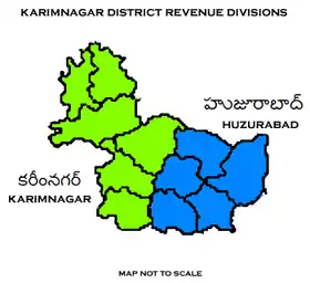
Administrative divisions
The district is divided into two revenue divisions of Karimnagar and Huzurabad. These are sub-divided into sixteen mandals. There are 210 revenue villages and 276 Gram-Panchyats in the district.[4] K.Shashanka is the present collector of the district.[6]
Mandals
The below table categorizes 16 mandals into their respective revenue divisions in the district:[7]
| S.No. | Karimnagar revenue division | Huzurabad revenue division |
|---|---|---|
| 1 | Kothapalli | Veenavanka |
| 2 | Karimnagar | V.Saidapur |
| 3 | Karimnagar (rural) | Sankarapatnam |
| 4 | Manakondur | Huzurabad |
| 5 | Timmapur | Jammikunta |
| 6 | Ganneruvaram | Ellanthakunta |
| 7 | Gangadhara | |
| 8 | Ramadugu | |
| 9 | Choppadandi | |
| 10 | Chigurumamidi |
Economy
Granite industry of the district include, Tan Brown and Maple Red variety of granite. In Karimnagar district, there are over 600 stone quarries spread over several mandals such as Karimnagar, Manakondur, Mallial, Kesavapatnam etc.
In 2006, the Indian government named undivided Karminagar district as one of the country's 250 most impoverished districts (out of 640).[8] It is one of the nine earlier integrated districts in Telangana currently receiving funds from the Backward Regions Grant Fund Programme (BRGF).[8]
Notable people
- P. V. Narasimha Rao, Former Prime Minister of India[9]
- Vidyasagar Rao, Honourable Maharashtra Governor
- Dr. C. Narayana Reddy, writer, Jnanpith Award recipient.
- Justice N. Kumarayya, Retired Chief Justice of Andhra Pradesh & ex-judge, World Bank Administrative Tribunal
- Midde Ramulu (Oggu Katha artist from Hanmajipet village)
- Anabheri Prabhakar Rao, Freedom Fighter and Telangana Rebellion Martyr
- Mallojula Koteswara Rao
- G. Ram Reddy, architect of distance education and the father of open learning in India.
- Paidi Jairaj, film actor, director and producer. He was recipient of Dadasaheb Phalke Award for lifetime achievement in 1980.
- Siva Reddy, popular Telugu language comedian and actor.
See also
- List of districts in Telangana
- Gattubhoothkur
- Moqdumpur
References
- http://www.sakshipost.com/telangana/2016/10/13/vehicle-registration-codes-for-new-districts-in-telangana
- "District Census Handbook – Adilabad" (PDF). Census of India. p. 9. Retrieved 20 November 2015.
- "New districts". Andhra Jyothy.com. 8 October 2016. Retrieved 8 October 2016.
- http://epaper.sakshi.com/984919/Karimnagar-District/30-10-2016#page/10/2
- "K Chandrasekhar Rao appoints collectors for new districts". Deccan Chronicle. 11 October 2016. Retrieved 13 October 2016.
- "Clipping of Andhra Jyothy Telugu Daily – Hyderabad". Andhra Jyothy. Retrieved 8 October 2016.
- Ministry of Panchayati Raj (8 September 2009). "A Note on the Backward Regions Grant Fund Programme" (PDF). National Institute of Rural Development. Archived from the original (PDF) on 5 April 2012. Retrieved 27 September 2011.
- "Archived copy" (PDF). Archived from the original (PDF) on 19 January 2010. Retrieved 19 January 2010.CS1 maint: archived copy as title (link)
External links
| Wikivoyage has a travel guide for Karimnagar. |
| Wikimedia Commons has media related to Karimnagar district. |
Places adjacent to Karimnagar district | |
|---|---|
| portal | |
|---|---|
| Dynasties | |
| Districts |
|
| Commissionerates | |
| Major cities | |
| Tourism |
|
| Municipal corporations | |
| Related lists |
|