Warangal Urban district
Warangal Urban district is a district located in the northern region of the Indian state of Telangana. The district headquarters are located at Hanamkonda.[3]
Warangal Urban district | |
|---|---|
District of Telangana | |
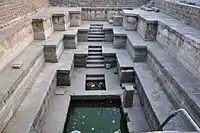
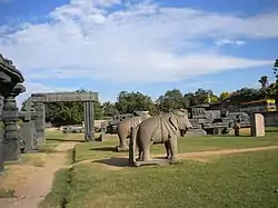 Statues in Warangal Fort | |
.svg.png.webp) Location of Warangal Urban district in Telangana | |
| Country | |
| State | Telangana |
| Headquarters | Warangal |
| Tehsils | 12 |
| Government | |
| • District collector | Rajeevgandhi. Hanumanthu |
| • Vidhan Sabha constituencies | Telangana Assembly |
| Area | |
| • Total | 1,304.50 km2 (503.67 sq mi) |
| Population (2011) | |
| • Total | 1,135,707 |
| • Density | 870/km2 (2,300/sq mi) |
| Time zone | UTC+05:30 (IST) |
| Vehicle registration | TS–03[1][2] |
| Website | warangalurban |
_Revenue_division.png.webp)
History
Warangal Rural district consists of many prehistoric habitation sites, which were explored by the Indian archaeological authorities. Paleolithic Rock art paintings are found at Pandavula gutta[4]
Padmakshi Gutta, a Jain temple dedicated to Padmavati located on a hilltop in the heart of the town of Hanamkonda, was originally constructed during the Kakatiya era. The temple has sculptures of Jain tirthankaras and other Jain gods and goddesses. The Kadalalaya basadi or Padmakshi Temple is built on a large rocky outcrop.
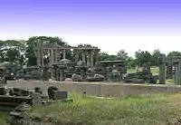
The Kakatiyas left many monuments, including impressive fortress, four massive stone gateways, the Swayambhu temple dedicated to Shiva, and the Ramappa temple situated near Ramappa Lake. Prominent rulers included Ganapathi Deva, Prathapa Rudra, and Rudrama Devi. After the defeat of Pratapa Rudra, the Musunuri Nayaks united 72 Nayak chieftains and captured Warangal from Delhi sultanate and ruled for fifty years. Jealousy and mutual rivalry between Nayaks ultimately led to the downfall of Hindus in 1370 and the rise of the Bahmani Sultanate.
The Bahmani Sultanate later broke up into several smaller sultanates, of which the Golconda sultanate ruled Warangal. The Mughal emperor Aurangzeb conquered Golconda in 1687, and it remained part of the Mughal empire until the southern provinces of the empire split away to become the state of Hyderabad in 1724 which included the Telangana region and some parts of Maharashtra and Karnataka. Hyderabad became an Indian state in 1948. In 1956 Hyderabad was partitioned as part of the States Reorganisation Act, and Telangana, the Telugu-speaking region of Hyderabad state which includes Warangal, became part of Andhra Pradesh. After the bifurcation of the state of Andhra Pradesh, the district became a part of the new state of Telangana.
Formation of District
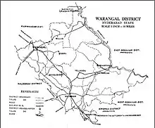
During rule of Nizam of Hyderabad, State of Hyderabad was divided in many small Circars. Warangal was made as one the Circars in the early 1800s.[5] In 1866 Circars was Abolished and merged to create districts, Warangal district was created by merging Warungal,[6] Khummettu[7] and part of Bhonagheer circars. Jangaon area from Bhongir Circar was transferred to warangal and kamalpur area of warangal transferred to Karimnagra district. In 1905 when Princely state of Hyderabad sub divided into Four Division namely 1.Aurangabad Division, 2.Gulbarga Division, 3.Gulshanabad Division, 4.Warangal Division. During formation divisions again districts were delimited in 1905 Jangaon(Cherial) Taluka and Kodar(Kodad) Sub Taluka transferred to Nalgonda District from Warangal district.[8] In 1905 AD, Warangal district was formed with Warangal, Pakala, Khammam, Yellandu, Mahabubabad, Madhira, Palvancha taluks and some area of old palvancha sanstan and some jagirs.This was bigger than many districts of Hyderabad state.[9]
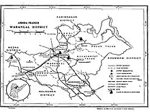
Warangal district was divided to facilitate administrative control and on October 1, 1953 the Khmman district was formed. Khammam, Yellandu, Madhira, Burugunpahad and Palavancha talukas have been made part of it. Warangal, Mulugu, Mahaboobabad, Pakala remained in Warangal district. But Parkaala from Karimnagar and Jangaon from Nalgonda have become part of Warangal district. District uses to consist of 6 talukas and 2 revenue divisions which later increased to 15 talukas in 1979. In 1985 when N. T. Rama Rao introduces mandal system in warangal district was divided in to 50 mandals, but again warangal mandal was curved out from Hanamkonda madal consisting only urban area of warangal which increased to total 51 mandals and revenue divisions increased to 5 in warangal district.[10]
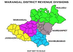
Present Warangal Urban district was curved out from old warangal district which split in to 5 new districts they are Warangal urban, warangal rural, Jangaon, Jayashanker and Mahabubabad in October 2016 along with other total new 21 districts. Three mandals from karaminagar district was merged in warangal urban district and 4 new mandals were created are Inavole, Kazipet, Khila Warangal and Velair total reaching to 11 mandals and one revenue division.
Geography
Warangal district occupies an area of 1,304.50 square kilometres (503.67 sq mi).[11]
Demographics
As of 2011 Census of India, the district has a population of 1,135,707.[11]
Administrative divisions
The district has only one revenue division i.e., Warangal and is sub-divided into 11 mandals.[11] Prashanth J. Patil is the present collector of the district.[12]
Mandals
| S.No. | Revenue Mandal [13] |
|---|---|
| 1 | Warangal |
| 2 | Khila Warangal |
| 3 | Hanamkonda |
| 4 | Kazipet |
| 5 | Inavolu |
| 6 | Hasanparthy |
| 7 | Velair |
| 8 | Dharmasagar |
| 9 | Elkathurthi |
| 10 | Bheemadevarapalli |
| 11 | Kamalapur |
Economy
In 2006 the Indian government named Warangal one of the country's 250 most backward districts (out of a total of 640).[14] It is one of the thirteen districts in Andhra Pradesh currently receiving funds from the Backward Regions Grant Fund Programme (BRGF).[14]
Culture
In February 2013, Warangal was accorded World Heritage city status by UNESCO.[15] A few tourist attractions include:
A few of the notable personalities from the district include, Rudrama Devi, Kaloji Narayana Rao, Kothapalli Jayashankar, Nerella Venumadhav, and P. V. Narasimha Rao.
Transport
National Highway 163 (India) between Hyderabad – Bhopalpatnam of Chhattisgarh, National Highway 563 (India) between Jagitial-Khammam passes through the district. Warangal has two railway stations Kazipet Railway Station and Warangal Railway Station, which connects South and North India. The district has a small airport in Mamnoor, which can accommodate small aircraft like the ATR 42. This airport is currently used by police for gliding sorties, skeet shooting and aero-modeling.[16]
Education
The schools in the district are under the administration of a District Education Officer controlled by Department of Education..[17] Some popular schools in warangal urban are DELHI PUBLIC SCHOOL (DPS) , GREENWOOD GROUP OF EDUCATIONAL INSTITUTIONS [CBSE] in erragattugutta at KAKATIYA INSTITUTION OF TECHNOLOGY AND SCIENCE (KITS) and at hunter road , ST. GABRIEL'S in Kazipet, TEJASWI GROUP, WARANGAL PUBLIC SCHOOL, EKASHILA, S R Educentre, Waddepally. Kashinath is the present Intermediate education officer, who oversees the junior colleges in the district for Telangana Board of Intermediate Education.[18]
Some of the major educational institutions include, National Institute of Technology, Kakatiya Medical College, Kakatiya University, Kaloji Narayana Rao University of Health Sciences, University Arts and Science College, Kakatiya Institute of Technology and Science.
See also
- List of districts in Telangana
References
- http://www.sakshipost.com/telangana/2016/10/13/vehicle-registration-codes-for-new-districts-in-telangana
- "Vehicle Registration Codes For New Districts In Telangana". Sakshipost. Retrieved 13 October 2016.
- "Warangal (Urban) district" (PDF). New Districts Formation Portal. Retrieved 11 October 2016.
- http://www.aparchaeologymuseum.com/wp-content/uploads/2012/05/Warangal-dt.pdf
- "1854 Pharoah and Company Map of the Hyderabad, Sangareddy and Nalgonda Districts of Telangana, India".
- "1854 Pharoah and Company Map of the Hyderabad state, Warangal and karimnagar Districts of Telangana, India".
- "1854 Pharoah and Company Map of the Hyderabad state, Warangal and khammam Districts of Telangana, India".
- Yazdani, Ghulam (1937). "Hyderabad State". Atlantic Publishers & Distri – via Google Books.
- "Know Your Corporation".
- "census2011".
- "New districts". Andhra Jyothy.com. 8 October 2016. Retrieved 8 October 2016.
- "K Chandrasekhar Rao appoints collectors for new districts". Deccan Chronicle. 11 October 2016. Retrieved 13 October 2016.
- https://warangalurban.telangana.gov.in/mandals-and-villages/
- Ministry of Panchayati Raj (8 September 2009). "A Note on the Backward Regions Grant Fund Programme" (PDF). National Institute of Rural Development. Retrieved 27 September 2011.
- "TV9 – Warangal accorded World Heritage town status by UNESCO – Telugu TVTelugu TV". Telugutv.au.com. 28 February 2013. Retrieved 8 March 2013.
- Mamnoor airport to function only after 2030
- "Warangal DEO". deowarangal.net. Retrieved 13 October 2016.
- "BIE announces IE officers for new districts". The Hans India. Retrieved 13 October 2016.
External links
| Wikimedia Commons has media related to Warangal district. |
Places adjacent to Warangal Urban district | ||||||||||
|---|---|---|---|---|---|---|---|---|---|---|
| ||||||||||
| portal | |
|---|---|
| Dynasties | |
| Districts |
|
| Commissionerates | |
| Major cities | |
| Tourism |
|
| Municipal corporations | |
| Related lists |
|
| States | ||
|---|---|---|
| Union territories | ||
| Related topics |
| |