Khammam district
Khammam district is a district in the eastern region of the Indian state of Telangana. The city of Khammam is the district headquarters. The district shares boundaries with Suryapet, Mahabubabad, Bhadradri districts and with Andhra pradesh state.
Khammam district | |
|---|---|
District of Telangana | |
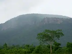 Ratham Hills near Pamulapalli | |
.svg.png.webp) Location of Khammam district in Telangana | |
| Country | India |
| State | Telangana |
| Headquarters | Khammam |
| Tehsils | 21 |
| Government | |
| • District collector | Sri R.V. Karnan, IAS |
| • Lok Sabha constituencies | 1 |
| • Vidhan Sabha constituencies | 10 |
| Area | |
| • Total | 4,360 km2 (1,680 sq mi) |
| Population (2011)[1] | |
| • Total | 1,401,639 |
| • Density | 320/km2 (830/sq mi) |
| Time zone | UTC+05:30 (IST) |
| Vehicle registration | TS–4[2] Sakshi |
| Website | khammam |
History
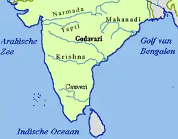
Paleolithic man probably roamed around the areas of lower Godavari valley[3] and the surroundings of Bhadrachalam, Kothagudem, Wyra, Sathupally and Paloncha Taluks in the district. Prehistoric rock paintings were found near Neeladri konda[4] near Lankapalli of Sathupally Taluk.
Megalithic Dolmens were found at Janampet[5] of Pinapaka Taluk. Megalithic site on the campus of Government Degree college in Khammam has yielded pottery and skeletal remains.[6] Kistapuram[7] and Padugonigudem[8] villages in Gundala Taluk of the district were rich in Megalithic cultural remnants explored and discovered recently.
The southern parts of Khammam district flourished as famous Buddhist centers along with Amaravathi and Vijayapuri along the rivulets Munneru, Wyra and Murredu. Important Buddhist sites in the district are Nelakondapalli, Mudigonda, Aswaraopeta and Karukonda[9] near Kothagudem.
Post Independence
Khammam town which was the seat of Taluk Administration was a part of the larger Warangal district, till 1 October 1953. Six taluks of the Warangal district viz., Khammam, Madhira, Yellandu, Paloncha, Kothagudem and Burgampadu were carved out as a new district with Khammam as headquarters. On 1 November 1956, Hyderabad state was dissolved, and Khammam district became part of Andhra Pradesh.
In 1959, Bhadrachalam revenue division consisting of Bhadrachalam and Nuguru Venkatapuram Taluks of East Godavari district, which were on the other side of the river Godavari were merged into Khammam on grounds of geographical contiguity and administrative viability. Aswaraopeta was also part of West Godavari District up to 1959. In 1973 a new taluk with Sathupalli as headquarters was carved out from Madhira and Kothagudem taluks. In the year 1976 three new taluks were formed viz., Tirumalayapalem, Aswaraopeta and Manuguru by bifurcating Khammam, Kothagudem and Burgampadu taluks respectively.
In the year 1985, following the introduction of the mandal system, the district has been divided into 46 mandals, under four Revenue Divisions – Khammam, Kothagudem, Paloncha and Bhadrachalam.
On 2 June 2014, Khammam together with nine other districts became the new state of Telangana, which was separated from Andhra Pradesh. On 11 July 2014, the Lok Sabha approved a bill transferring seven mandals of Khammam district (Kukunoor, Velairpadu, Bhurgampadu, Chintoor, Kunavaram, Vararamachandrapuram and Bhadrachalam) back to Andhra Pradesh, in order to facilitate the Polavaram Irrigation project.[10][11]
Geography
Khammam district occupies an area of 4,453.00 square kilometres (1,719.31 sq mi).[12]
Demographics
As of 2011 Census of India, the district has a population of 1,389,566.[12]
Administrative divisions
The district has two revenue divisions of Kallur and Khammam. These are sub-divided into 21 mandals.[12][13] Lokesh Kumar is the present collector of the district.[14]
Mandals
The mandals of Chinturu, Kunavaram, Nellipaka and Vararamachandrapuram were added to East Godavari district based on Polavaram ordinance.[15]
The list of 21 mandals in Khammam district under 2 revenue divisions are listed in the following table:
| S.No. | Khammam Division | S.No. | Kalluru Division |
|---|---|---|---|
| 1 | Bonakal | 16 | Kalluru |
| 2 | Chinthakani | 17 | Thallada |
| 3 | Raghunathapalem (New) | 18 | Enkuru |
| 4 | Khammam (rural) | 19 | Penuballi |
| 5 | Khammam | 20 | Sathupally |
| 6 | Konijerla | 21 | Vemsoor |
| 7 | Kusumanchi | ||
| 8 | Madhira | ||
| 9 | Mudigonda | ||
| 10 | Nelakondapalli | ||
| 11 | Kamepalli | ||
| 12 | Singareni | ||
| 13 | Thirumalayapalem | ||
| 14 | Wyra | ||
| 15 | Yerrupalem |
Economy
In 2006 the Indian government named Khammam one of the country's 250 most backward districts (out of a total of 640).[16] It is one of the districts in Telangana currently receiving funds from the Backward Regions Grant Fund Programme (BRGF).[16]
Notable personalities
- The former Chief Minister of Andhra Pradesh(United), Jalagam Vengala Rao is from Khammam District. He served as 5th chief minister during 1973–78.
- Thummala Nageshwar Rao, minister for Roads and buildings, women and child welfare in Telangana State Government is from this region. He also occupied several ministerial portfolios in United Andhra Pradesh.
- Renuka Choudary, is an Indian politician and a member of the Indian National Congress, She has also served as the Union minister of State (Independent Charge) for Ministry of Women and Child Development and Tourism in UnitedAndhra Pradesh in the Government of India.
- Nama Nageswara Rao served as Member of Parliament for 16th Lok Sabha of India. He is a businessman and owner of Madhucon Projects.At present 2020 he is the minister of khammam district(TRS Party).
- Babu Mohan, notable actor and comedian in the Telugu film industry. He also served as Social Welfare Minister in TDP Government.
- Vandemataram Srinivas is a South Indian music director, actor and singer.
- K.Dasaradh is a Telugu film Writer, Director. He is well known for his movies Santosham (2002 film) and Mr. Perfect (film).
- Srinivasa Reddy, notable actor and comedian in the Telugu film industry.
References
- "District at Glace". Khammam District. Retrieved 12 May 2020.
- "Vehicle Registration Codes For New Districts In Telangana". sakshipost.com.
- Paleolithic History of Godavari valley. 1984.
- Murty, M. L. K. (2003). Comprehensive History and Culture of Andhra Pradesh: Pre- and protohistoric ... ISBN 9788125024750.
- "Archeological Survey of India".
- Sridhar, P (4 June 2012). "Excavation throws light on burial practices of megalithic age". The Hindu. Chennai, India.
- Sridhar, P. (22 February 2012). "Three megalithic sites discovered". The Hindu. Chennai, India.
- "3,000-year-old megalithic site discovered in Khammam". The Hindu. Chennai, India. 22 April 2011.
- "Archived copy" (PDF). Archived from the original (PDF) on 3 February 2014. Retrieved 2 May 2013.CS1 maint: archived copy as title (link)
- "The Andhra Pradesh Reorganisation (Amendment) Bill, 2014" Accessed 13 July 2014
- "Protests against Centre, Andhra Pradesh in Khammam over Polavaram Bill". Deccan Chronicle, 12 July 2014. Accessed 13 July 2014.
- "New districts". Andhra Jyothy.com. 8 October 2016. Retrieved 8 October 2016.
- "Administrative Map of Khammam District". Khammam District. Retrieved 21 December 2017.
- "K Chandrasekhar Rao appoints collectors for new districts". Deccan Chronicle. 11 October 2016. Retrieved 13 October 2016.
- "Ordinance on Polavaram project promulgated". The Hans India. Hyderabad. 29 May 2014. Retrieved 12 November 2015.
- Ministry of Panchayati Raj (8 September 2009). "A Note on the Backward Regions Grant Fund Programme" (PDF). National Institute of Rural Development. Archived from the original (PDF) on 5 April 2012. Retrieved 27 September 2011.
External links
| Wikimedia Commons has media related to Khammam district. |
| Wikivoyage has a travel guide for Khammam district. |
Places adjacent to Khammam district | |
|---|---|
| portal | |
|---|---|
| Dynasties | |
| Districts |
|
| Commissionerates | |
| Major cities | |
| Tourism |
|
| Municipal corporations | |
| Related lists |
|