Mancha (Bolivia)
Mancha (Quechua for fear)[2] is a 5,024-metre-high (16,483 ft) mountain in the Bolivian Andes. It is located in the Potosí Department, Daniel Campos Province, Llica Municipality. Mancha lies between the Uyuni salt flat in the east and the Napa salt flat in the west. The highest neighboring mountains are Thuwa in the west and Jaruma in the north-west.[1][3]
| Mancha | |
|---|---|
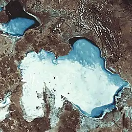 Satellite image of the Uyuni salt flat (center) and Mancha (lower left) | |
| Highest point | |
| Elevation | 5,024 m (16,483 ft) [1] |
| Coordinates | 20°27′36″S 68°19′00″W |
| Geography | |
 Mancha Location in Bolivia | |
| Location | Bolivia, Potosí Department |
| Parent range | Andes |
References
- Bolivian IGM map 1:250,000 Estancia Sinalaco 5932-IV
- Teofilo Laime Ajacopa, Diccionario Bilingüe Iskay simipi yuyayk'ancha, La Paz, 2007 (Quechua-Spanish dictionary)
- "Llica". INE, Bolivia. Archived from the original on October 14, 2014. Retrieved October 10, 2014.
Capital: Potosí | ||
| Provinces |  | |
| Municipalities (and seats) |
| |
This article is issued from Wikipedia. The text is licensed under Creative Commons - Attribution - Sharealike. Additional terms may apply for the media files.