Manila (province)
Manila, also formerly known as Tondo until 1859, was a historical province in the Philippines, encompassing the former pre-Hispanic polities of Tondo, Maynila and Namayan.[1] In 1898, it included the City of Manila and 23 other municipalities. It was incorporated into the Province of Rizal in 1901.
| Manila Maynila | |||||||||||||||
|---|---|---|---|---|---|---|---|---|---|---|---|---|---|---|---|
| Former province of the Philippines | |||||||||||||||
| 1571–1901 | |||||||||||||||
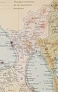
 Location of the historical province of Manila. | |||||||||||||||
| Capital | Manila Mariquina (1898–1899) | ||||||||||||||
| Historical era | Colonial Period | ||||||||||||||
| 1571 | |||||||||||||||
• Became capital of colonial Philippines | 1595 | ||||||||||||||
• Occupied by Great Britain | 1762–1764 | ||||||||||||||
• Sovereignty transferred to United States | 1899 | ||||||||||||||
• Disestablished | 1901 | ||||||||||||||
| |||||||||||||||
| Today part of | |||||||||||||||
Cities and municipalities
The province was composed of the City of Manila and 23 other municipalities. The districts of Binondo, Dilao, Ermita, Malate, Pandacan, Quiapo, Sampaloc, San Miguel, Santa Ana, Santa Cruz, and Tondo are often referred to as "pueblos", "arrabales" ("suburbs") or "neighbourhoods" of Manila. The name Manila originally referred to the "city within the walls" (now Intramuros), but its meaning eventually came to include the suburbs surrounding it, leading to confusion about which places constitute "Manila" in the late 19th century.[1][2] From the 1860s onward, the area was often referred to as Ciudad de Manila y sus arrabales ("The City of Manila and its suburbs") or as Manila y los pueblos de extramuros ("Manila and the communities outside the walls").[2] The present-day City of Manila includes all these areas.
The table below presents information from the cited source.[1]
| City/Municipality | Population (1898) | Notes |
|---|---|---|
| Manila[A 1] | 110,000 | |
| Caloocan | 9,843 | situated 7 miles from Manila. There are highroads to Manila, Novaliches, Mariquina, and Sampaloc. |
| Dilao (Paco)[A 2][A 3] | 4,625 | situated 3 miles from Manila. |
| Ermita[A 2] | 4,726 | situated 1¼ miles from Manila. |
| Las Piñas | 4,000 | situated 8 miles from Manila. |
| Malate[A 2] | 2,319 | situated 1⅔ miles from Manila. |
| Malibay[A 4] | 2,890 | situated 4 miles from Manila. |
| Mariquina[A 5] | 10,313 | situated 7 miles from Manila. It communicates with Caloocan by a highroad. |
| Montalban[A 6] | 3,055 | situated 16 miles from Manila. |
| Muntinlupa | 5,068 | situated 21 miles from Manila. |
| Navotas | 9,154 | situated 6¼ miles from Manila. |
| Novaliches[A 7] | 1,871 | situated 10 miles from Manila. It communicates with Caloocan and Manila by highroads. |
| Pandacan[A 2] | 2,446 | situated 2 miles from Manila. |
| Parañaque | 9,863 | situated at a distance of 6⅛ miles from Manila. |
| Pasig | 22,000 | situated 7 miles from Manila. |
| Pateros | 2,842 | situated 3 miles from Manila. |
| Pineda (Pasay)[A 8] | 9,825 | situated 3⅛ miles from Manila. |
| San Felipe Neri (Mandaluyong)[A 9] | 5,465. | |
| San Juan del Monte[A 10] | 2,011 | |
| San Mateo[A 11] | 6,700 | situated 17 miles from Manila. |
| San Pedro Macati (Makati)[A 12] | 3,921 | situated about 3 miles from Manila. |
| Santa Ana[A 2] | 2,194 | situated about 3 miles from Manila. |
| Tagig (Taguig) | 9,662 | situated 4 miles from Manila. |
| Tambobong (Malabon)[A 13] | 25,000 | situated 3 miles from Manila. |
- Refers to Intramuros
- Now part of the present-day City of Manila
- Refers to Paco, Manila
- United with Pasay on October 12, 1903
- Now Marikina
- Now Rodriguez, Rizal
- Annexed by Caloocan in the early 20th century. Areas that historically belonged to Novaliches are now divided between northern Caloocan and Quezon City
- Now Pasay
- Now Mandaluyong
- Now San Juan
- Now San Mateo, Rizal
- Now Makati
- Now Malabon
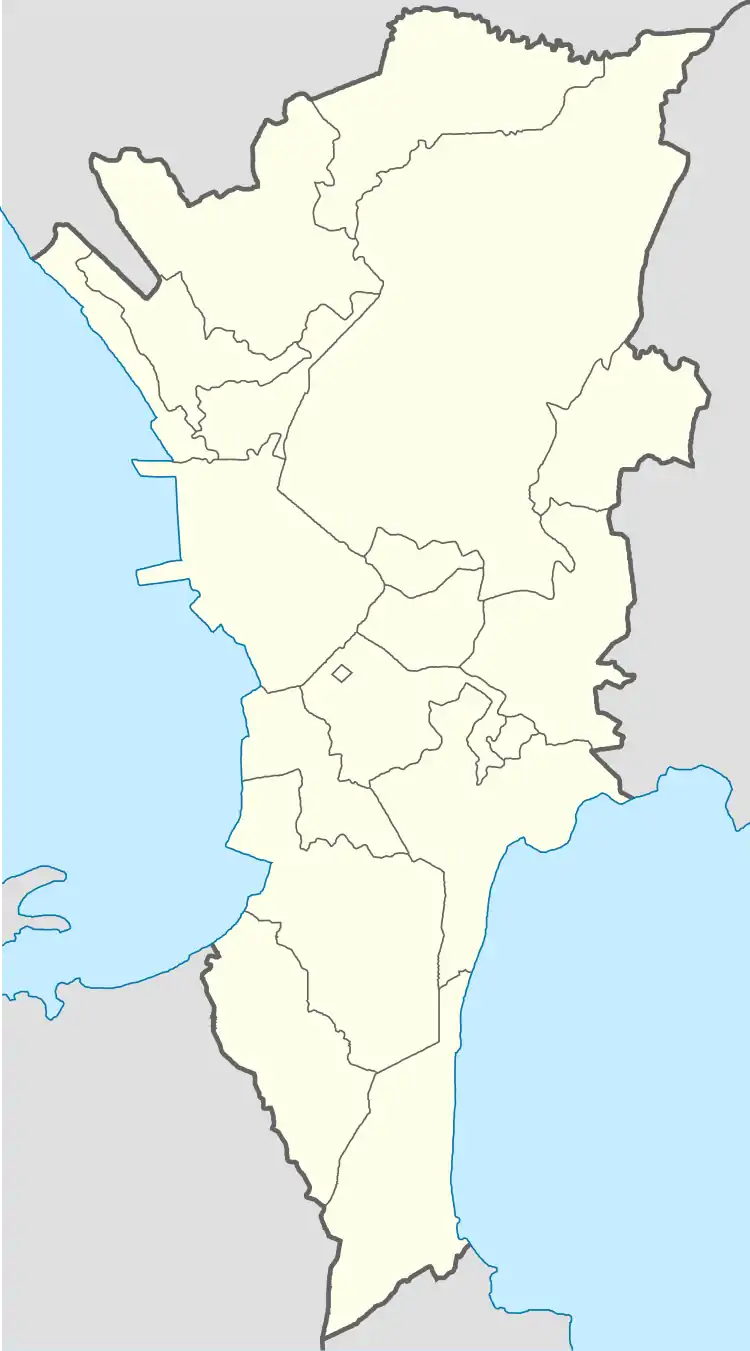
Map
Shown below are the locations of the municipalities of the province of Manila. Except for Montalban and San Mateo, all these areas are included in the present-day cities of Metro Manila.[3]
See also
References
- Military notes on the Philippines: September 1898 By United States. Adjutant-General's Office. Military Information Division
- Old ties and new solidarities: studies on Philippine communities, by Charles J-H. Macdonald, Guillermo Mangubat Pesigan – Shifts in the meaning of "Manila" in the Nineteenth Century – Xavier Huetz de Lemps
- 1901 Map of Luzon, showing the province of Manila