Mehairja
Mehairja (Arabic: محيرجة; also spelled Mehairqa) is a district in Qatar, located in the municipality of Al Rayyan.[3][4]
Mehairja
محيرجة | |
|---|---|
District | |
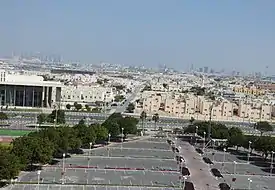 View of Wadi Al Gaiya Street in Mehairja from Aspire Zone parking lot. | |
 Mehairja | |
| Coordinates: 25.2691°N 51.4598°E | |
| Country | |
| Municipality | Al Rayyan |
| Zone | Zone 54 |
| District no. | 81 |
| Area | |
| • Total | 4.0 km2 (1.5 sq mi) |
| Elevation | 21 m (69 ft) |
In the 2015 census it was listed as a district of Zone 54, which has a population of 24,593 and also includes Baaya, Muraikh, Luaib, Fereej Al Soudan, and Fereej Al Amir.[3]
It borders Fereej Al Soudan to the east, Al Waab and Al Aziziya to the south, Muraikh and Luaib to the north and Baaya to the west.[4]
Etymology
The district derives its name from the Arabic word "mahraqa", meaning "burnt". It was so named for its dark-colored soil and for the dark-colored leaves apparent on trees growing in the region which give the impression that its entire landscape had been charred in the past.[4]
References
- "District Area Map". Ministry of Development Planning and Statistics. Retrieved 12 February 2019.
- "Mehairja, Zone 54, Qatar on the Elevation Map". elevationmap.net. Retrieved 3 January 2019.
- "2015 population census" (PDF). Ministry of Development Planning and Statistics. Retrieved 1 January 2019.
- "District map". The Centre for Geographic Information Systems of Qatar. Retrieved 1 January 2019.
Capital: Al Rayyan City | |
| Zone 51 | |
| Zone 52 | |
| Zone 53 | |
| Zone 54 | |
| Zone 55 |
|
| Zone 56 |
|
| Zone 81 | |
| Zone 83 |
|
| Zone 96 |
|
| Zone 97 | |
This article is issued from Wikipedia. The text is licensed under Creative Commons - Attribution - Sharealike. Additional terms may apply for the media files.