Mewar
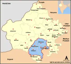
Mewar or Mewad is a region in the south-central part of Rajasthan state of India. It includes the present-day districts of Bhilwara, Chittorgarh, Pratapgarh, Rajsamand, Udaipur, Pirawa Tehsil of Jhalawar District of Rajasthan, Neemuch and Mandsaur of Madhya Pradesh and some parts of Gujarat.
| Historical Region of Rajasthan, India Mewar | |
| Location | Southern Rajasthan |
| Language | Mewari |
| Dynasties | Moris (up to 734 AD) Guhilas (Guhilots) (734–1303), Sisodias (1326–1952) |
| Historical capitals | Nagda, Chittaurgarh, and Udaipur |
For centuries, the region was ruled by Rajputs. The princely state of Udaipur emerged as an administrative unit during the period of British East India Company governance in India and remained until the end of the British Raj era.
The Mewar region lies between the Aravali Range to the northwest, Ajmer to the north, Gujarat and the Vagad region of Rajasthan to the south, the Malwa region of Madhya Pradesh state to the southeast and the Hadoti region of Rajasthan to the east.
Etymology
The word "Mewar" is vernacular form of "Medapata" (IAST: Medapāṭa), the ancient name of the region. The earliest epigraph that mentions the word "Medapata" is a 996–997 CE (1053 VS) inscription discovered at Hathundi (Bijapur). The word "pata" or "pataka" refers to an administrative unit. According to the historian G. C. Raychaudhuri, Medapata was named after the Meda tribe, which has been mentioned in Varāhamihira's Brihat-Samhita.[1] The 1460 Kumbhalgarh inscription associates the Medas with Vardhana-giri (modern Badnor in Mewar region).[2] Historian Sashi Bhusan Chaudhuri associates the ancient Medas with the modern Mer people.[3]
The 1285 CE (1342 VS) Mount Abu (Achaleshwar) inscription of the Guhila king Samarasimha provides the following etymology while describing the military conquests of his ancestor Bappa Rawal (Bappaka): "This country which was, in battle, totally submerged in the dripping fat ('medas' in Sanskrit) of wicked people by Bappaka bears the name of Śrī Medapāṭa." Historian Anil Chandra Banerjee dismisses this as a "poetic fancy".[4]
Geography
The northern and eastern portions of Mewar are made up of an elevated plateau while the western and southern portions were rocky and hilly with dense forests.[5] The watershed divide between drainage of the Bay of Bengal and drainage of the Gulf of Khambhat runs almost through the centre of Mewar.[6] The northern and eastern part of Mewar is a gently sloping plain, drained by the Bedach and Banas River and its tributaries, which empty northwest into the Chambal River, a tributary of the Yamuna River. The southern and western part of the region is hilly, and marks the divide between the Banas and its tributaries and the headwaters of the Sabarmati and Mahi rivers and their tributaries, which drain south into the Gulf of Khambhat through Gujarat state. The Aravalli Range, which forms the northwestern boundary of the region, is composed mostly of sedimentary rocks, like marble and Kota Stone, which has traditionally been an important construction material.
The region is part of the Kathiawar-Gir dry deciduous forests' ecoregion. Protected areas include the Jaisamand Wildlife Sanctuary, the Kumbhalgarh Wildlife Sanctuary, the Bassi Wildlife Sanctuary and the Sita Mata Wildlife Sanctuary.
Mewar has a tropical climate. Rainfall averages 660 mm/year, and is generally higher in the southwest and lower in the northeast of the region. Over 90% of the rain typically falls in the period of June to September every year, during the southwest monsoon.
History
The state of Mewar was founded around 530 AD; later it would also, and ultimately predominantly, called Udaipur after the name of the capital. In 1568, Emperor Akbar conquered Chittorgarh, the capital of Mewar. In 1576, Maharana Pratap, the ruler of Mewar, was defeated at the Battle of Haldighati and Gogunda, Udaipur and Kumbhalgarh were conquered. However through guerrilla warfare, Maharana Pratap recaptured western Mewar.[7] In 1606, Amar Singh defeated the Mughals in the Battle of Dewair. In 1615, after four decades of skirmishing, Mewar and the Mughals entered into a treaty under which Mewar territory under the Mughals' possession was returned in exchange for the crown prince of Mewar attending the Mughal court and Mewar providing a force of 1,000 horsemen to the Mughals.[8][9] When Udaipur State joined the Indian Union in 1949 it had been ruled by the Rajputs of Mori, Guhilot and Sisodia dynasties for over 1,400 years.[10][11] Chittaurgarh was the capital of Sisodia clans of Rajputs of Mewar.
Founding
Bappa Rawal is considered the founder of the Mewar state.[12] While his predecessors had enjoyed control over limited areas in the hilly regions in the west and southwest of Mewar, Bappa was the first ruler to expand the state close to its later boundaries.[12] Bappa, who had his capital at Nagda (19 kilometres north of Udaipur), extended his possessions to the east by ousting Man Singh of the Mori (Maurya) clan from Chittor in 734 AD.[12] He took on the title of 'Rawal.'[12]
Treaty with East India Company
For half a century prior to 1818, the armies of Holkar, Scindia, and Amir Khan had plundered Mewar, pauperising its ruler and people. As early as 1805, Maharana Bhim Singh of Mewar approached the British for assistance but the Treaty of 1803 with Scindia prevented the British from entertaining the request. But by 1817, the British too were anxious to have alliances with Rajput rulers and the Treaty of Friendship, Alliances and Unity was concluded between Mewar and East India Company (on behalf of Britain) on 13 January 1818.[13]
Under the treaty, the British Government agreed to protect the territory of Mewar, in return for which Mewar acknowledged British supremacy and agreed to abstain from political associations with other states and to pay one-fourth of its revenues as tribute for 5 years, and three-eighths in perpetuity.[13] The British authorities granted the ruler of Udaipur a 19 gun salute.[14]
Accession to Republic of India
The last ruler of Udaipur Kingdom signed the accession to Independent India on 7 April 1949.[10]
Jagirdars (nobles)
The nobles of Mewar were numerous and powerful, enjoying rights and privileges that were unusual in other princely states.[15] Mewar nobles exhibited "few of the marks of vassalage observable at other courts" and "take rank above the heir-apparent - a custom unprecedented in India."[15]
Administrative structure
At the time of the 1901 census, the state was divided into 17 administrative sub-divisions - 11 zilas and 6 parganas, the difference between a zila and pargana being that the latter was larger and broken up into further subdivisions.[16] Further, there were 28 principal jagirs and 2 bhumats.[5] Each zila was administered by a hakim, a state official, supported at each tehsil (a zila sub-division) by an assistant hakim.[17]
Land tenure in Mewar State
The principal forms of land tenure in the state were jagir, bhum, sasan, and khalsa.[18] Jagirs were grants of land made in recognition service of a civil or political nature. Jagirdars, the holders of jagir, usually paid a fixed annual tribute called chhatund on an annual basis, and nazarana on the succession of a new Maharana. On the death of a jagirdar, the jagir reverted to the Maharana until the late jagirdar's successor was recognised by the Maharana. Those holding bhum tenures paid a small tribute or nominal quit-rent (bhum barar), and were liable to be called on for local service. Sasan (also known as muafi) holders were not liable for payments to the Maharana but taxes were sometimes recovered from them. Khalsa (crown lands) holders were cultivators who were undisturbed in their possession as long as they continued to pay land revenue.[18] As of 1912, 38% of the land revenue of the State was from khalsa land, the rest from other forms of tenure.[19]
See also
References
- G. C. Raychaudhuri (1940). History of Mewar from the Earliest Times to 1303 A.D. Kanjilal, Calcutta University Press. p. 8. OCLC 917040797.
- Dineschandra Sircar (1963). The Guhilas of Kiṣkindhā. Sanskrit College. p. 38. OCLC 161579.
- Sashi Bhusan Chaudhuri (1955). Ethnic settlements in ancient India. Calcutta: General. p. 26. OCLC 2278769.
- Anil Chandra Banerjee (1958). Medieval studies. A. Mukherjee & Co. p. 19. OCLC 254699661.
- Imperial Gazetteer of India : Provincial Series Rajputana. Calcutta: Superintendent of Government Printing. 1908. pp. 106–168.
- Gupta, R.K.; Bakshi, S.R., eds. (2008). Studies in Indian History: Rajasthan Through the Ages Vol. 5. New Delhi: Sarup & Sons. pp. 64–77. ISBN 978-81-7625-841-8.
- Chandra 2005, pp. 121–122.
- Panagariya, B.L.; Pahariya, N.C. (1947). Political, socio-economic and cultural history of Rajasthan (Earliest times to 1947). Jaipur: Panchsheel Prakashan. Retrieved 2 May 2019.
- Pant 2012, p. 129.
- "Indian Princely States K-Z". www.worldstatesmen.org. Retrieved 25 December 2019.
- "Udaipur State (also called Mewar): History". The Imperial Gazetteer of India. 1909. pp. v. 24, p. 87.
- Erskine, K. D. (1908). A Gazetteer of the Udaipur State with a Chapter on the Bhils and Some Statistical Tables. Ajmer: Scottish Mission Industries Co. Ltd.
- Aitchison, C. U. (1909). A Collection of Treaties, Engagements and Sanads Relating to India and Neighbouring Countries Vol. III. Calcutta: Superintendent Government Printing, India. pp. 10–32.
- Udaipur (Mewar) Princely State (19 gun salute) Archived 27 December 2016 at the Wayback Machine.
- Chiefs and Leading Families in Rajputana (2nd ed.). Calcutta: Office of the Superintendent of Government Printing. 1908.
- Agarwal, B.D. (1979). Rajasthan District Gazetteers: Udaipur. Jaipur: Government of Rajasthan. p. 2.
- Ojha, Gaurishankar Hirachand (1999). उदयपुर राज्य का इतिहास. Jodhpur: Rajasthani Granthagar. pp. 15–16. Archived from the original on 26 February 2017. Retrieved 7 February 2018.
- Erskine, K.D. (1908). Rajputana Gazetteers, Vol II-A (The Mewar Residency). Ajmer: Scottish Mission Industries Co. Ltd. pp. 71–72.
- Administration Report of the Mewar State for the Year 1910-11. Ajmer: Scottish Mission Industries Co., Ltd. 1911. pp. 1.
External links
![]() Media related to Mewar at Wikimedia Commons
Media related to Mewar at Wikimedia Commons
| Wikiquote has quotations related to: Mewar |
Further reading
- Mewar through the ages, by D. L. Paliwal. Sahitya Sansthan, Rajasthan Vidyapeeth, 1970
- The Kingdom of Mewar: great struggles and glory of the world's oldest ruling dynasty, by Irmgard Meininger. D.K. Printworld, 2000. ISBN 81-246-0144-5.
- Costumes of the rulers of Mewar: with patterns and construction techniques, by Pushpa Rani Mathur. Abhinav Publications, 1994. ISBN 81-7017-293-4.
| Outline |
|  | |||||||||||||
|---|---|---|---|---|---|---|---|---|---|---|---|---|---|---|---|
| Governance |
| ||||||||||||||
| Divisions and districts |
| ||||||||||||||
| Major cities | |||||||||||||||
| Related templates |
| ||||||||||||||